File:Map Europe alliances 1914-ru.svg

Size of this PNG preview of this SVG file: 800 × 473 pixels. Other resolutions: 320 × 189 pixels | 640 × 379 pixels | 1,024 × 606 pixels | 1,280 × 758 pixels | 2,560 × 1,515 pixels | 1,002 × 593 pixels.
Original file (SVG file, nominally 1,002 × 593 pixels, file size: 71 KB)
Captions
Captions
Add a one-line explanation of what this file represents
| Description |
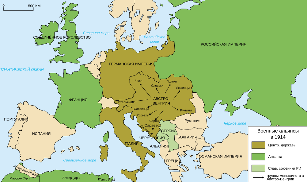
Deutsch: Karte von Militärbündnisse in Europa in 1914, (Russische) English: Map of military alliances of Europe in 1914. (Russian) Français : Carte des alliances militaires en Europe en 1914. (Russe) Русский: Схема военных альянсов в Европе в 1914 г. (Русский) |
| Date | (UTC) |
| Source | Translated in Russian from Map_Europe_alliances_1914-en.svg |
| Author |
|
| This is a retouched picture, which means that it has been digitally altered from its original version. Modifications: russian translation. The original can be viewed here: Map Europe alliances 1914-en.svg:
|
I, the copyright holder of this work, hereby publish it under the following license:
This file is licensed under the Creative Commons Attribution-Share Alike 2.5 Generic, 2.0 Generic and 1.0 Generic license.
- You are free:
- to share – to copy, distribute and transmit the work
- to remix – to adapt the work
- Under the following conditions:
- attribution – You must give appropriate credit, provide a link to the license, and indicate if changes were made. You may do so in any reasonable manner, but not in any way that suggests the licensor endorses you or your use.
- share alike – If you remix, transform, or build upon the material, you must distribute your contributions under the same or compatible license as the original.
Original upload log edit
This image is a derivative work of the following images:
- File:Map_Europe_alliances_1914-en.svg licensed with Cc-by-sa-2.5,2.0,1.0
- 2010-11-17T16:49:33Z Ras67 1002x593 (71984 Bytes) "cropped" and minor things
- 2010-11-10T16:24:07Z EmilJ 998x593 (89908 Bytes) oh bugger
- 2010-11-10T16:22:19Z EmilJ 998x593 (89908 Bytes) fix gratuitous caps
- 2010-11-10T16:19:02Z EmilJ 998x593 (89908 Bytes) fix names
- 2010-05-21T17:36:30Z 孟柏民 998x593 (101359 Bytes) Converted some residual German names into English
- 2010-03-07T10:00:45Z Mnmazur 998x593 (101363 Bytes)
- 2009-01-13T10:39:22Z Bibi Saint-Pol 998x593 (127714 Bytes) fix typo problem
- 2009-01-13T10:33:07Z Bibi Saint-Pol 998x593 (100765 Bytes) new version, more complete
- 2009-01-12T20:04:56Z Fluteflute 998x593 (83132 Bytes) {{Information |Description={{en|Map of military alliances of Europe in 1914.}} {{fr|Carte des alliances militaires en Europe en 1914.}} |Source=*[[:File:Map_Europe_alliances_1914-fr.svg|]] |Date=2009-01-12 20:04 (UTC) |Author
Uploaded with derivativeFX
File history
Click on a date/time to view the file as it appeared at that time.
| Date/Time | Thumbnail | Dimensions | User | Comment | |
|---|---|---|---|---|---|
| current | 14:57, 2 August 2020 | | 1,002 × 593 (71 KB) | Bogomolov.PL (talk | contribs) | удалены водохранилища на Днепре, Дону и Волге, они были созданы лишь после Второй мировой войны |
| 07:03, 12 April 2017 |  | 1,002 × 593 (76 KB) | AshFox (talk | contribs) | Российская империя. Не Россия | |
| 21:20, 28 November 2015 |  | 1,002 × 593 (76 KB) | Turnless (talk | contribs) | Aland Islands | |
| 12:19, 2 January 2015 |  | 1,002 × 593 (76 KB) | Borodun (talk | contribs) | Моонзундский архипелаг принадлежал России | |
| 08:19, 18 November 2010 |  | 1,002 × 593 (69 KB) | Bronikkk (talk | contribs) | {{Information |Description={{ru|Схема военных альянсов в Европе в 1914 г.}} |Source=*File:Map_Europe_alliances_1914-en.svg |Date=2010-11-18 08:18 (UTC) |Author=*File:Map_Europe_alliances_1914-en.svg: * [[User:Histo |
You cannot overwrite this file.
File usage on Commons
The following 37 pages use this file:
- User:Magog the Ogre/Maps of conflicts/2015 November
- User:Magog the Ogre/Maps of conflicts/2017 April
- File:1914 ஐரோப்பியக் கூட்டணிகள்.svg
- File:1914년 유럽의 군사동맹지도.PNG
- File:Alliances militaires en Europe 1914-1918-hy.png
- File:Map Europe alliances 1914-ar.svg
- File:Map Europe alliances 1914-az.svg
- File:Map Europe alliances 1914-bg.svg
- File:Map Europe alliances 1914-bn.svg
- File:Map Europe alliances 1914-ce.svg
- File:Map Europe alliances 1914-cs.svg
- File:Map Europe alliances 1914-de.svg
- File:Map Europe alliances 1914-el.svg
- File:Map Europe alliances 1914-en.svg
- File:Map Europe alliances 1914-eo.svg
- File:Map Europe alliances 1914-es.svg
- File:Map Europe alliances 1914-fr.svg
- File:Map Europe alliances 1914-gl.svg
- File:Map Europe alliances 1914-he.svg
- File:Map Europe alliances 1914-hr.svg
- File:Map Europe alliances 1914-hu.svg
- File:Map Europe alliances 1914-hy.jpg
- File:Map Europe alliances 1914-it.svg
- File:Map Europe alliances 1914-ko.svg
- File:Map Europe alliances 1914-la.svg
- File:Map Europe alliances 1914-lt.svg
- File:Map Europe alliances 1914-mk.svg
- File:Map Europe alliances 1914-nl.svg
- File:Map Europe alliances 1914-no.svg
- File:Map Europe alliances 1914-ro.svg
- File:Map Europe alliances 1914-sr.svg
- File:Map Europe alliances 1914-sv.svg
- File:Map Europe alliances 1914-ta.png
- File:Map Europe alliances 1914-uk.svg
- File:PotenciasEnLiza1914-pt.svg
- File:PotenciasEnLiza1914.svg
- Template:Other versions/Map Europe alliances 1914
File usage on other wikis
The following other wikis use this file:
- Usage on ba.wikipedia.org
- Usage on be.wikipedia.org
- Usage on cv.wikipedia.org
- Usage on kbd.wikipedia.org
- Usage on ru.wikipedia.org
- Италия
- Первая мировая война
- Антанта
- Июльский кризис
- Участник:DJ Rome
- История Франции (1789—1914)
- Участник:Сепетов
- Участник:Михаил Рус
- Участник:Rubbyn
- Шаблон:Userbox/Интерес:Первая мировая война
- Участник:VolnyiLev
- 1914 год в России
- Участник:SHOCK-25
- Участник:La loi et la justice
- Участник:MrReckart
- Участник:Уолдер
- Участник:AQVA121/Обо мне
- Участник:Bemule
- Участник:Полковник Голем
- Участник:Sasha Kuznetcova
- Участник:Wilhelm II. Hohenzollern/Обо мне
- Участник:Danlensky
- Участник:Demer Nkardaz
- Участник:Noraskulk
- Участник:22.Oleg.Zvonov33
- Участник:Егор Сергеевич Кравчук
- Участник:1kovand1
- Участник:Shandroo
- Участник:Friedrich Afton
- Участник:DokiDotto
- Участник:Arseniy1302/Юзербоксы
- Участник:Dmytry 123
- Участник:Ananasik gorilla
- Участник:Zedaru
- Сан-Джулиано, Антонино Патерно-Кастелло ди
- Участник:FedorkaFend
- Участник:Volterius 1
- Участник:Wurm00009
- Участник:Fifuse
- Участник:'Εκπύρωσις
- Участник:Министерство Атаки
- Участник:Galstyan Karen Artyushovich
- Участник:Kutmin
- Usage on vep.wikipedia.org