File:Map Exogenous Dynamics II 1990 - Landslides - Langhe cuneesi - Touring Club Italiano CART-TEM-020 (cropped).jpg

Size of this preview: 430 × 599 pixels. Other resolutions: 172 × 240 pixels | 344 × 480 pixels | 551 × 768 pixels | 735 × 1,024 pixels | 1,433 × 1,996 pixels.
Original file (1,433 × 1,996 pixels, file size: 2.79 MB, MIME type: image/jpeg)
Captions
Captions
Add a one-line explanation of what this file represents
Summary edit
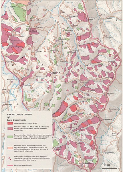
| Title |
Exogenous Dynamics II |
|
| Description |
English: The table focuses on the danger represented by natural disasters. More specifically: B) Landslides - Langhe cuneesi. Scale: 1: 100 000. The table is part of the Tematic Atlas realized by the TCI Cartographic Office with CNR - Italian National Research Council (1989-1992) Italiano: La tavola mette a fuoco il pericolo rappresentato dai disastri naturali: B) Frane - Langhe cuneesi. Scala: 1: 100 000. La tavola fa parte dell'Atlante Tematico realizzato dall'Ufficio Cartografico del TCI con il CNR - Consiglio Nazionale delle Ricerche (1989-1992) |
|
| Date | ||
| Source | Scan from the original work Archivio Storico del Touring Club Italiano | |
| Creator |
TCI Cartographic Office |
|
| Permission (Reusing this file) |
|
|
| Geotemporal data | ||
| Map location | Italy | |
| Map type | Maps of natural disasters | |
| Scale | 1: 100 000 | |
| Georeferencing | If inappropriate please set warp_status = skip to hide. | |
| Bibliographic data | ||
| Part of the series | Thematic Atlas of Italy | |
| Language | Italian | |
| Place of publication | Milan | |
| Publisher |
TCI |
|
| Printed by |
TCI |
|
| Archival data | ||
| Collection | ||
| Accession number |
CART.TEM.020 |
|
| Other versions | ||


.jpg&action=edit§ion=1)
Licensing edit
.jpg&action=edit§ion=2)
File history
Click on a date/time to view the file as it appeared at that time.
| Date/Time | Thumbnail | Dimensions | User | Comment | |
|---|---|---|---|---|---|
| current | 14:57, 10 November 2022 | | 1,433 × 1,996 (2.79 MB) | Marta Arosio (WMIT) (talk | contribs) | File:Map Exogenous Dynamics II 1990 - Touring Club Italiano CART-TEM-020.jpg cropped 71 % horizontally, 41 % vertically using CropTool with lossless mode. |
You cannot overwrite this file.
File usage on Commons
The following 2 pages use this file:
File usage on other wikis
The following other wikis use this file:
- Usage on it.wikipedia.org
.jpg&oldid=858433343)