File:Map France 1180-ru.svg

Size of this PNG preview of this SVG file: 527 × 600 pixels. Other resolutions: 211 × 240 pixels | 422 × 480 pixels | 675 × 768 pixels | 900 × 1,024 pixels | 1,800 × 2,048 pixels | 988 × 1,124 pixels.
Original file (SVG file, nominally 988 × 1,124 pixels, file size: 1.88 MB)
Captions
Captions
Add a one-line explanation of what this file represents
Summary edit
| Description |
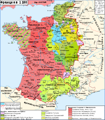
Русский: Карта Франции в 1180
English: Map of France in 1180
Français : Carte de la France en 1180
Deutsch: Karte Frankreichs im Jahr 1180 |
| Date | |
| Source | |
| Author |
Sources:
|
| Other versions |
|


| This is a retouched picture, which means that it has been digitally altered from its original version. Modifications: Russian translation. The original can be viewed here: Map France 1180-fr.svg:
|
Légende edit
Licensing edit
I, the copyright holder of this work, hereby publish it under the following licenses:

|
Permission is granted to copy, distribute and/or modify this document under the terms of the GNU Free Documentation License, Version 1.2 or any later version published by the Free Software Foundation; with no Invariant Sections, no Front-Cover Texts, and no Back-Cover Texts. A copy of the license is included in the section entitled GNU Free Documentation License. |
This file is licensed under the Creative Commons Attribution-Share Alike 3.0 Unported, 2.5 Generic, 2.0 Generic and 1.0 Generic license.
- You are free:
- to share – to copy, distribute and transmit the work
- to remix – to adapt the work
- Under the following conditions:
- attribution – You must give appropriate credit, provide a link to the license, and indicate if changes were made. You may do so in any reasonable manner, but not in any way that suggests the licensor endorses you or your use.
- share alike – If you remix, transform, or build upon the material, you must distribute your contributions under the same or compatible license as the original.
You may select the license of your choice.
File history
Click on a date/time to view the file as it appeared at that time.
| Date/Time | Thumbnail | Dimensions | User | Comment | |
|---|---|---|---|---|---|
| current | 12:20, 15 November 2014 | | 988 × 1,124 (1.88 MB) | Vladimir Solovjev (talk | contribs) | Correct |
| 12:00, 15 November 2014 |  | 988 × 1,124 (1.87 MB) | Vladimir Solovjev (talk | contribs) | == {{int:filedesc}} == {{Information |Description={{ru|Карта Франции в 1180}} {{en|1=Map of France in 1180}} {{fr|1=Carte de la France en 1180}} |Source=Map File:Map France 1180-fr.svg Original Source: {{en|Own work, from [[:Image:Fra... |
You cannot overwrite this file.
File usage on Commons
The following page uses this file:
File usage on other wikis
The following other wikis use this file:
- Usage on ru.wikipedia.org