File:Map France 1477-de.svg

Original file (SVG file, nominally 900 × 970 pixels, file size: 2.74 MB)
Captions
Captions
Summary edit
| Description |
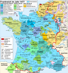
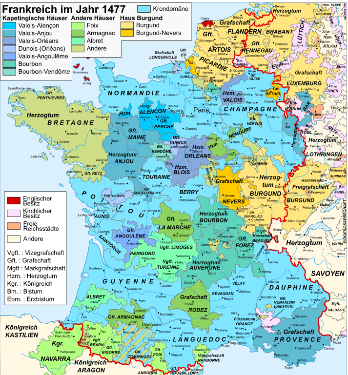
Deutsch: Karte Frankreichs im Jahr 1477.
Français : Carte de la France en 1477.
English: Map of France in 1477. |
||||||||
| Date | (UTC) | ||||||||
| Source | |||||||||
| Author |
|
||||||||
| Permission (Reusing this file) |
I, the copyright holder of this work, hereby publish it under the following licenses: This file is licensed under the Creative Commons Attribution-Share Alike 2.5 Generic license.
You may select the license of your choice. |
||||||||
| Other versions |
[]
|


| This is a retouched picture, which means that it has been digitally altered from its original version. Modifications: traduction allemand / deutsche Übersetzung / German translation. The original can be viewed here: Map France 1477-fr.svg:
|
Original upload log edit
This image is a derivative work of the following images:
- File:Map_France_1477-fr.svg licensed with Cc-by-sa-2.5, Cc-by-sa-3.0-migrated, GFDL
- 2007-04-20T11:10:17Z Bibi Saint-Pol 900x970 (1280806 Bytes) {{Created with Inkscape}} == Description == {{Information |Description= {{en|Map of the France in 1477.}} {{fr|Carte de la France en 1477.}} |Source= {{fr| *[[:Image:France XVe siècle.jpg|France in the late 15th century]], t
Uploaded with derivativeFX
Legende edit
|
Krondomäne (Domaine royal):
Rote Linie: Grenze des Königreichs Frankreich
Kapetingische Häuser (Valois, Bourbon): Valois-Alençon:
— Herzogtum Alençon (1220) — Grafschaft Perche (1227) Valois-Anjou:
— Herzogtum Anjou (1204) — Grafschaft Provence (1498) — Herzogtum Bar (1766) Karl V. von Anjou: — Grafschaft Maine (1204) — Grafschaft Guise (1688) — Grafschaft Gien (1199) — Vizegrafschaft Châtellerault (1482) Valois-Orléans (Ludwig von Orléans, der spätere König Ludwig XII.):
— Herzogtum Orléans (987) — Herzogtum Valois (1214) Orléans-Dunois (Franz I. von Orléans, Sohn von Jean de Dunois:
— Grafschaft Dunois (1707) — Grafschaft Longueville (XIII. Jahrhundert) — Herrschaft Parthenay (1419) Valois-Angoulême (Karl von Orléans (1459-1496)):
— Grafschaft Angoulême (1308) Bourbon (Johann II. von Bourbon):
— Herzogtum Bourbon (1531) — Herzogtum Auvergne (seit 1200) — Grafschaft Forez (1531) — Grafschaft Clermont (1218) Peter II. von Bourbon: — Herrschaft Beaujeu (1531) |
Andere Häuser:
Haus Burgund: Haus Burgund (Karl der Kühne):
— Herzogtum Burgund (1016) — Grafschaft Charolais (1751) — Sundgau (1648) — Picardie (XII.-XIII. Jahrhundert) — Grafschaft Artois (1185) — Grafschaft Hennegau (1659, 1678) — Grafschaft Flandern (1678) — Herzogtum Brabant (-) — Herzogtum Geldern (-) Haus Bourgogne-Nevers (Johann von Burgund (1415-1491)):
— Grafschaft Nevers (?) — Grafschaft Rethel (?) — Grafschaft Eu (?)
Haus Foix (Franz Phébus):
— Grafschaft Foix (1589) — Grafschaft Bigorre (1322) — Vizegrafschaft Béarn (1589) — Königreich Navarra (1589) — Fürstentum Andorre (-) Johann von Foix-Étampes, Bruder von Franz Phébus: — Vizegrafschaft Narbonne (1507) Haus Armagnac (Karl I. von Armagnac):
— Grafschaft Armagnac (1589) — Grafschaft Rodez (1589) Jacques d'Armagnac-Nemours, Graf von Pardiac: — Grafschaft Marche (1531) — Herzogtum Nemours (1274) Haus Albret (Alain d'Albret):
— Herrschaft Albret (1589) — Vizegrafschaft Limoges (1589) — Grafschaft Périgord (1589)
Verschiedene Häuser:
Haus Bretagne (Franz II.): — Herzogtum Bretagne (1532) — Grafschaft Vertus (1284) Haus Montpensier (Ludwig I. von Montpensier, Grafschaft Montpensier und Dauphin d'Auvergne): — Grafschaft Sancerre (1434) Haus Chalon (Johann IV. von Chalon-Arlay): — Fürstentum Orange (1673) Haus Husson-Tonnerre (Karl von Husson): — Grafschaft Tonnerre (?) Haus Lothringen (Rainer II. von Lothringen): — Grafschaft Aumale (1194) ? — Vizegrafschaft Soule (1510 [1]) |
|
Lehen des Königreichs:
— Grafschaft Roussillon (1659) — Herzogtum Savoyen (Bresse, Bugey, Gex: 1601, Savoyen: 1860) — Herzogtum Lothringen (1766) — Grafschaft Montbéliard (Mömpelgard) (1793) — Grafschaft Blâmont (1766) — Fürstentum Salm (1793) Kirchlicher Besitz:
— Grafschaft Venaissin, Avignon (päpstlicher Besitz) (1791) — Bistümer Metz, Verdun und Toul (1552-1648) — Cambrai (1678) Freie Reichsstädte
Englische Besitzungen
(1589): Jahr der Eingliederung in die Krondomäne bzw. in den französischen Staat |
File history
Click on a date/time to view the file as it appeared at that time.
| Date/Time | Thumbnail | Dimensions | User | Comment | |
|---|---|---|---|---|---|
| current | 08:30, 23 September 2010 | | 900 × 970 (2.74 MB) | Furfur (talk | contribs) | Schriften in Konturen umgewandelt |
| 08:19, 23 September 2010 |  | 900 × 970 (600 KB) | Furfur (talk | contribs) | kleine Korrektur | |
| 19:51, 22 September 2010 |  | 900 × 970 (2.66 MB) | Furfur (talk | contribs) | Fehlerkorrektur | |
| 19:45, 22 September 2010 |  | 900 × 970 (2.66 MB) | Furfur (talk | contribs) | kosmetische Änderungen | |
| 19:07, 22 September 2010 |  | 900 × 970 (2.66 MB) | Furfur (talk | contribs) | {{Information |Description={{de|Karte Frankreichs im Jahr 1477.}} {{fr|Carte de la France en 1477.}} {{en|Map of France in 1477.}} |Source=*File:Map_France_1477-fr.svg |Date=2010-09-22 19:03 (UTC) |Author=*File:Map_France_1477-fr.svg: [[User: |
You cannot overwrite this file.
File usage on Commons
The following 9 pages use this file:
File usage on other wikis
The following other wikis use this file:
- Usage on de.wikipedia.org
- Usage on el.wikipedia.org
- Usage on en.wikipedia.org
- Usage on hy.wikipedia.org
- Usage on la.wikipedia.org
- Usage on lt.wikipedia.org