File:Map Gaul divisions 511-de.svg

Size of this PNG preview of this SVG file: 577 × 599 pixels. Other resolutions: 231 × 240 pixels | 462 × 480 pixels | 740 × 768 pixels | 986 × 1,024 pixels | 1,972 × 2,048 pixels | 755 × 784 pixels.
Original file (SVG file, nominally 755 × 784 pixels, file size: 125 KB)
File information
Structured data
Captions
Captions
Add a one-line explanation of what this file represents
Summary
edit| DescriptionMap Gaul divisions 511-de.svg |
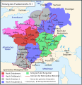
Deutsch: Reichsteilung des Frankenreichs nach dem Tod Chlodwigs im Jahr 511.
Français : La division de la Gaule en 511. |
| Date | (UTC) |
| Source | |
| Author |
|
| Other versions |
[edit]
See alsoedit |
| This is a retouched picture, which means that it has been digitally altered from its original version. Modifications: Deutsche Übersetzung/Traduction allemand. The original can be viewed here: Map Gaul divisions 511-fr.svg:
|
I, the copyright holder of this work, hereby publish it under the following license:
| Public domainPublic domainfalsefalse |
| I, the copyright holder of this work, release this work into the public domain. This applies worldwide. In some countries this may not be legally possible; if so: I grant anyone the right to use this work for any purpose, without any conditions, unless such conditions are required by law. |
Original upload log
editThis image is a derivative work of the following images:
- File:La_division_de_la_Gaule_en_511.svg licensed with PD-self
- 2010-04-03T10:06:10Z Romain0 755x784 (249883 Bytes) Titre.
- 2010-03-14T11:07:34Z Romain0 755x784 (222787 Bytes) Idem.
- 2010-03-14T11:06:21Z Romain0 755x784 (217044 Bytes) Légende.
- 2010-02-16T18:03:38Z Romain0 755x784 (212511 Bytes) Légende.
- 2010-02-16T17:59:12Z Romain0 755x784 (212516 Bytes) Caractères.
- 2010-02-16T17:54:48Z Romain0 755x784 (218444 Bytes)
- 2010-01-03T21:54:36Z Romain0 755x784 (220084 Bytes) Recadrage.
- 2010-01-03T21:50:24Z Romain0 1800x1928 (220050 Bytes) {{Information |Description={{fr|1=La division de la Gaule en 511.}} |Source=Travail personnel sur un fond de carte de [[User:Historicair|historicair]] : [[:Image:Blank map of Gaul 1st century BC.svg]]. D'après [[Paul Vidal d
Uploaded with derivativeFX
File history
Click on a date/time to view the file as it appeared at that time.
| Date/Time | Thumbnail | Dimensions | User | Comment | |
|---|---|---|---|---|---|
| current | 16:53, 3 September 2018 |  | 755 × 784 (125 KB) | Furfur (talk | contribs) | Kosmetik |
| 16:28, 3 September 2018 |  | 755 × 784 (122 KB) | Furfur (talk | contribs) | Korrektur | |
| 16:57, 22 November 2013 |  | 755 × 784 (661 KB) | Furfur (talk | contribs) | neue Farben | |
| 09:53, 16 December 2010 |  | 755 × 784 (661 KB) | Furfur (talk | contribs) | Grenzen der Provinzen -> Grenzen der Metropolitan-Bistümer | |
| 11:55, 29 November 2010 |  | 755 × 784 (650 KB) | Furfur (talk | contribs) | "Städt. Bischofssitz" in "Metropolitan-Bischofssitz" umgenannt. | |
| 12:29, 8 September 2010 |  | 755 × 784 (652 KB) | Furfur (talk | contribs) | Schriftgrößen verändert | |
| 09:26, 8 September 2010 |  | 755 × 784 (657 KB) | Furfur (talk | contribs) | Aquitanien anders eingefärbt | |
| 09:22, 8 September 2010 |  | 755 × 784 (656 KB) | Furfur (talk | contribs) | Änderungen, entsprechend Diskussion ([http://de.wikipedia.org/wiki/Diskussion:Chlodwig_I.#Karte_Gallien_im_Jahr_481] | |
| 13:41, 6 September 2010 |  | 755 × 784 (661 KB) | Furfur (talk | contribs) | {{Information |Description={{de|1=Reichsteilung des Frankenreichs nach dem Tod Chlodwigs im Jahr 511.}} {{fr|1=La division de la Gaule en 511.}} |Source=*File:La_division_de_la_Gaule_en_511.svg |Date=2010-09-06 13:36 (UTC) |Author=*[[:File:La_divisi |
You cannot overwrite this file.
File usage on Commons
The following 7 pages use this file:
- User:J budissin/Uploads/BiH/2018 September 1-10
- File:La division de la Gaule en 511-es.svg
- File:La division de la Gaule en 511 de.svg (file redirect)
- File:Map Gaul divisions 511-de.svg
- File:Map Gaul divisions 511-fr.svg
- File:Map Gaul divisions 511-pt.svg
- Template:Other versions/Map Gaul divisions 511
File usage on other wikis
The following other wikis use this file:
- Usage on bg.wikipedia.org
- Usage on de.wikipedia.org
- Usage on de.wikiversity.org
- Usage on frr.wikipedia.org
- Usage on sv.wikipedia.org
- Usage on www.wikidata.org
Metadata
This file contains additional information such as Exif metadata which may have been added by the digital camera, scanner, or software program used to create or digitize it. If the file has been modified from its original state, some details such as the timestamp may not fully reflect those of the original file. The timestamp is only as accurate as the clock in the camera, and it may be completely wrong.
| Width | 755.074px |
|---|---|
| Height | 783.848px |


