File:Map Health I 1992 - Touring Club Italiano CART-TEM-037.jpg

Size of this preview: 800 × 522 pixels. Other resolutions: 320 × 209 pixels | 640 × 418 pixels | 1,024 × 669 pixels | 1,280 × 836 pixels | 2,560 × 1,672 pixels | 5,000 × 3,265 pixels.
Original file (5,000 × 3,265 pixels, file size: 9.15 MB, MIME type: image/jpeg)
Captions
Captions
Add a one-line explanation of what this file represents
Summary edit
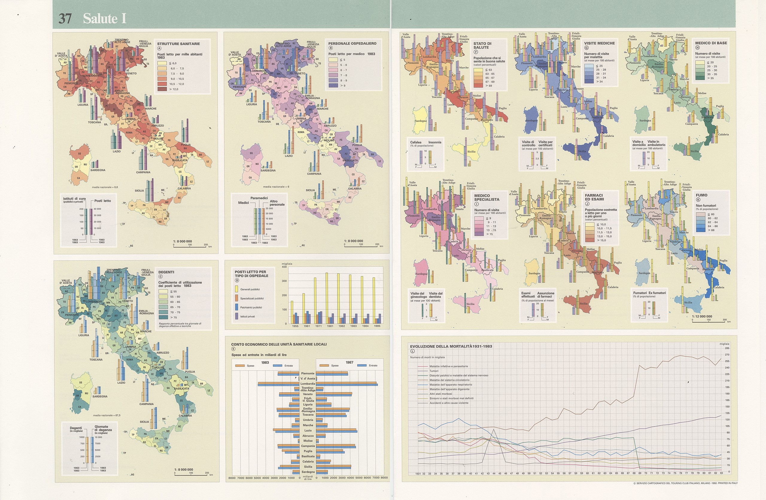
| Title |
Health I |
|
| Description |
English: The table focuses on two index of healts: the presence and the regular activity of public health structures and the geographical distribution of mortality due to the most relevant disease. More specifically: A)Public health structures. Scale: 1: 8 000 000; B)Hospital personnel. Scale: 1: 8 000 000; C)Patients. Scale: 1: 8 000 000; D)Number of beds per type of hospital; E)Balance of local health services; F)State of health. Scale: 1: 12 000 000; G)Medical visits. Scale: 1: 12 000 000; H)General practitioner. Scale: 1: 12 000 000; I)Medical specialist; J)Drugs and tests; K)Smoke; L)Evolution of cause of death 1931-1983. The table is part of the Tematic Atlas realized by the TCI Cartographic Office with CNR - Italian National Research Council (1989-1992) Italiano: La tavola si focalizza su due indici di valutazione della salute: la presenza e regolare funzionamento di strutture di sanità pubblica e la distribuzione geografica della mortalità per le più diffuse cause. In dettaglio: A)Strutture sanitarie. Scala: 1: 8 000 000; B)Personale ospedaliero. Scala: 1: 8 000 000; C) Degenti. Scala: 1: 8 000 000; D)Posti letto per tipo di ospedale; E)Conto economico delle Unità Sanitarie Locali; F)Stato di salute. Scala: 1: 12 000 000; G) Visite mediche. Scala: 1: 12 000 000; H)Medico di base. Scala: 1: 12 000 000; I) Medico specialista; J)Farmaci ed esami; K)Fumo; L)Evoluzione della mortalità 1931-1983. La tavola fa parte dell'Atlante Tematico realizzato dall'Ufficio Cartografico del TCI con il CNR - Consiglio Nazionale delle Ricerche (1989-1992) |
|
| Date | ||
| Source | Scan from the original work Archivio Storico del Touring Club Italiano | |
| Creator |
TCI Cartographic Office |
|
| Permission (Reusing this file) |
|
|
| Geotemporal data | ||
| Map location | Italy | |
| Map type | Demographic maps - Population maps - Health maps | |
| Scale | 1: 8 000 000; 1: 12 000 000 | |
| Georeferencing | If inappropriate please set warp_status = skip to hide. | |
| Bibliographic data | ||
| Part of the series | Thematic Atlas of Italy | |
| Language | Italian | |
| Place of publication | Milan | |
| Publisher |
TCI |
|
| Printed by |
TCI |
|
| Archival data | ||
| Collection | ||
| Accession number |
CART.TEM.037 |
|

Licensing edit
File history
Click on a date/time to view the file as it appeared at that time.
| Date/Time | Thumbnail | Dimensions | User | Comment | |
|---|---|---|---|---|---|
| current | 15:13, 2 November 2022 | | 5,000 × 3,265 (9.15 MB) | Ilaria Parma (TCI) (talk | contribs) | pattypan 22.03 |
You cannot overwrite this file.
File usage on Commons
The following page uses this file: