File:Map Thirteen Colonies 1775-es.svg

Size of this PNG preview of this SVG file: 800 × 550 pixels. Other resolutions: 320 × 220 pixels | 640 × 440 pixels | 1,024 × 704 pixels | 1,280 × 879 pixels | 2,560 × 1,759 pixels | 914 × 628 pixels.
Original file (SVG file, nominally 914 × 628 pixels, file size: 233 KB)
Captions
Captions
Add a one-line explanation of what this file represents
Summary edit
| Description |
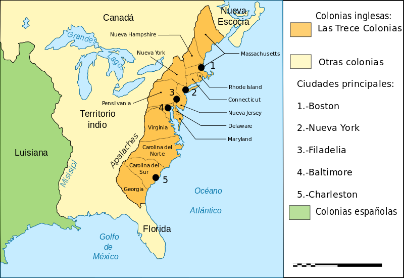
English: Chart of the Thirteen Colonies of North America before U.S. Independence (around 1775).
Español: Las Trece Colonias de América del Norte hacia 1775.
Français : Carte des Treize Colonies d'Amérique du Nord avant l'indépendance (vers 1775). |
| Date | (UTC) |
| Source |
This file was derived from: Map Thirteen Colonies 1775-fr.svg: |
| Author |
|
| This is a retouched picture, which means that it has been digitally altered from its original version. Modifications: translated into Spanish. The original can be viewed here: Map Thirteen Colonies 1775-fr.svg:
|
Licensing edit
This file is licensed under the Creative Commons Attribution-Share Alike 3.0 Unported license.
- You are free:
- to share – to copy, distribute and transmit the work
- to remix – to adapt the work
- Under the following conditions:
- attribution – You must give appropriate credit, provide a link to the license, and indicate if changes were made. You may do so in any reasonable manner, but not in any way that suggests the licensor endorses you or your use.
- share alike – If you remix, transform, or build upon the material, you must distribute your contributions under the same or compatible license as the original.
Original upload log edit
This image is a derivative work of the following images:
- File:Map_Thirteen_Colonies_1775-fr.svg licensed with PD-self
- 2011-07-29T14:47:57Z Litlok 914x628 (281645 Bytes) Il n'y avait pas d'erreur: la Louisiane, suite à la Guerre de Sept Ans, étant espagnole depuis 1762.
- 2009-01-29T13:08:36Z Bibi Saint-Pol 914x628 (286798 Bytes) correction erreur
- 2007-10-02T11:52:29Z Bibi Saint-Pol 914x628 (286790 Bytes) {{Created with Inkscape}} {{Information |Description= {{fr|Carte des Treize Colonies d'Amérique du Nord avant l'indépendance (vers 1775).}} |Source=Own work. Image renamed from [[:Image:Carte des 13 colonies américaines 4.
Uploaded with derivativeFX
File history
Click on a date/time to view the file as it appeared at that time.
| Date/Time | Thumbnail | Dimensions | User | Comment | |
|---|---|---|---|---|---|
| current | 09:00, 23 February 2016 | | 914 × 628 (233 KB) | Rowanwindwhistler (talk | contribs) | Colours from http://colorbrewer2.org/ |
| 16:00, 18 October 2012 |  | 914 × 628 (280 KB) | Rowanwindwhistler (talk | contribs) | == {{int:filedesc}} == {{Information |Description={{en|Chart of the Thirteen Colonies of North America before U.S. Independence (around 1775).}} {{es|1=Las Trece Colonias de América del Norte hacia 1775.}} {{fr|Carte des Treize Colonies d'Amérique du... |
You cannot overwrite this file.
File usage on Commons
The following page uses this file:
File usage on other wikis
The following other wikis use this file:
- Usage on ar.wikipedia.org
- Usage on es.wikipedia.org
- Usage on pt.wikipedia.org