File:Map at nationalpark nockberge location.png

Size of this preview: 622 × 599 pixels. Other resolutions: 249 × 240 pixels | 498 × 480 pixels | 740 × 713 pixels.
Original file (740 × 713 pixels, file size: 100 KB, MIME type: image/png)
Captions
Captions
Add a one-line explanation of what this file represents
Summary edit
| Description |
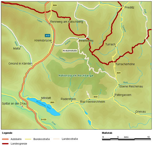
English: Location of national park Nockberge in district Spittal an der Drau in Carinthia / Austria / EU.
Deutsch: Lage des Nationalpark Nockberge in Kärnten / Österreich / Europa. Ortsbezeichnungen / Straßen auf der Karte: Malta, Kremsbrücke, A10, Spittal an der Drau, Millstatt, B98, B100, Drau, Radenthein, Bad Kleinkirchheim, B95, Nationalpark Nockberge, Rennweg am Katschberg, Lieser, Innerkrems, Krems, Turrach, Predlitz, Turracherhöhe, Gurk, Ebene Reichenau, Patergassen, Gnesau, B95. |
| Date | |
| Source | |
| Author | Michael Glanznig (Mglanznig) |
| Permission (Reusing this file) |
Creative Commons Attribution ShareAlike 2.0 Austria |
| Other versions |
Related Images: |

| Camera location | | View this and other nearby images on: OpenStreetMap |
|---|
Licensing edit
I, the copyright holder of this work, hereby publish it under the following license:
This file is licensed under the Creative Commons Attribution-Share Alike 2.0 Austria license.
- You are free:
- to share – to copy, distribute and transmit the work
- to remix – to adapt the work
- Under the following conditions:
- attribution – You must give appropriate credit, provide a link to the license, and indicate if changes were made. You may do so in any reasonable manner, but not in any way that suggests the licensor endorses you or your use.
- share alike – If you remix, transform, or build upon the material, you must distribute your contributions under the same or compatible license as the original.

File history
Click on a date/time to view the file as it appeared at that time.
| Date/Time | Thumbnail | Dimensions | User | Comment | |
|---|---|---|---|---|---|
| current | 17:03, 26 March 2006 | | 740 × 713 (100 KB) | Mglanznig (talk | contribs) | Name of Millstätter See |
| 19:27, 18 February 2006 |  | 740 × 710 (99 KB) | Mglanznig (talk | contribs) | {{Information| |Description = de: Lage des Nationalpark Nockberge, Kärnten, en: location of national park Nockberge, Austria |Source = selbst zusammengestellt, Geodaten von http://www.demis.nl, Map24 http://at.map24.com und KAGIS http://www.kagis.ktn.gv |
You cannot overwrite this file.
File usage on Commons
The following 4 pages use this file:
File usage on other wikis
The following other wikis use this file:
- Usage on cs.wikipedia.org
- Usage on da.wikipedia.org
- Usage on de.wikipedia.org
- Usage on en.wikipedia.org
- Usage on es.wikipedia.org
- Usage on et.wikipedia.org
- Usage on hu.wikipedia.org
- Usage on hy.wikipedia.org
- Usage on ro.wikipedia.org
- Usage on sk.wikipedia.org
- Usage on sl.wikipedia.org