File:Map hamburg altona 1910.jpg
Size of this preview: 789 × 600 pixels. Other resolutions: 316 × 240 pixels | 632 × 480 pixels | 1,011 × 768 pixels | 1,280 × 973 pixels | 2,605 × 1,980 pixels.
Original file (2,605 × 1,980 pixels, file size: 1.62 MB, MIME type: image/jpeg)
Captions
Captions
Add a one-line explanation of what this file represents
Summary edit
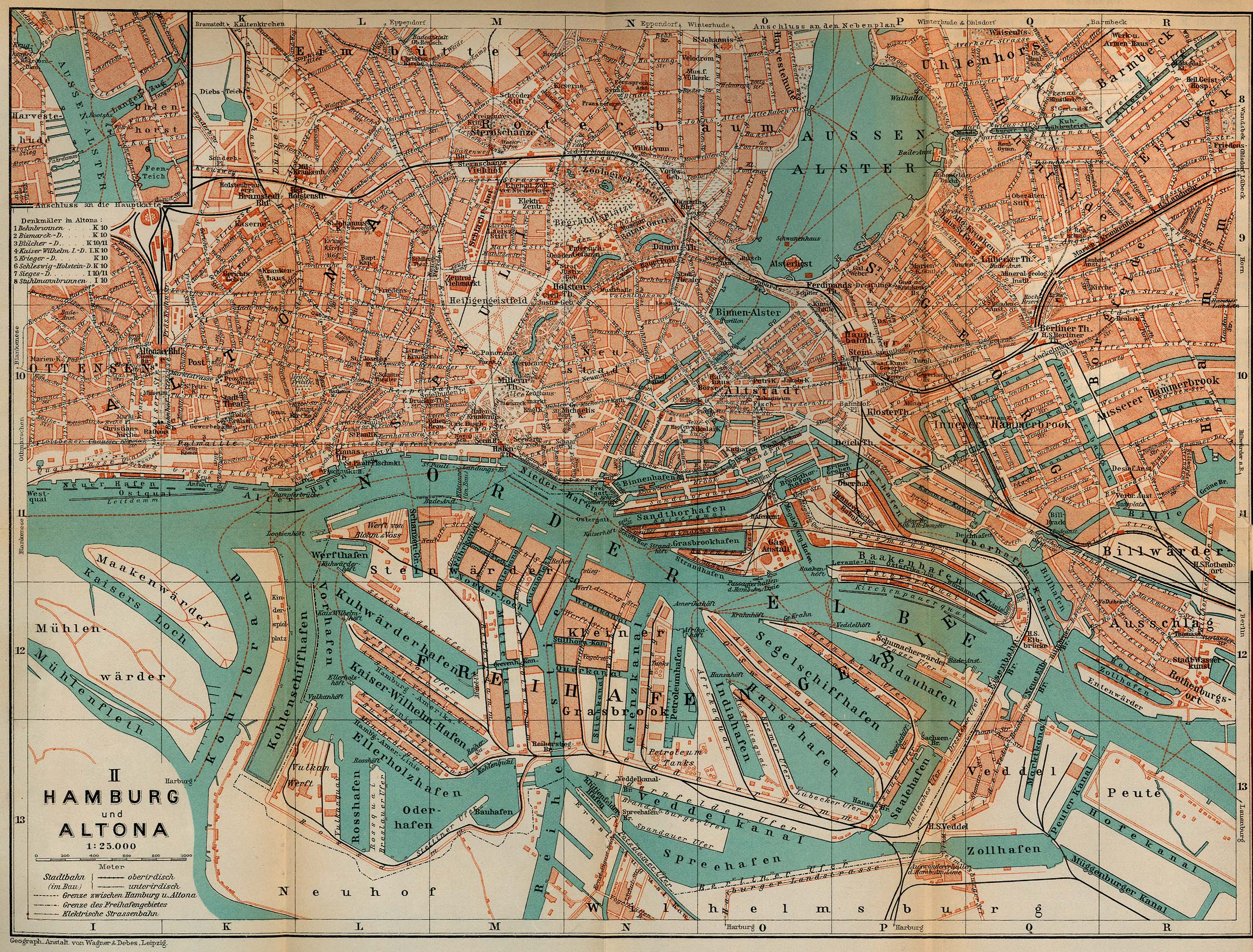
| Description | Map of Hamburg and Altona, Germany, 1910 |
| Date | |
| Source | http://www.lib.utexas.edu/maps/historical/baedeker_n_germany_1910/hamburg_altona_1910.jpg, "Northern Germany as far as the Bavarian and Austrian Frontiers; Handbook for Travellers" by Karl Baedeker. Fifteenth Revised Edition. Leipzig, Karl Baedeker; New York, Charles Scribner's Sons 1910. "Courtesy of the University of Texas Libraries, The University of Texas at Austin." http://www.lib.utexas.edu/maps/map_sites/hist_sites.html |
| Author | |
| Other versions |
Derivative works of this file: |
Licensing edit
This media file is in the public domain in the United States. This applies to U.S. works where the copyright has expired, often because its first publication occurred prior to January 1, 1929, and if not then due to lack of notice or renewal. See this page for further explanation.
|
 | |
 |
This image might not be in the public domain outside of the United States; this especially applies in the countries and areas that do not apply the rule of the shorter term for US works, such as Canada, Mainland China (not Hong Kong or Macao), Germany, Mexico, and Switzerland. The creator and year of publication are essential information and must be provided. See Wikipedia:Public domain and Wikipedia:Copyrights for more details.
|
File history
Click on a date/time to view the file as it appeared at that time.
| Date/Time | Thumbnail | Dimensions | User | Comment | |
|---|---|---|---|---|---|
| current | 08:24, 16 May 2009 | | 2,605 × 1,980 (1.62 MB) | Emma7stern (talk | contribs) | Reverted to version as of 00:07, 23 April 2006 |
| 08:21, 16 May 2009 |  | 911 × 1,040 (1.1 MB) | Emma7stern (talk | contribs) | ausschnitt | |
| 00:07, 23 April 2006 |  | 2,605 × 1,980 (1.62 MB) | 700 MB (talk | contribs) | {{Information| |Description=Map of Hamburg and Altona, Germany, 1910 |Source=http://www.lib.utexas.edu/maps/historical/baedeker_n_germany_1910/hamburg_altona_1910.jpg |Date=1910 |Author="Northern Germany as far as the Bavarian and Austrian Frontiers; Hand |
You cannot overwrite this file.
File usage on Commons
The following 12 pages use this file:
- Hamburg
- File:Altonaer sheruw.jpg
- File:Hamburger Hafen 1910.jpg
- File:Janssen & schmilinsky.jpg
- File:Janssen & schmilinsky2.jpg
- File:Karte-holstenstraße-1910.jpg
- File:Karte Hamburger Hafen 1910.jpg
- File:Map-Altona Große Bergstraße.jpg
- File:Map port of hamburg 1910.jpg
- File:Reiherstiegwerft-karte1790-1910.jpg
- File:Schulterblatt schanzenviertel 1910.jpg
- File:Stülckenwerft.jpg
File usage on other wikis
The following other wikis use this file:
- Usage on ceb.wikipedia.org
- Usage on de.wikipedia.org
- Usage on en.wikipedia.org
- Usage on fr.wikipedia.org
- Usage on sv.wikipedia.org
- Usage on www.wikidata.org