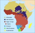
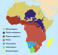
File:Map of African language families.svg

Size of this PNG preview of this SVG file: 635 × 600 pixels. Other resolutions: 254 × 240 pixels | 508 × 480 pixels | 813 × 768 pixels | 1,084 × 1,024 pixels | 2,169 × 2,048 pixels | 1,525 × 1,440 pixels.
Original file (SVG file, nominally 1,525 × 1,440 pixels, file size: 1.05 MB)
File information
Structured data
Captions
Captions
Map of the major language families of Africa
Mapa de les famílies primàries de llengües africanes
Karta över de största språkfamiljerna i Afrika
Summary edit
| DescriptionMap of African language families.svg |
English: Map of the major African language families. Click on any language family in the image to view its respective Wikipedia article.
Bahasa Indonesia: Peta yang menampilkan rumpun bahasa utama di Afrika. Klik nama untuk setiap rumpun bahasa di gambar tersebut untuk melihat artikel yang terkait di Wikipedia.
Legend: |
| Date | |
| Source |
|
| Author | User:SUM1 |
| Other versions |
[edit]
|
This W3C-unspecified vector image was created with Inkscape .
Licensing edit
I, the copyright holder of this work, hereby publish it under the following license:
This file is licensed under the Creative Commons Attribution-Share Alike 4.0 International license.
- You are free:
- to share – to copy, distribute and transmit the work
- to remix – to adapt the work
- Under the following conditions:
- attribution – You must give appropriate credit, provide a link to the license, and indicate if changes were made. You may do so in any reasonable manner, but not in any way that suggests the licensor endorses you or your use.
- share alike – If you remix, transform, or build upon the material, you must distribute your contributions under the same or compatible license as the original.
File history
Click on a date/time to view the file as it appeared at that time.
| Date/Time | Thumbnail | Dimensions | User | Comment | |
|---|---|---|---|---|---|
| current | 20:52, 2 October 2023 |  | 1,525 × 1,440 (1.05 MB) | Xavier Dengra (talk | contribs) | File uploaded using svgtranslate tool (https://svgtranslate.toolforge.org/). Added translation for ca. |
| 02:11, 20 June 2023 |  | 1,525 × 1,440 (1.04 MB) | Illchy (talk | contribs) | File uploaded using svgtranslate tool (https://svgtranslate.toolforge.org/). Added translation for id. | |
| 23:57, 15 July 2017 |  | 1,525 × 1,440 (1.1 MB) | SUM1 (talk | contribs) | Fixed drop shadows glitch | |
| 23:43, 15 July 2017 |  | 1,525 × 1,440 (1.13 MB) | SUM1 (talk | contribs) | Fixed Niger–Congo boundary | |
| 20:27, 12 July 2017 |  | 1,525 × 1,440 (1.09 MB) | SUM1 (talk | contribs) | Fixed Kordofanian boundaries and overlaps | |
| 00:09, 6 July 2017 |  | 1,525 × 1,440 (1.08 MB) | SUM1 (talk | contribs) | Shifted key closer to continent | |
| 17:14, 5 July 2017 |  | 1,525 × 1,440 (1.08 MB) | SUM1 (talk | contribs) | Enlarged key | |
| 10:21, 28 June 2017 |  | 1,525 × 1,440 (1.08 MB) | SUM1 (talk | contribs) | Closed gaps in continent, fixed overlaps, fixed rogue colours and removed excess nodes | |
| 01:38, 25 June 2017 |  | 1,525 × 1,440 (1.16 MB) | SUM1 (talk | contribs) | Added drop shadows to bullets and islands | |
| 20:28, 22 June 2017 |  | 1,525 × 1,440 (1.11 MB) | SUM1 (talk | contribs) | Made key circles smaller for readability |
You cannot overwrite this file.
File usage on Commons
The following 13 pages use this file:
- User:Chumwa/OgreBot/Travel and communication maps/2017 July 1-10
- User:Chumwa/OgreBot/Travel and communication maps/2017 July 11-20
- User:Chumwa/OgreBot/Travel and communication maps/2017 June 21-30
- User:Chumwa/OgreBot/Travel and communication maps/2023 June 11-20
- User:Chumwa/OgreBot/Travel and communication maps/2023 October 1-10
- User:Magog the Ogre/Multilingual legend/2023 June 11-20
- User:Magog the Ogre/Multilingual legend/2023 October 1-4
- File:African language families en.svg
- File:Map of African language families.svg
- File:Map of African language families ca.svg
- File:Wiki Indaba 2018 - The Wiktionary, a project in the service of African languages.pdf
- Template:Other versions/Map of African language families
- Category:Languages of Africa
File usage on other wikis
The following other wikis use this file:
- Usage on cy.wikipedia.org
- Usage on en.wikipedia.org
- Usage on fa.wikipedia.org
- Usage on fi.wikipedia.org
- Usage on hy.wikipedia.org
- Usage on id.wikipedia.org
- Usage on mg.wikipedia.org
- Usage on mk.wikipedia.org
- Usage on ps.wikipedia.org
- Usage on sv.wikipedia.org
- Usage on tum.wikipedia.org
- Usage on uk.wikipedia.org
- Usage on www.wikidata.org
- Usage on zh-yue.wikipedia.org
- Usage on zh.wikipedia.org
Metadata
This file contains additional information such as Exif metadata which may have been added by the digital camera, scanner, or software program used to create or digitize it. If the file has been modified from its original state, some details such as the timestamp may not fully reflect those of the original file. The timestamp is only as accurate as the clock in the camera, and it may be completely wrong.
| Short title | Blank map of the African continent |
|---|---|
| Width | 1524.9999 |
| Height | 1439.9999 |

