File:Map of Banten region Wikivoyage.png
No higher resolution available.
Map_of_Banten_region_Wikivoyage.png (622 × 588 pixels, file size: 60 KB, MIME type: image/png)
Captions
Captions
Add a one-line explanation of what this file represents
Summary edit
| Description |
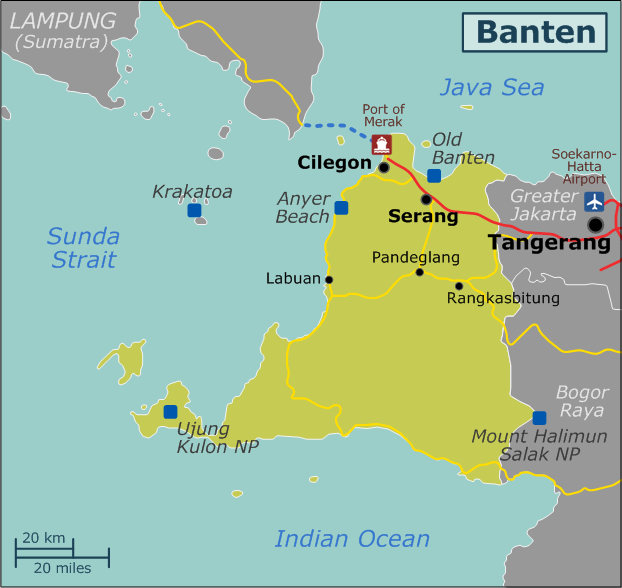
English: Map of Banten region for Wikivoyage. Note that this region does not include all of Banten province! For Wikivoyage, Tangerang city/regency and South Tangerang city are part of the Greater Jakarta region. |
| Date | |
| Source | Own work |
| Author | ErwinFCG |
Licensing edit
I, the copyright holder of this work, hereby publish it under the following license:
This file is licensed under the Creative Commons Attribution-Share Alike 4.0 International license.
- You are free:
- to share – to copy, distribute and transmit the work
- to remix – to adapt the work
- Under the following conditions:
- attribution – You must give appropriate credit, provide a link to the license, and indicate if changes were made. You may do so in any reasonable manner, but not in any way that suggests the licensor endorses you or your use.
- share alike – If you remix, transform, or build upon the material, you must distribute your contributions under the same or compatible license as the original.
File history
Click on a date/time to view the file as it appeared at that time.
| Date/Time | Thumbnail | Dimensions | User | Comment | |
|---|---|---|---|---|---|
| current | 16:35, 30 September 2016 | | 622 × 588 (60 KB) | ErwinFCG (talk | contribs) | added text descriptions to Merak port and Soekarno-Hatta airport. |
| 16:28, 30 September 2016 |  | 622 × 588 (59 KB) | ErwinFCG (talk | contribs) | User created page with UploadWizard |
You cannot overwrite this file.
File usage on Commons
The following page uses this file:
File usage on other wikis
The following other wikis use this file:
- Usage on en.wikivoyage.org