File:Map of Bistrica (Novo Naselje) and Satelit 2010.png

Size of this preview: 779 × 600 pixels. Other resolutions: 312 × 240 pixels | 624 × 480 pixels | 998 × 768 pixels | 1,280 × 986 pixels | 1,430 × 1,101 pixels.
Original file (1,430 × 1,101 pixels, file size: 410 KB, MIME type: image/png)
Captions
Captions
Add a one-line explanation of what this file represents
Summary edit
_and_Satelit_2010.png&action=edit§ion=1)
| Description |
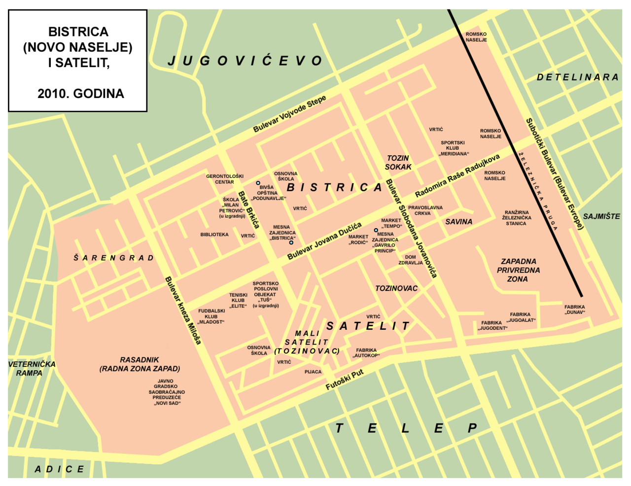
English: Map of Bistrica (Novo Naselje) and Satelit neighborhoods of Novi Sad (as of 2010) - in Serbian language. Српски / srpski: Mapa novosadskih kvartova Bistrice (Novog Naselja) i Satelita (2010. godine) - na srpskom jeziku. |
| Date | |
| Source | Own work |
| Author | PANONIAN |
Licensing edit
_and_Satelit_2010.png&action=edit§ion=2)
| I, the copyright holder of this work, release this work into the public domain. This applies worldwide. In some countries this may not be legally possible; if so: I grant anyone the right to use this work for any purpose, without any conditions, unless such conditions are required by law. |
References edit
_and_Satelit_2010.png&action=edit§ion=3)
- Jovan Mirosavljević, Brevijar ulica Novog Sada 1745-2001, Novi Sad, 2002.
- Jovan Mirosavljević, Novi Sad - atlas ulica, Novi Sad, 1998.
- Zoran Rapajić, Novi Sad bez tajni, Beograd, 2002.
- Novi Sad - plan grada, Magic Map, Smederevska Palanka.
- Novi Sad - plan grada, Marketprint, Novi Sad, 2001.
- http://www.bgnekretnine.net/img/mapa-novi-sad.gif
- http://www.hoteli-srbije.co.rs/hoteli-novi-sad/mape/grad-novi-sad-mapa.jpg
- http://www.nekretnine.rs/site/venus/20090718-mapa-stana-jpg-a238.jpg
- http://www.angro-impex.com/images/novisad-mapa2.jpg
- http://maps.google.com/ - detailed satellite image of Novo Naselje
File history
Click on a date/time to view the file as it appeared at that time.
| Date/Time | Thumbnail | Dimensions | User | Comment | |
|---|---|---|---|---|---|
| current | 17:04, 26 November 2010 | | 1,430 × 1,101 (410 KB) | PANONIAN (talk | contribs) | Better solution for location of Tozinovac |
| 08:47, 18 May 2010 |  | 1,430 × 1,101 (427 KB) | PANONIAN (talk | contribs) | some corrections | |
| 08:47, 14 May 2010 |  | 1,430 × 1,101 (419 KB) | PANONIAN (talk | contribs) | {{Information |Description={{en|1=Map of Bistrica (Novo Naselje) and Satelit neighborhoods of Novi Sad (as of 2010) - in Serbian language.}} |Source={{own}} |Author=PANONIAN |Date= |Permission= |other_versions= }} |
You cannot overwrite this file.
File usage on Commons
The following page uses this file:
File usage on other wikis
The following other wikis use this file:
- Usage on en.wikipedia.org
- Usage on es.wikipedia.org
- Usage on fr.wikipedia.org
- Usage on ja.wikipedia.org
- Usage on sh.wikipedia.org
- Usage on sr.wikipedia.org
_and_Satelit_2010.png&oldid=601457673)