File:Map of Botetourt County LOC 2012591107.tif

Size of this JPG preview of this TIF file: 701 × 600 pixels. Other resolutions: 281 × 240 pixels | 561 × 480 pixels | 898 × 768 pixels | 1,197 × 1,024 pixels | 2,394 × 2,048 pixels | 9,215 × 7,885 pixels.
Original file (9,215 × 7,885 pixels, file size: 207.88 MB, MIME type: image/tiff)
Captions
Captions
Add a one-line explanation of what this file represents
Summary edit
| Description |
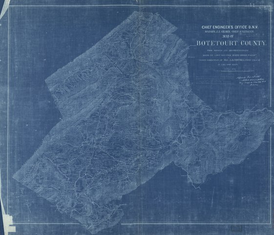
English: Relief shown by hachures. Shows the names of some residents. Oriented with north toward upper right. Blue-line print. "Map from the Confederate Engineer Bureau in Richmond, Va. General J.F. Gilmer chief engineer. Presented to the West Point Military Academy by his only daughter, Mrs. J.F. Minis, Savh., Ga." "Approved Feb. 16th 1865 Albert H. Campbell, Maj. Engr. in chage Top. Dep. D.N.Va." LC Land ownership maps, 1222 "Gilmer maps no. 11." Signed in lower left corner: Mrs. J.F. Gilmer. Available also through the Library of Congress Web site as a raster image. |
||
| Title | Map of Botetourt County | ||
| Shelf ID | G3883.B6G46 1865 .I9 | ||
| Date | |||
| Source | https://www.loc.gov/item/2012591107/ | ||
| Author | Izard, Walter; Campbell, Albert H. (Albert Henry); Gilmer, Jeremy Francis; Minis, Louisa Porter; Confederate States Of America. Army. Department Of Northern Virginia; United States Military Academy | ||
| Permission (Reusing this file) |
|
||
| Other versions |
|
||
| Location | United States · Botetourt County · Virginia | ||
| Part of | American Memory · Catalog · County Landownership Maps · Geography And Map Division · Cultural Landscapes | ||
| Subject | Cadastral Maps · Botetourt County · Virginia · Botetourt County (Va.) · United States · Maps · Real Property · Landowners |


Licensing edit
|
This is a faithful photographic reproduction of a two-dimensional, public domain work of art. The work of art itself is in the public domain for the following reason:
The official position taken by the Wikimedia Foundation is that "faithful reproductions of two-dimensional public domain works of art are public domain".
This photographic reproduction is therefore also considered to be in the public domain in the United States. In other jurisdictions, re-use of this content may be restricted; see Reuse of PD-Art photographs for details. | ||||
File history
Click on a date/time to view the file as it appeared at that time.
| Date/Time | Thumbnail | Dimensions | User | Comment | |
|---|---|---|---|---|---|
| current | 13:42, 21 May 2018 |  | 9,215 × 7,885 (207.88 MB) | Fæ (talk | contribs) | LOC Maps https://www.loc.gov/item/2012591107/ #12880 |
You cannot overwrite this file.
File usage on Commons
The following page uses this file: