File:Map of Churchill Harbour by Jens Munck 1624 (1897).jpg

Original file (2,216 × 1,679 pixels, file size: 2.36 MB, MIME type: image/jpeg)
Captions
Captions
Summary edit
| Description |
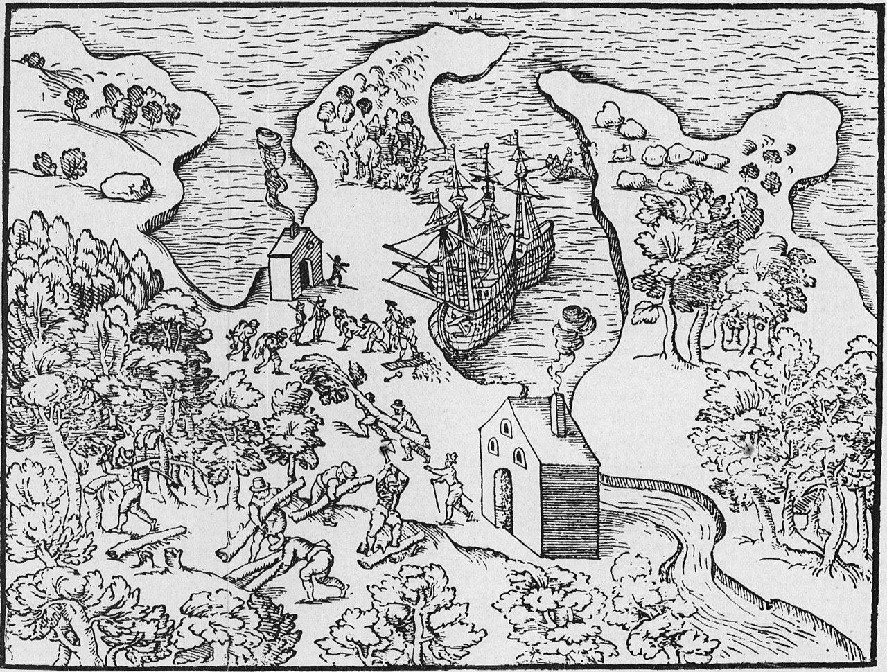
Munck, Jens. [Map of Churchill Harbour 1624] [facisimle]. [1:107,712]. In: C.C.A. Gosch. The Expedition of Captain Jens Munk to Hudson's Bay in Search of a North-West Passage in 1619-20. London: Hakluyt Society, 1897. As reproduced by, Hakluyt Society, Danish Arctic Expeditions, 1605 to 1620, Book II, vol. 97. Munck's wintering place is depicted in this interesting woodcut, which combines pictorial representation of the countryside and of activities, with a stylized map of Churchill harbour. This is the first large-scale map of a Manitoba locale. Munck's two ships are anchored off their wintering place on the west side of the harbour. Two beacons are being stoked with logs cut from the nearby forests, two sailors return from the hunt with their kill over their shoulders, and one unfortunate crew member is being prepared for burial, likely one of the victims of the scurvy. The felling of timber, a continuous necessity, is the beginning of the process which was followed by all later inhabitants, and which denuded the countryside for miles back from the site. The shape of the harbour with its encircling arms is properly, though crudely, represented and its axis is correctly oriented north to south. (Warkentin and Ruggles. Historical Atlas of Manitoba. map 4, p. 24) Original manuscript and map in University Library, Copenhagen, (MS. Additamenta, No. 184) |
||
| Date | |||
| Source | Map of Churchill Harbour by Jens Munck 1624 (1897) | ||
| Author | Manitoba Historical Maps | ||
| Other versions |
|
_-_5_fig_3_-_Winter_Harbour_at_Churchill_River_-_1_full.png)
.jpg&action=edit§ion=1)
| Camera location | | View this and other nearby images on: OpenStreetMap |
|---|
.jpg¶ms=058.752531_N_-094.236602_E_globe:Earth_type:camera_source:Flickr_&language=en)
Licensing edit
.jpg&action=edit§ion=2)
- You are free:
- to share – to copy, distribute and transmit the work
- to remix – to adapt the work
- Under the following conditions:
- attribution – You must give appropriate credit, provide a link to the license, and indicate if changes were made. You may do so in any reasonable manner, but not in any way that suggests the licensor endorses you or your use.
| This image was originally posted to Flickr by Manitoba Historical Maps at https://www.flickr.com/photos/11496488@N07/1128393743. It was reviewed on 25 June 2011 by FlickreviewR and was confirmed to be licensed under the terms of the cc-by-2.0. |
File history
Click on a date/time to view the file as it appeared at that time.
| Date/Time | Thumbnail | Dimensions | User | Comment | |
|---|---|---|---|---|---|
| current | 15:17, 25 June 2011 | | 2,216 × 1,679 (2.36 MB) | FlickreviewR (talk | contribs) | Replacing image by its original image from Flickr |
| 14:44, 25 June 2011 |  | 500 × 379 (153 KB) | Geo Swan (talk | contribs) | {{Information |Description=Munck, Jens. [Map of Churchill Harbour 1624] [facisimle]. [1:107,712]. In: C.C.A. Gosch. The Expedition of Captain Jens Munk to Hudson's Bay in Search of a North-West Passage in 1619-20. London: Hakluyt Society, 1897. As reprodu |
You cannot overwrite this file.
File usage on Commons
The following page uses this file:
File usage on other wikis
The following other wikis use this file:
- Usage on ca.wikipedia.org
- Usage on fr.wikipedia.org
- Usage on nl.wikipedia.org
.jpg&oldid=665885240)