File:Map of Fitz Roy massif - 01.svg

Size of this PNG preview of this SVG file: 564 × 599 pixels. Other resolutions: 226 × 240 pixels | 452 × 480 pixels | 723 × 768 pixels | 964 × 1,024 pixels | 1,928 × 2,048 pixels | 5,081 × 5,396 pixels.
Original file (SVG file, nominally 5,081 × 5,396 pixels, file size: 1.03 MB)
Captions
Captions
Add a one-line explanation of what this file represents
Summary edit
| Description |
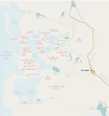
Français : Carte du massif du Fitz Roy, réalisée à partir des données d'Open Street Map (openstreetmap.org).
|
| Date | |
| Source | openstreetmap.org |
| Author | Gagea |
Licensing edit
| Description |
This map was created from OpenStreetMap project data, collected by the community. This map may be incomplete, and may contain errors. Don't rely solely on it for navigation. |
| Date | (see file history) |
| Source | openstreetmap.org |
| Creator |
OpenStreetMap contributors |
| Permission (Reusing this file) |
OpenStreetMap data and maps are licensed under the Creative Commons Attribution-ShareAlike 2.0 license (CC-BY-SA 2.0). This file is licensed under the Creative Commons Attribution-Share Alike 2.0 Generic license.
|
| Georeferencing | If inappropriate please set warp_status = skip to hide. |
File history
Click on a date/time to view the file as it appeared at that time.
| Date/Time | Thumbnail | Dimensions | User | Comment | |
|---|---|---|---|---|---|
| current | 23:19, 27 March 2010 | | 5,081 × 5,396 (1.03 MB) | Gagea (talk | contribs) | {{Information |Description={{fr|1=Carte du massif du Fitz Roy, réalisée à partir des données d'Open Street Map (openstreetmap.org). * Légende: ** triangles marrons: sommet ** pointillés rouge: chemins de randonnées ** lignes bleues: cours d'eau ** |
You cannot overwrite this file.
File usage on Commons
The following page uses this file:
File usage on other wikis
The following other wikis use this file:
- Usage on fr.wikipedia.org