File:Map of Grand River, Ontario.png
Original file (514 × 705 pixels, file size: 10 KB, MIME type: image/png)
Captions
Captions
Original caption from English Wikipedia follows:
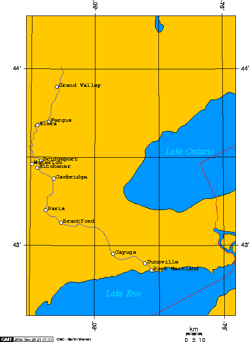
Map of the Grand River, in Ontario Canada edit
I created this map of the Grand River, in Ontario Canada. I used this cool online map creation tool. I own the copyright on this image. And I liscense it under the GNU Free Documentation License.
I used an online gazetteer to look up the latitude and longitude of the cities on my map. That site, the GeoNET Name Server, said the output from their tool was free to use. But they requested users cite their usage as follows:
Toponymic information is based on the Geographic Names Data Base, containing official standard names approved by the United States Board on Geographic Names and maintained by the National Geospatial-Intelligence Agency. More information is available at the Products and Services link at www.nga.mil. Geo Swan 22:26, 29 Oct 2004 (UTC)
Here are the longitudes and latitudes I used to create this map:
- -80.30,43.90,w:Grand Valley
- -80.362,43.70,Fergus
- -80.45,43.68,Elora
- -80.49,43.46,Waterloo
- -80.42,43.48,Bridgeport
- -80.45,43.44,Kitchener
- -80.32,43.38,Cambridge
- -80.38,43.20,Paris
- -80.26,43.13,Brantford
- -79.8573,42.9538,Cayuga
- -79.61,42.90,Dunnville
- -79.56,42.86,Port Maitland
| I, the copyright holder of this work, release this work into the public domain. This applies worldwide. In some countries this may not be legally possible; if so: I grant anyone the right to use this work for any purpose, without any conditions, unless such conditions are required by law. |

|
Permission is granted to copy, distribute and/or modify this document under the terms of the GNU Free Documentation License, Version 1.2 or any later version published by the Free Software Foundation; with no Invariant Sections, no Front-Cover Texts, and no Back-Cover Texts. A copy of the license is included in the section entitled GNU Free Documentation License. |
| This file is licensed under the Creative Commons Attribution-Share Alike 3.0 Unported license. | ||
| Attribution: Geo_Swan | ||
| ||
| This licensing tag was added to this file as part of the GFDL licensing update. |
- You are free:
- to share – to copy, distribute and transmit the work
- to remix – to adapt the work
- Under the following conditions:
- attribution – You must give appropriate credit, provide a link to the license, and indicate if changes were made. You may do so in any reasonable manner, but not in any way that suggests the licensor endorses you or your use.
- share alike – If you remix, transform, or build upon the material, you must distribute your contributions under the same or compatible license as the original.
File history
Click on a date/time to view the file as it appeared at that time.
| Date/Time | Thumbnail | Dimensions | User | Comment | |
|---|---|---|---|---|---|
| current | 18:15, 3 February 2008 | | 514 × 705 (10 KB) | Balcer~commonswiki (talk | contribs) | Original caption from English Wikipedia follows: == Map of the Grand River, in Ontario Canada == I created this map of the Grand River, in Ontario Canada. I used [http://www.aquarius.geomar.de/omc_bg_info.html this cool online map creation |
You cannot overwrite this file.
File usage on Commons
The following 2 pages use this file:
- File:GPLed Grand River.png (file redirect)
- Category:Grand River (Ontario)
File usage on other wikis
The following other wikis use this file:
- Usage on ar.wikipedia.org
- Usage on arz.wikipedia.org
- Usage on ceb.wikipedia.org
- Usage on de.wikipedia.org
- Usage on en.wikipedia.org
- Usage on fr.wikipedia.org
- Usage on it.wikipedia.org
- Usage on pl.wikipedia.org
- Usage on pt.wikipedia.org
- Usage on ru.wikipedia.org
- Usage on sv.wikipedia.org
- Usage on uk.wikipedia.org
- Usage on www.wikidata.org
- Usage on zh.wikipedia.org