File:Map of Great Brewster Island, Boston Harbor, showing the abrasion from 1820 to 1851 inclusive (7557361856).jpg

Size of this preview: 800 × 432 pixels. Other resolutions: 320 × 173 pixels | 640 × 346 pixels | 1,024 × 553 pixels | 1,280 × 692 pixels | 2,560 × 1,383 pixels | 4,965 × 2,683 pixels.
Original file (4,965 × 2,683 pixels, file size: 12.13 MB, MIME type: image/jpeg)
Captions
Captions
Add a one-line explanation of what this file represents
Summary edit
.jpg&action=edit§ion=1)
| Description |
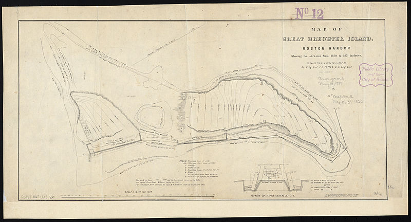
Zoom into this map at maps.bpl.org. Author: Boston (Mass.). City Council. Joint Standing Committee on Boston Harbor. Date: 1820 Location: Boston Harbor Islands (Mass.), Great Brewster Island (Mass.) Dimension 21 x 41 cm. Scale: 1:1,800 Call Number: G3762.B67 1820 .B6 |
| Date | |
| Source |
Map of Great Brewster Island, Boston Harbor, showing the abrasion from 1820 to 1851 inclusive
|
| Author | http://maps.bpl.org |
Licensing edit
.jpg&action=edit§ion=2)
This file is licensed under the Creative Commons Attribution 2.0 Generic license.
- You are free:
- to share – to copy, distribute and transmit the work
- to remix – to adapt the work
- Under the following conditions:
- attribution – You must give appropriate credit, provide a link to the license, and indicate if changes were made. You may do so in any reasonable manner, but not in any way that suggests the licensor endorses you or your use.
| This image, originally posted to Flickr, was reviewed on 21 August 2013 by the administrator or reviewer File Upload Bot (Magnus Manske), who confirmed that it was available on Flickr under the stated license on that date. |
File history
Click on a date/time to view the file as it appeared at that time.
| Date/Time | Thumbnail | Dimensions | User | Comment | |
|---|---|---|---|---|---|
| current | 03:58, 21 August 2013 | | 4,965 × 2,683 (12.13 MB) | File Upload Bot (Magnus Manske) (talk | contribs) | Transferred from Flickr by User:tm |
You cannot overwrite this file.
File usage on Commons
There are no pages that use this file.
.jpg&oldid=758240635)