File:Map of Iranian Azerbaijan 1945-46 insurgency by Robert Rossow.svg

Size of this PNG preview of this SVG file: 800 × 536 pixels. Other resolutions: 320 × 214 pixels | 640 × 429 pixels | 1,024 × 686 pixels | 1,280 × 857 pixels | 2,560 × 1,714 pixels | 1,498 × 1,003 pixels.
Original file (SVG file, nominally 1,498 × 1,003 pixels, file size: 843 KB)
Captions
Captions
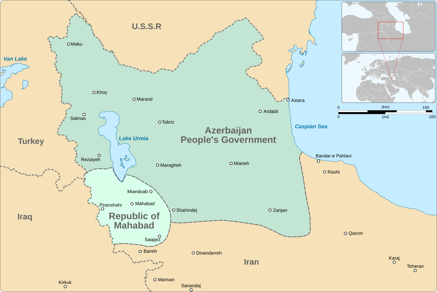
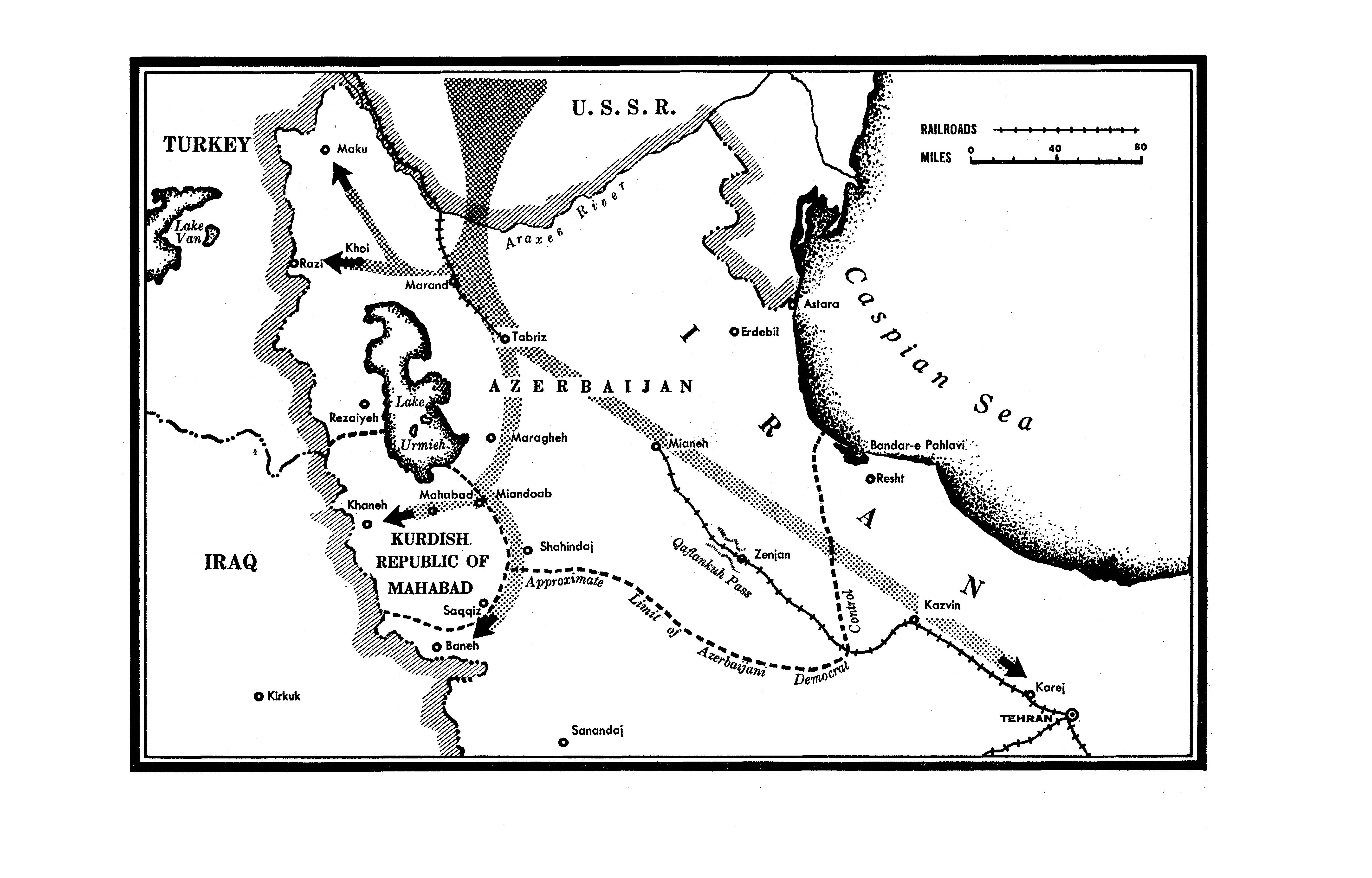
Map of Iranian Azerbaijan during 1945-1946
Summary
edit| Description |
English: Map of Iranian Azerbaijan during 1945-1946, when it was occupied by the Red Army and the Soviet puppet states named Republic of Mahabad and People's Government of Azerbaijan. Boundaries are approximate and based on a work by Robert Rossow Jr., an American diplomat stationed in Tabriz.
|
|||||||||||||||||||||||||||||||||||||||||||||||||||
| Date | ||||||||||||||||||||||||||||||||||||||||||||||||||||
| Source |
Own work based on: |
|||||||||||||||||||||||||||||||||||||||||||||||||||
| Author | Goran_tek-en | |||||||||||||||||||||||||||||||||||||||||||||||||||
| Permission (Reusing this file) |
This file is licensed under the Creative Commons Attribution-Share Alike 4.0 International license. Attribution: Goran_tek-en
|
|||||||||||||||||||||||||||||||||||||||||||||||||||
| Other versions |
|
|||||||||||||||||||||||||||||||||||||||||||||||||||
| SVG development | This vector image was created with Inkscape. |
|||||||||||||||||||||||||||||||||||||||||||||||||||
_-_Near_Saraeyn_-_Iranian_Azerbaijan_-_Iran_(7421215180).jpg)


| Object location | | View this and other nearby images on: OpenStreetMap |
|---|
File history
Click on a date/time to view the file as it appeared at that time.
| Date/Time | Thumbnail | Dimensions | User | Comment | |
|---|---|---|---|---|---|
| current | 07:39, 11 June 2024 | | 1,498 × 1,003 (843 KB) | Balyozxane (talk | contribs) | File uploaded using svgtranslate tool (https://svgtranslate.toolforge.org/). Added translation for ku-latn. |
| 19:20, 15 September 2023 |  | 1,498 × 1,003 (812 KB) | HeminKurdistan (talk | contribs) | Reverted to version as of 18:42, 15 September 2023 (UTC). This is not "minor", upload your own file if you want. | |
| 18:52, 15 September 2023 |  | 1,498 × 1,003 (878 KB) | Golden (talk | contribs) | Reverted to version as of 18:19, 15 September 2023 (UTC) That policy does not apply to minor edits, which this was. Check the original source and see for yourself which version had more accurate borders | |
| 18:42, 15 September 2023 |  | 1,498 × 1,003 (812 KB) | HeminKurdistan (talk | contribs) | Reverted to version as of 18:00, 27 February 2023 (UTC) per Commons:Overwriting existing files | |
| 18:19, 15 September 2023 |  | 1,498 × 1,003 (878 KB) | Golden (talk | contribs) | making borders more accurate per the source | |
| 18:00, 27 February 2023 |  | 1,498 × 1,003 (812 KB) | Goran tek-en (talk | contribs) | Moved one city name | |
| 17:49, 27 February 2023 |  | 1,498 × 1,003 (813 KB) | Goran tek-en (talk | contribs) | {{Information |description ={{en|Map of Iranian Azerbaijan during 1945-1946, when it was occupied by the Red Army and the Soviet puppet states named Republic of Mahabad and People's Government of Azerbaijan. Boundaries are approximate and based on a work by Robert Rossow Jr., an American diplomat stationed in Tabriz.}} {{Institution |wikidata=Q274536}} {{Institution |wikidata=Q332232}} {{Institution |wikidata=Q2305337}} {{Institution |wikidata=Q1132835}} |date =2023-02-27... |
You cannot overwrite this file.
File usage on Commons
The following 3 pages use this file:
.svg)
.svg)