File:Map of King William County LOC 2012589213.jpg

Size of this preview: 800 × 536 pixels. Other resolutions: 320 × 215 pixels | 640 × 429 pixels | 1,024 × 686 pixels | 1,280 × 858 pixels | 2,560 × 1,716 pixels | 9,991 × 6,698 pixels.
Original file (9,991 × 6,698 pixels, file size: 8.08 MB, MIME type: image/jpeg)
Captions
Captions
Add a one-line explanation of what this file represents
Summary edit
| Description |
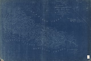
English: Relief shown by hachures. Shows the names of some residents. Oriented with north toward upper left. At head of title: Maj. Gen. J.F. Gilmer Chief Engineer. "Property of Mrs. J.F. Gilmer 126 State Street Savannah Geo To be returned to her." "Approved March 7, 1865 Albert H. Campbell Maj Engrs in chge Top Dep D.N.V." Blueprint. LC Land ownership maps, 1286 Available also through the Library of Congress Web site as a raster image. "Map from the Confederate Engineer Bureau in Richmond, Va. General J.F. Gilmer, Chief Engineer - Presented to - the West Point Military Academy by his only daughter, Mrs. J.F. Minis, Savannah, GA." This county contains 310 square miles. The lines of the Rivers as far as practicable were run by Instrument and the houses on the opposite sides were established by intersecting sites." Stamped in blue ink on verso: By transfer U.S. Military Academy, Oct. 4, 1929. |
||
| Title | Map of King William County | ||
| Shelf ID | G3883.K6G46 1865 .B4 | ||
| Date | |||
| Source | https://www.loc.gov/item/2012589213/ | ||
| Author | Blackford, L. (Benjamin Lewis); Gilmer, Jeremy Francis; Campbell, Albert H. (Albert Henry); Minis, Louisa Porter; Confederate States Of America. Army. Department Of Northern Virginia. Chief Engineer'S Office; United States Military Academy; Blackford, L. | ||
| Permission (Reusing this file) |
|
||
| Other versions |
|
||
| Location | United States · King William County · Virginia | ||
| Part of | American Memory · Catalog · County Landownership Maps · Geography And Map Division · Cultural Landscapes | ||
| Subject | Cadastral Maps · King William County · King William County (Va.) · Virginia · United States · Maps · Landowners |


Licensing edit
|
This is a faithful photographic reproduction of a two-dimensional, public domain work of art. The work of art itself is in the public domain for the following reason:
The official position taken by the Wikimedia Foundation is that "faithful reproductions of two-dimensional public domain works of art are public domain".
This photographic reproduction is therefore also considered to be in the public domain in the United States. In other jurisdictions, re-use of this content may be restricted; see Reuse of PD-Art photographs for details. | ||||
File history
Click on a date/time to view the file as it appeared at that time.
| Date/Time | Thumbnail | Dimensions | User | Comment | |
|---|---|---|---|---|---|
| current | 23:52, 4 June 2018 | | 9,991 × 6,698 (8.08 MB) | Fæ (talk | contribs) | LOC Maps https://www.loc.gov/item/2012589213/ #20212 |
You cannot overwrite this file.
File usage on Commons
The following page uses this file: