File:Map of Kings and part of Queens counties, Long Island N.Y. LOC 2013593245.tif

Size of this JPG preview of this TIF file: 634 × 599 pixels. Other resolutions: 254 × 240 pixels | 508 × 480 pixels | 812 × 768 pixels | 1,083 × 1,024 pixels | 2,166 × 2,048 pixels | 16,957 × 16,034 pixels.
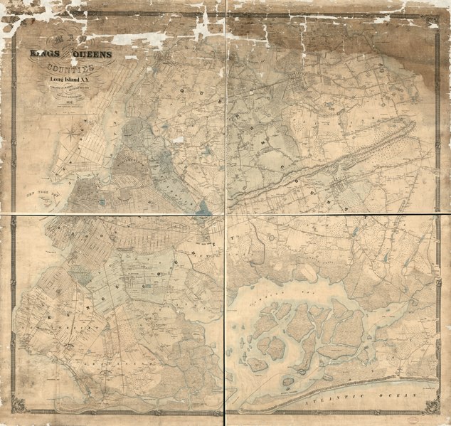
Original file (16,957 × 16,034 pixels, file size: 777.88 MB, MIME type: image/tiff)
Captions
Captions
Add a one-line explanation of what this file represents
Summary edit
| Warning | The original file is very high-resolution. It might not load properly or could cause your browser to freeze when opened at full size. |
|---|
| Description |
English: Covers Brooklyn (Kings County) and the western part of Queens County (now part of New York City). Shows towns (townships), built-up areas, streets system in urban areas, land tracts (with owners' names/acreages) in rural areas, and buildings/houses (with householders' names) in rural areas. Relief shown by hachures. Hand colored to emphasize town territories, parks, cemeteries, watercourses, and coastlines. LC copy imperfect: Darkened, stained in northern areas, brittle, mounted on stiff paper backing, missing numerous small sections (especially in northern area), Includes 2-mile bar "Scale of chains". Available also through the Library of Congress Web site as a raster image. |
||
| Title | Map of Kings and part of Queens counties, Long Island N.Y. | ||
| Shelf ID | G3804.N4:3B8G46 1852 .C6 | ||
| Date | |||
| Source | https://www.loc.gov/item/2013593245/ | ||
| Author | Conner, R. F. O.; Dripps, M. (Matthew); Korff Brothers | ||
| Permission (Reusing this file) |
|
||
| Other versions |
|
||
| Location | Queens (New York) · Brooklyn (New York) · United States · Brooklyn · New York · New York (State) · Queens | ||
| Part of | American Memory · Catalog · County Landownership Maps · Geography And Map Division · Cultural Landscapes | ||
| Subject | Cadastral Maps · Queens (New York) · Queens (New York, N.Y.) · Brooklyn (New York) · United States · Maps · New York · Brooklyn (New York, N.Y.) · Real Property · New York (State) · Landowners |


Licensing edit
|
This is a faithful photographic reproduction of a two-dimensional, public domain work of art. The work of art itself is in the public domain for the following reason:
The official position taken by the Wikimedia Foundation is that "faithful reproductions of two-dimensional public domain works of art are public domain".
This photographic reproduction is therefore also considered to be in the public domain in the United States. In other jurisdictions, re-use of this content may be restricted; see Reuse of PD-Art photographs for details. | ||||
File history
Click on a date/time to view the file as it appeared at that time.
| Date/Time | Thumbnail | Dimensions | User | Comment | |
|---|---|---|---|---|---|
| current | 06:18, 19 June 2018 |  | 16,957 × 16,034 (777.88 MB) | Fæ (talk | contribs) | LOC Maps https://www.loc.gov/item/2013593245/ #20436 |
You cannot overwrite this file.
File usage on Commons
The following page uses this file: