File:Map of Long Island with the environs of New-York and the southern part of Connecticut - compiled from various surveys and documents by J. Calvin Smith; engraved and printed by S. Stiles and NYPL434771.tiff

Size of this JPG preview of this TIF file: 800 × 539 pixels. Other resolutions: 320 × 216 pixels | 640 × 431 pixels | 1,024 × 690 pixels | 1,280 × 862 pixels | 2,560 × 1,724 pixels | 7,943 × 5,350 pixels.

Original file (7,943 × 5,350 pixels, file size: 121.6 MB, MIME type: image/tiff, 2 pages)
Captions
Captions
Add a one-line explanation of what this file represents
Summary edit
| Description | Map of Long Island with the environs of New-York and the southern part of Connecticut / compiled from various surveys and documents by J. Calvin Smith ; engraved and printed by S. Stiles and Co., N. York.; Maps of New York City and State / Parts / Long Island | |||||||||||||||||||||||
| Notes | "Entered according to Act of Congress, in the year 1836 by J.H. Colton and Co. in the Clerks Office of the District Court of the Southern District of New York." ''Note 2.'') Includes decorative border and notes. Also includes view of New-Brighton. ''Note 3.'') Insets: City of New Haven -- New Brighton, Tompkinsville and the adjoining grounds, Richmond Co., Staten-Island -- City of Newark, Essex Co., New Jersey -- Plan of Brooklyn and Williamsburgh. ''Note 4.'') National Endowment for the Humanities Grant for Access to Early Maps of the Middle Atlantic Seaboard. ''Note 5.'') Relief shown by hachures. ''Note 6.'') Shows boundaries of states, counties and towns. | |||||||||||||||||||||||
| Item physical description | 1 map on 3 sheets : hand col. ; 84 x 131 cm., sheets 96 x 51 cm., or smaller. | |||||||||||||||||||||||
| Catalogue call number | Map Div. 01-1930 | |||||||||||||||||||||||
| Date | ||||||||||||||||||||||||
| Source |
http://digitalgallery.nypl.org/nypldigital/dgkeysearchdetail.cfm?imageID=1952221
|
|||||||||||||||||||||||
| Author | J. Calvin (John Calvin) -- Compiler Smith | |||||||||||||||||||||||
| Permission (Reusing this file) |
From The Lionel Pincus and Princess Firyal Map Division. http://maps.nypl.org
|
|||||||||||||||||||||||
| Location | Stephen A. Schwarzman Building / The Lionel Pincus and Princess Firyal Map Division | |||||||||||||||||||||||
| Digital item published | 2-3-2004; updated 1-9-2012 | |||||||||||||||||||||||
| Digital ID | 434771 | |||||||||||||||||||||||

The making of this file was supported by Wikimedia UK.
To see other files made with the support of Wikimedia UK, please see the category Supported by Wikimedia UK.
|
File history
Click on a date/time to view the file as it appeared at that time.
| Date/Time | Thumbnail | Dimensions | User | Comment | |
|---|---|---|---|---|---|
| current | 02:30, 21 April 2015 |  | 7,943 × 5,350, 2 pages (121.6 MB) | Tm (talk | contribs) | Reverted to version as of 00:53, 10 May 2014 |
| 00:54, 10 May 2014 |  | 10,984 × 7,945 (249.7 MB) | Fæ (talk | contribs) | GWToolset: Creating mediafile for Fæ. Tranche 4 -12906 @11:45 BST, 9 May 2014 | |
| 00:53, 10 May 2014 |  | 7,943 × 5,350 (121.6 MB) | Fæ (talk | contribs) | GWToolset: Creating mediafile for Fæ. Tranche 4 -12906 @11:45 BST, 9 May 2014 | |
| 00:53, 10 May 2014 | 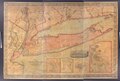 | 7,943 × 5,350 (121.6 MB) | Fæ (talk | contribs) | GWToolset: Creating mediafile for Fæ. Tranche 4 -12906 @11:45 BST, 9 May 2014 |
You cannot overwrite this file.
File usage on Commons
There are no pages that use this file.