File:Map of Lydia ancient times-eo.svg

Size of this PNG preview of this SVG file: 400 × 277 pixels. Other resolutions: 320 × 222 pixels | 640 × 443 pixels | 1,024 × 709 pixels | 1,280 × 886 pixels | 2,560 × 1,773 pixels.
Original file (SVG file, nominally 400 × 277 pixels, file size: 47 KB)
Captions
Captions
Add a one-line explanation of what this file represents
Summary edit
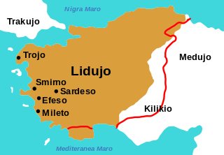
| Description |
Deutsch: Der Rand der braunen Fläche ist die Grenze Lydiens in der Mitte des 6. Jahrhunderts v. Chr. Die rote Linie ist eine andere mögliche Grenze Lydiens.
English: The edge of the brown area is the border of Lydia at the middle of the 6th century BC. The red line is a possible different border of Lydia.
Esperanto: La rando de la bruno estas la limo de Lidujo en la mezo de la 6-a jarcento a. K. La ruĝa linio estas alia ebla limo de Lidujo. |
| Date | |
| Source |
File:Map of Lydia ancient times-en.svg "
|
| Author | Original: User:Roke~commonswiki; svg: User:Nekto; File:Map of Lydia ancient times-en.svg: User:WillemBK; translation/traduko: User:KEO144000 |
| Other versions |
[]
|


Licensing edit
This file is licensed under the Creative Commons Attribution-Share Alike 3.0 Unported license.
- You are free:
- to share – to copy, distribute and transmit the work
- to remix – to adapt the work
- Under the following conditions:
- attribution – You must give appropriate credit, provide a link to the license, and indicate if changes were made. You may do so in any reasonable manner, but not in any way that suggests the licensor endorses you or your use.
- share alike – If you remix, transform, or build upon the material, you must distribute your contributions under the same or compatible license as the original.
File history
Click on a date/time to view the file as it appeared at that time.
| Date/Time | Thumbnail | Dimensions | User | Comment | |
|---|---|---|---|---|---|
| current | 12:30, 17 June 2016 | | 400 × 277 (47 KB) | KEO144000 (talk | contribs) | User created page with UploadWizard |
You cannot overwrite this file.
File usage on Commons
The following 22 pages use this file:
- File:Map of Lydia ancient times-2.jpg
- File:Map of Lydia ancient times-als.svg
- File:Map of Lydia ancient times-de.svg
- File:Map of Lydia ancient times-el.svg
- File:Map of Lydia ancient times-en.svg
- File:Map of Lydia ancient times-eo.svg
- File:Map of Lydia ancient times-es.svg
- File:Map of Lydia ancient times-fy.svg
- File:Map of Lydia ancient times-hy.svg
- File:Map of Lydia ancient times-it.svg
- File:Map of Lydia ancient times-ja.svg
- File:Map of Lydia ancient times-ko.svg
- File:Map of Lydia ancient times-la.svg
- File:Map of Lydia ancient times-nl.svg
- File:Map of Lydia ancient times-pt.svg
- File:Map of Lydia ancient times-ru.svg
- File:Map of Lydia ancient times-zh-classical.png
- File:Map of Lydia ancient times.jpg
- File:Map of Lydia ancient times be.svg
- File:Map of Lydia ancient times fa.svg
- File:Map of Lydia ancient times tr.jpg
- Template:Other versions/Map of Lydia ancient times
File usage on other wikis
The following other wikis use this file:
- Usage on eo.wikipedia.org