File:Map of Missouri highlighting Saint Louis County.svg

Size of this PNG preview of this SVG file: 682 × 600 pixels. Other resolutions: 273 × 240 pixels | 546 × 480 pixels | 874 × 768 pixels | 1,165 × 1,024 pixels | 2,329 × 2,048 pixels | 5,812 × 5,110 pixels.
Original file (SVG file, nominally 5,812 × 5,110 pixels, file size: 112 KB)
Captions
Captions
Add a one-line explanation of what this file represents
Summary edit
| Description |
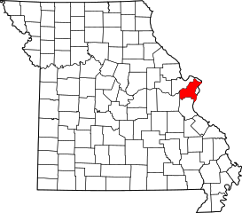
English: This is a locator map showing Saint Louis County in Missouri. For more information, see Commons:United States county locator maps. |
| Date | |
| Source |
Own work: English: The maps use data from nationalatlas.gov, specifically countyp020.tar.gz on the Raw Data Download page. The maps also use state outline data from statesp020.tar.gz. The Florida maps use hydrogm020.tar.gz to display Lake Okeechobee. |
| Author | David Benbennick |
Licensing edit
| I, the copyright holder of this work, release this work into the public domain. This applies worldwide. In some countries this may not be legally possible; if so: I grant anyone the right to use this work for any purpose, without any conditions, unless such conditions are required by law. |
File history
Click on a date/time to view the file as it appeared at that time.
| Date/Time | Thumbnail | Dimensions | User | Comment | |
|---|---|---|---|---|---|
| current | 13:28, 12 February 2006 | | 5,812 × 5,110 (112 KB) | David Benbennick (talk | contribs) | {{subst:User:Dbenbenn/clm|county=Saint Louis County|state=Missouri|type=county}} |
You cannot overwrite this file.
File usage on Commons
The following 7 pages use this file:
- Category:Births in St. Louis County, Missouri
- Category:Deaths in St. Louis County, Missouri
- Category:Geography of St. Louis County, Missouri
- Category:Maps of St. Louis County, Missouri
- Category:People of St. Louis County, Missouri
- Category:Populated places in St. Louis County, Missouri
- Category:St. Louis County, Missouri
File usage on other wikis
The following other wikis use this file:
- Usage on ar.wikipedia.org
- Usage on arz.wikipedia.org
- Usage on cdo.wikipedia.org
- Usage on ceb.wikipedia.org
- Usage on ce.wikipedia.org
- Usage on cy.wikipedia.org
- Usage on de.wikipedia.org
- Liste der Countys in Missouri
- St. Louis County (Missouri)
- Clayton (Missouri)
- Kirkwood (Missouri)
- Chesterfield (Missouri)
- Florissant
- Hazelwood (Missouri)
- Black Jack (Missouri)
- Eureka (Missouri)
- Ladue
- Edmundson
- Spanish Lake (Missouri)
- Vorlage:Navigationsleiste Orte im St. Louis County
- Ballwin
- Manchester (Missouri)
- Bellefontaine Neighbors
- Oakville (Missouri)
- Wildwood (Missouri)
- University City
- Mehlville
- Maryland Heights
- Webster Groves
- Ferguson (Missouri)
- Affton
- Liste der Einträge im National Register of Historic Places im St. Louis County (Missouri)
- Creve Coeur (Missouri)
- Town and Country (Missouri)
- Bridgeton (Missouri)
- Green Park (Missouri)
- Crestwood (Missouri)
- Winchester (Missouri)
- Ellisville (Missouri)
- Jennings (Missouri)
- St. Ann (Missouri)
- Oakland (Missouri)
- Overland (Missouri)
- Lakeshire (Missouri)
- Woodson Terrace (Missouri)
- Bella Villa
- Berkeley (Missouri)
- Beverly Hills (Missouri)
- Breckenridge Hills
- Brentwood (Missouri)
- Charlack
View more global usage of this file.