File:Map of New Jersey highlighting Somerset County.svg

Size of this PNG preview of this SVG file: 316 × 598 pixels. Other resolutions: 127 × 240 pixels | 253 × 480 pixels | 405 × 768 pixels | 541 × 1,024 pixels | 1,081 × 2,048 pixels | 1,426 × 2,700 pixels.
Original file (SVG file, nominally 1,426 × 2,700 pixels, file size: 61 KB)
Captions
Captions
Add a one-line explanation of what this file represents
Summary edit
| Description |
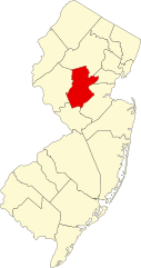
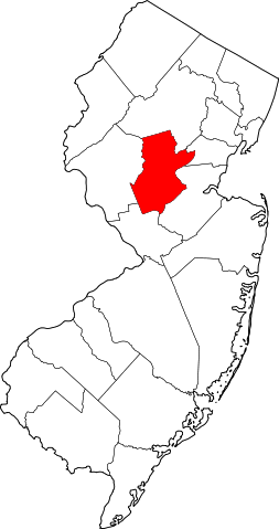
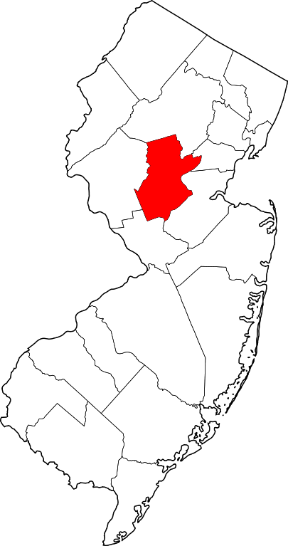
English: This is a locator map showing Somerset County in New Jersey. For more information, see Commons:United States county locator maps. |
| Date | |
| Source |
Own work: English: The maps use data from nationalatlas.gov, specifically countyp020.tar.gz on the Raw Data Download page. The maps also use state outline data from statesp020.tar.gz. The Florida maps use hydrogm020.tar.gz to display Lake Okeechobee. |
| Author | David Benbennick |
Licensing edit
| I, the copyright holder of this work, release this work into the public domain. This applies worldwide. In some countries this may not be legally possible; if so: I grant anyone the right to use this work for any purpose, without any conditions, unless such conditions are required by law. |
File history
Click on a date/time to view the file as it appeared at that time.
| Date/Time | Thumbnail | Dimensions | User | Comment | |
|---|---|---|---|---|---|
| current | 15:29, 12 February 2006 | | 1,426 × 2,700 (61 KB) | David Benbennick (talk | contribs) | {{subst:User:Dbenbenn/clm|county=Somerset County|state=New Jersey|type=county}} |
You cannot overwrite this file.
File usage on Commons
The following 9 pages use this file:
- File:Somerset County New Jersey.png
- Category:Births in Somerset County, New Jersey
- Category:Cemeteries in Somerset County, New Jersey
- Category:Maps of Somerset County, New Jersey
- Category:National Register of Historic Places in Somerset County, New Jersey
- Category:People of Somerset County, New Jersey
- Category:Populated places in Somerset County, New Jersey
- Category:Somerset County, New Jersey
- Category:Transport in Somerset County, New Jersey
File usage on other wikis
The following other wikis use this file:
- Usage on ar.wikipedia.org
- Usage on az.wikipedia.org
- Usage on ban.wikipedia.org
- Usage on bg.wikipedia.org
- Usage on bpy.wikipedia.org
- Usage on cdo.wikipedia.org
- Usage on ceb.wikipedia.org
- Usage on ce.wikipedia.org
- Usage on cy.wikipedia.org
- Usage on de.wikipedia.org
- Somerset County (New Jersey)
- Bernardsville
- Bound Brook
- Far Hills
- Manville (New Jersey)
- Millstone (New Jersey)
- North Plainfield
- Peapack-Gladstone
- Raritan (New Jersey)
- Rocky Hill (New Jersey)
- Somerset (New Jersey)
- Somerville (New Jersey)
- South Bound Brook
- Watchung
- Kingston (New Jersey)
- Basking Ridge (New Jersey)
- Vorlage:Navigationsleiste Orte im Somerset County (New Jersey)
- Usage on en.wikipedia.org
View more global usage of this file.