File:Map of Oceania.svg

Size of this PNG preview of this SVG file: 800 × 526 pixels. Other resolutions: 320 × 211 pixels | 640 × 421 pixels | 1,024 × 674 pixels | 1,280 × 842 pixels | 2,560 × 1,684 pixels | 804 × 529 pixels.
Original file (SVG file, nominally 804 × 529 pixels, file size: 245 KB)
Captions
Captions
Add a one-line explanation of what this file represents
Summary edit
| Description |
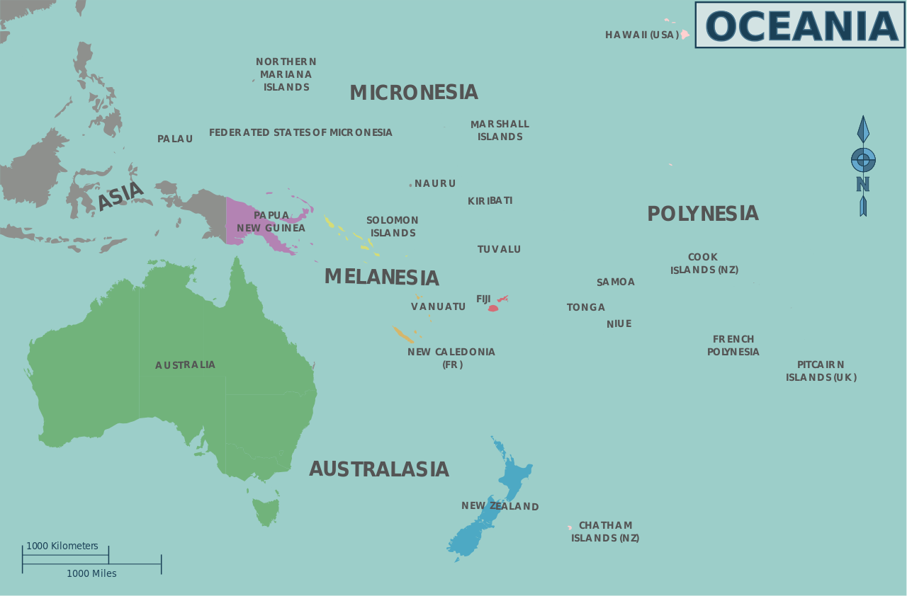
Map of Oceania's regions for use on Wikivoyage, multilingual SVG file |
| Date | |
| Source | Own work based on the blank map of Oceania by Carol Spears and the map of Oceania's regions |
| Author | Cacahuate, translations by Joelf and Globe-trotter |
| Other versions |
PNG files: |
| Other information |
.png)
.png)

|
This file has been superseded by Oceania regions map.svg. It is recommended to use the other file. Please note that deleting superseded images requires consent.
|

|
Licensing edit
This file is licensed under the Creative Commons Attribution-Share Alike 2.5 Generic license.
- You are free:
- to share – to copy, distribute and transmit the work
- to remix – to adapt the work
- Under the following conditions:
- attribution – You must give appropriate credit, provide a link to the license, and indicate if changes were made. You may do so in any reasonable manner, but not in any way that suggests the licensor endorses you or your use.
- share alike – If you remix, transform, or build upon the material, you must distribute your contributions under the same or compatible license as the original.
Original upload log edit
| This file was imported from Wikivoyage WTS. |
The original description page was here. All following user names refer to wts.wikivoyage-old.
- 2010-01-17 20:00 (WT-shared) Cacahuate[dead link] 738×527 (247742 bytes) == Summary == {{Imagecredit |credit=[[User:Cacahuate|Cacahuate]], [[:commons:User:CarolSpears|Carol Spears]] |captureDate=August 31, 2008 |l (Import from wikitravel.org/shared)
- 2010-12-12 23:29 (WT-shared) Joelf[dead link] 804×529 (221457 bytes) +fr (Import from wikitravel.org/shared)
- 2012-09-19 19:51 Globe-trotter[dead link] 804×529 (251295 bytes) +nl
File history
Click on a date/time to view the file as it appeared at that time.
| Date/Time | Thumbnail | Dimensions | User | Comment | |
|---|---|---|---|---|---|
| current | 14:53, 28 November 2012 | | 804 × 529 (245 KB) | OgreBot (talk | contribs) | (BOT): Reverting to most recent version before archival |
| 14:53, 28 November 2012 |  | 804 × 529 (216 KB) | OgreBot (talk | contribs) | (BOT): Uploading old version of file from wts.wikivoyage-old; originally uploaded on 2010-12-12 23:29:13 by (WT-shared) Joelf | |
| 14:53, 28 November 2012 |  | 738 × 527 (242 KB) | OgreBot (talk | contribs) | (BOT): Uploading old version of file from wts.wikivoyage-old; originally uploaded on 2010-01-17 20:00:26 by (WT-shared) Cacahuate | |
| 01:04, 18 November 2012 |  | 804 × 529 (245 KB) | MGA73bot2 (talk | contribs) | {{BotMoveToCommons|wts.oldwikivoyage|year={{subst:CURRENTYEAR}}|month={{subst:CURRENTMONTHNAME}}|day={{subst:CURRENTDAY}}}} == {{int:filedesc}} == {{Information |description=Map of Oceania's regions. '''PNG versions:''' *[[:wts::Image:Map of Oceania.pn... |
You cannot overwrite this file.
File usage on Commons
There are no pages that use this file.
File usage on other wikis
The following other wikis use this file:
- Usage on es.wikipedia.org
- Usage on ie.wikipedia.org