File:Map of Pacific Oceania member nations.svg

Size of this PNG preview of this SVG file: 749 × 479 pixels. Other resolutions: 320 × 205 pixels | 640 × 409 pixels | 1,024 × 655 pixels | 1,280 × 819 pixels | 2,560 × 1,637 pixels.
Original file (SVG file, nominally 749 × 479 pixels, file size: 240 KB)
Captions
Captions
Add a one-line explanation of what this file represents
Summary edit
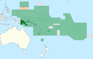
| Description | Map showing member countries of the Oceania Tennis Federation which are represented in the Pacific Oceania Davis and Fed Cup teams. Former members are in orange. |
| Date | (UTC) |
| Source |
This file was derived from: Oceania ISO 3166-1.svg: |
| Author |
|
| This is a retouched picture, which means that it has been digitally altered from its original version. The original can be viewed here: Oceania ISO 3166-1.svg:
|
Licensing edit
This file is licensed under the Creative Commons Attribution-Share Alike 3.0 Unported license.
Attribution: Tintazul
- You are free:
- to share – to copy, distribute and transmit the work
- to remix – to adapt the work
- Under the following conditions:
- attribution – You must give appropriate credit, provide a link to the license, and indicate if changes were made. You may do so in any reasonable manner, but not in any way that suggests the licensor endorses you or your use.
- share alike – If you remix, transform, or build upon the material, you must distribute your contributions under the same or compatible license as the original.
Original upload log edit
This image is a derivative work of the following images:
- File:Oceania ISO 3166-1.svg licensed with azul/licensing template, Cc-by-sa-3.0
- 2015-11-07T17:45:56Z BurritoBazooka 780x500 (149092 Bytes) getting rid of transparent border around map
- 2014-03-25T16:50:17Z Knyaz-1988 800x520 (148086 Bytes) New version
- 2014-03-25T16:49:43Z Knyaz-1988 800x520 (165926 Bytes) Reverted to version as of 04:23, 21 December 2007
- 2007-12-21T04:24:39Z ButterStick 800x520 (165926 Bytes)
- 2007-12-21T04:23:31Z ButterStick 800x520 (165926 Bytes)
- 2007-12-21T04:21:45Z ButterStick 800x520 (165924 Bytes) Code optimization
- 2006-05-30T13:35:26Z Tintazul 800x520 (243617 Bytes) {{Tintazul| |Description=Map of Oceania, with ISO 3166-1 [[:pt:ISO 3166-1|pt]] · [[:en:ISO 3166-1|en]] country and territory code. SVG format. Map legend in Portuguese and English, with name of sovereign state given in pare
Uploaded with derivativeFX
File history
Click on a date/time to view the file as it appeared at that time.
| Date/Time | Thumbnail | Dimensions | User | Comment | |
|---|---|---|---|---|---|
| current | 14:08, 17 September 2021 | | 749 × 479 (240 KB) | Hariboneagle927 (talk | contribs) | adjust |
| 14:06, 17 September 2021 |  | 744 × 415 (240 KB) | Hariboneagle927 (talk | contribs) | == {{int:filedesc}} == {{Information |Description=Map showing member countries of the Oceania Tennis Federation which are represented in the Pacific Oceania Davis and Fed Cup teams. Former members are in orange. |Source={{Derived from|Oceania ISO 3166-1.svg|display=50}} |Date=2021-09-17 14:04 (UTC) |Author=* File:Oceania ISO 3166-1.svg: '''PLEASE COMPLETE AUTHOR INFORMATION''' * derivative work: [[User:{{subst:REVISIONUSER}}|{{subst:REVISIONUSER}}]] |Permissio... |
You cannot overwrite this file.
File usage on Commons
There are no pages that use this file.
File usage on other wikis
The following other wikis use this file:
- Usage on en.wikipedia.org
- Usage on es.wikipedia.org