File:Map of Pr. George, Surry, Sussex, and Southampton counties LOC 2005625082.jpg

Size of this preview: 487 × 599 pixels. Other resolutions: 195 × 240 pixels | 390 × 480 pixels | 624 × 768 pixels | 832 × 1,024 pixels | 1,665 × 2,048 pixels | 4,807 × 5,914 pixels.
Original file (4,807 × 5,914 pixels, file size: 3.95 MB, MIME type: image/jpeg)
Captions
Captions
Add a one-line explanation of what this file represents
Summary edit
| Description |
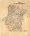
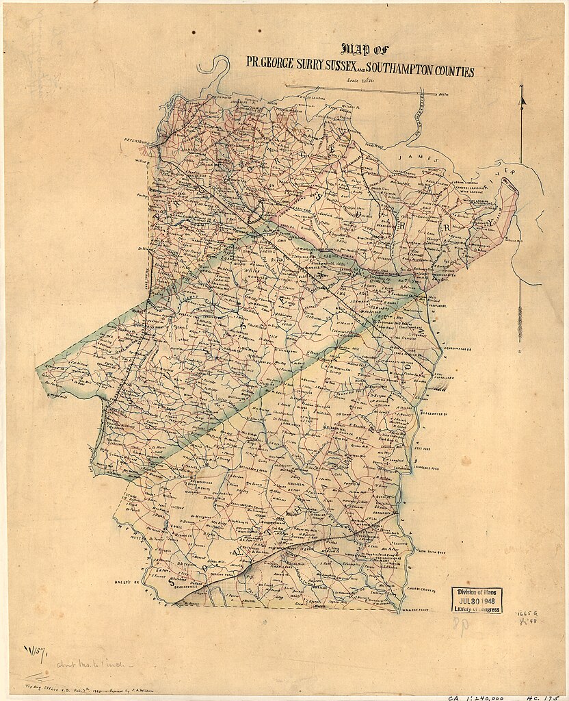
English: Shows names of some residents. Pen-and-ink, watercolor, and pencil on tracing paper, mounted on cloth. LC Civil War maps (2nd ed.), H175 LC Land ownership maps, 1332 In pencil on verso: 98. Available also through the Library of Congress web site as raster image. |
||
| Title | Map of Pr. George, Surry, Sussex, and Southampton counties | ||
| Shelf ID | G3883.P65 1864 .M3 | ||
| Date | |||
| Source | https://www.loc.gov/item/2005625082/ | ||
| Author | Wilson, J. A. | ||
| Permission (Reusing this file) |
|
||
| Other versions |
|
||
| Location | Sussex County · Prince George County · Surry County · Virginia · United States · Southampton County | ||
| Part of | Civil War Maps · County Landownership Maps · Cultural Landscapes · Hotchkiss Map Collection · Military Battles And Campaigns · Catalog · American Memory · Geography And Map Division | ||
| Subject | Sussex County · Maps, Manuscript · Sussex County (Va.) · Southampton County (Va.) · Surry County (Va.) · Virginia · Prince George County (Va.) · Surry County · United States · Maps · Prince George County · Southampton County · Landowners |

Licensing edit
|
This is a faithful photographic reproduction of a two-dimensional, public domain work of art. The work of art itself is in the public domain for the following reason:
The official position taken by the Wikimedia Foundation is that "faithful reproductions of two-dimensional public domain works of art are public domain".
This photographic reproduction is therefore also considered to be in the public domain in the United States. In other jurisdictions, re-use of this content may be restricted; see Reuse of PD-Art photographs for details. | ||||
File history
Click on a date/time to view the file as it appeared at that time.
| Date/Time | Thumbnail | Dimensions | User | Comment | |
|---|---|---|---|---|---|
| current | 06:00, 4 June 2018 | | 4,807 × 5,914 (3.95 MB) | Fæ (talk | contribs) | LOC Maps https://www.loc.gov/item/2005625082/ #4300 |
You cannot overwrite this file.
File usage on Commons
The following page uses this file: