File:Map of Rhode Island NA.png
Size of this preview: 776 × 600 pixels. Other resolutions: 311 × 240 pixels | 621 × 480 pixels | 994 × 768 pixels | 1,280 × 989 pixels | 2,122 × 1,640 pixels.
Original file (2,122 × 1,640 pixels, file size: 822 KB, MIME type: image/png)
Captions
Captions
Add a one-line explanation of what this file represents
Summary
edit
| Description |
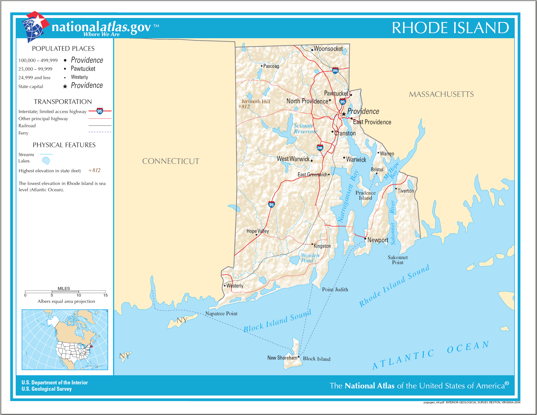
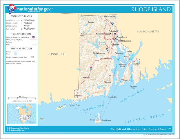
English: National Atlas map of Rhode Island. |
| Date | |
| Source | National Atlas |
| Author |
Licensing
edit
This map was obtained from an edition of the National Atlas of the United States. Like almost all works of the U.S. federal government, works from the National Atlas are in the public domain in the United States.
Online access: NationalAtlas.gov | 1970 print edition: Library of Congress, Perry-Castañeda Library
|
File history
Click on a date/time to view the file as it appeared at that time.
| Date/Time | Thumbnail | Dimensions | User | Comment | |
|---|---|---|---|---|---|
| current | 14:16, 17 April 2015 | | 2,122 × 1,640 (822 KB) | RokerHRO (talk | contribs) | optipng -o7 -i0 → 18.34% decrease |
| 08:22, 15 August 2006 |  | 2,122 × 1,640 (1,007 KB) | Huebi~commonswiki (talk | contribs) | {{Information| |Description=Map of Rhode Island |Source=[http://www.nationalatlas.gov National Atlas] }} Category:Maps of the United States Category:Maps of Rhode Island {{PD-USGov-Atlas}} |
You cannot overwrite this file.
File usage on Commons
More than 100 pages use this file. The following list shows the first 100 pages that use this file only. A full list is available.
- Category:1857 in Rhode Island
- Category:1860 in Rhode Island
- Category:1875 in Rhode Island
- Category:1896 in Rhode Island
- Category:1901 in Rhode Island
- Category:1939 in Rhode Island
- Category:1953 in Rhode Island
- Category:1954 in Rhode Island
- Category:1958 in Rhode Island
- Category:1962 in Rhode Island
- Category:1966 in Rhode Island
- Category:1967 in Rhode Island
- Category:1969 in Rhode Island
- Category:1971 in Rhode Island
- Category:1972 in Rhode Island
- Category:1973 in Rhode Island
- Category:1984 in Rhode Island
- Category:1985 in Rhode Island
- Category:1989 in Rhode Island
- Category:1990 in Rhode Island
- Category:1991 in Rhode Island
- Category:1993 in Rhode Island
- Category:2000 in Rhode Island
- Category:2005 in Rhode Island
- Category:2006 in Rhode Island
- Category:2007 in Rhode Island
- Category:2008 in Rhode Island
- Category:2009 in Rhode Island
- Category:2010 in Rhode Island
- Category:2011 in Rhode Island
- Category:2012 in Rhode Island
- Category:2013 in Rhode Island
- Category:Airports in Rhode Island
- Category:Architecture of Rhode Island
- Category:Art of Rhode Island
- Category:Bays of Rhode Island
- Category:Beaches of Rhode Island
- Category:Botanical gardens in Rhode Island
- Category:Bridges in Rhode Island
- Category:Cemeteries in Rhode Island
- Category:Cities in Rhode Island
- Category:Education in Rhode Island
- Category:Energy in Rhode Island
- Category:Events in Rhode Island
- Category:Flora of Rhode Island
- Category:Geology of Rhode Island
- Category:Islands of Rhode Island
- Category:Lakes of Rhode Island
- Category:Lighthouses in Rhode Island
- Category:Maps of Rhode Island
- Category:Metropolitan areas of Rhode Island
- Category:Protected areas of Rhode Island
- Category:Religion in Rhode Island
- Category:Rhode Island
- Category:Rhode Island by decade
- Category:Rhode Island by year
- Category:Rhode Island in the 1700s
- Category:Rhode Island in the 1720s
- Category:Rhode Island in the 1730s
- Category:Rhode Island in the 1740s
- Category:Rhode Island in the 1750s
- Category:Rhode Island in the 1770s
- Category:Rhode Island in the 1780s
- Category:Rhode Island in the 1790s
- Category:Rhode Island in the 17th century
- Category:Rhode Island in the 1800s
- Category:Rhode Island in the 1810s
- Category:Rhode Island in the 1820s
- Category:Rhode Island in the 1830s
- Category:Rhode Island in the 1840s
- Category:Rhode Island in the 1850s
- Category:Rhode Island in the 1860s
- Category:Rhode Island in the 1870s
- Category:Rhode Island in the 1880s
- Category:Rhode Island in the 1890s
- Category:Rhode Island in the 18th century
- Category:Rhode Island in the 1900s
- Category:Rhode Island in the 1910s
- Category:Rhode Island in the 1920s
- Category:Rhode Island in the 1930s
- Category:Rhode Island in the 1940s
- Category:Rhode Island in the 1950s
- Category:Rhode Island in the 1960s
- Category:Rhode Island in the 1970s
- Category:Rhode Island in the 1980s
- Category:Rhode Island in the 1990s
- Category:Rhode Island in the 19th century
- Category:Rhode Island in the 2000s
- Category:Rhode Island in the 2010s
- Category:Rhode Island in the 20th century
- Category:Rhode Island in the 21st century
- Category:Rivers of Rhode Island
- Category:Roads in Rhode Island
- Category:Schools in Rhode Island
- Category:Sports venues in Rhode Island
- Category:Towers in Rhode Island
- Category:Towns in Rhode Island
- Category:Transport in Rhode Island
- Category:Unincorporated communities in Rhode Island
- Category:Visitor attractions in Rhode Island
View more links to this file.
File usage on other wikis
The following other wikis use this file:
- Usage on als.wikipedia.org
- Usage on ang.wikipedia.org
- Usage on be.wikipedia.org
- Usage on ca.wikipedia.org
- Usage on de.wikipedia.org
- Usage on en.wikipedia.org
- Usage on fi.wikipedia.org
- Usage on ga.wikipedia.org
- Usage on gl.wikipedia.org
- Usage on hu.wikipedia.org
- Usage on hy.wikipedia.org
- Usage on ja.wikipedia.org
- Usage on ko.wikipedia.org
- Usage on lt.wikipedia.org
- Usage on mhr.wikipedia.org
- Usage on mr.wikipedia.org
- Usage on os.wikipedia.org
- Usage on sw.wikipedia.org
- Usage on tg.wikipedia.org
- Usage on tt.wikipedia.org
- Usage on www.wikidata.org
- Usage on zea.wikipedia.org