File:Map of South America (fr).png

Size of this preview: 492 × 599 pixels. Other resolutions: 197 × 240 pixels | 394 × 480 pixels | 631 × 768 pixels | 1,131 × 1,377 pixels.
Original file (1,131 × 1,377 pixels, file size: 329 KB, MIME type: image/png)
Captions
Captions
Add a one-line explanation of what this file represents
Summary edit
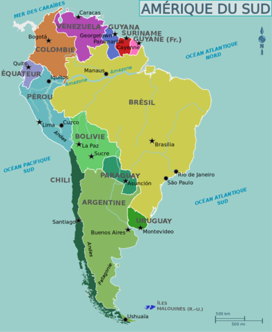
| Description | Map of South America for use on Wikivoyage, French version |
| Date | |
| Source | Own work based on an earlier map by canislupusarctos |
| Author | Cacahuate, French translation by Joelf |
| Other versions |
[]
|


.png)
.png)
.png)

.png)
.png)

.png&action=edit§ion=1)
Licensing edit
.png&action=edit§ion=2)
This file is licensed under the Creative Commons Attribution-Share Alike 3.0 Unported license.
- You are free:
- to share – to copy, distribute and transmit the work
- to remix – to adapt the work
- Under the following conditions:
- attribution – You must give appropriate credit, provide a link to the license, and indicate if changes were made. You may do so in any reasonable manner, but not in any way that suggests the licensor endorses you or your use.
- share alike – If you remix, transform, or build upon the material, you must distribute your contributions under the same or compatible license as the original.
Original upload log edit
.png&action=edit§ion=3)
| This file was imported from Wikivoyage WTS. |
The original description page was here. All following user names refer to wts.wikivoyage-old.
.png)
- 2011-08-06 05:39 (WT-shared) Joelf[dead link] 1131×1377 (352921 bytes) {{Imagecredit|credit=[[User:Cacahuate|Cacahuate]], [[User:Mark|Mark]] (WT logo), [[:commons:User:canislupusarctos|canislupusarctos]] (svg ba (Import from wikitravel.org/shared)
- 2012-09-09 05:04 Shaund[dead link] 1131×1376 (353651 bytes) rmv logo
- 2012-09-09 05:06 Shaund[dead link] 1131×1377 (352921 bytes) Reverted to version as of 05:39, 6 August 2011
- 2012-09-09 05:12 Shaund[dead link] 1131×1377 (337218 bytes) rmv logo from most recent map (previous reversion was an older map)
File history
Click on a date/time to view the file as it appeared at that time.
| Date/Time | Thumbnail | Dimensions | User | Comment | |
|---|---|---|---|---|---|
| current | 18:11, 15 December 2012 | | 1,131 × 1,377 (329 KB) | OgreBot (talk | contribs) | (BOT): Reverting to most recent version before archival |
| 18:11, 15 December 2012 |  | 1,131 × 1,376 (345 KB) | OgreBot (talk | contribs) | (BOT): Uploading old version of file from wts.wikivoyage; originally uploaded on 2012-09-09 05:04:44 by Shaund | |
| 18:11, 15 December 2012 |  | 1,131 × 1,377 (345 KB) | OgreBot (talk | contribs) | (BOT): Uploading old version of file from wts.wikivoyage; originally uploaded on 2011-08-06 05:39:29 by (WT-shared) Joelf | |
| 01:05, 18 November 2012 |  | 1,131 × 1,377 (329 KB) | MGA73bot2 (talk | contribs) | {{BotMoveToCommons|wts.oldwikivoyage|year={{subst:CURRENTYEAR}}|month={{subst:CURRENTMONTHNAME}}|day={{subst:CURRENTDAY}}}} == {{int:filedesc}} == {{Information |description=Carte de l'Amérique du Sud. Version française, South America * Map of: South... |
You cannot overwrite this file.
File usage on Commons
The following 10 pages use this file:
- File:Map of South America(pt).png
- File:Map of South America.png
- File:Map of South America (eo).png
- File:Map of South America (fr).png
- File:Map of South America (he).png
- File:Map of South America (nl).png
- File:Map of South America (zh-hans).png
- File:Map of South America ka.png
- File:South America Color-coded Regions.png
- Template:Other versions/Map of South America
.png)
File usage on other wikis
The following other wikis use this file:
- Usage on fr.wikivoyage.org
.png&oldid=792534848)