File:Map of South America (nl).png
Size of this preview: 493 × 600 pixels. Other resolutions: 197 × 240 pixels | 394 × 480 pixels | 631 × 768 pixels | 1,131 × 1,376 pixels.
Original file (1,131 × 1,376 pixels, file size: 309 KB, MIME type: image/png)
Captions
Captions
Add a one-line explanation of what this file represents
Summary edit
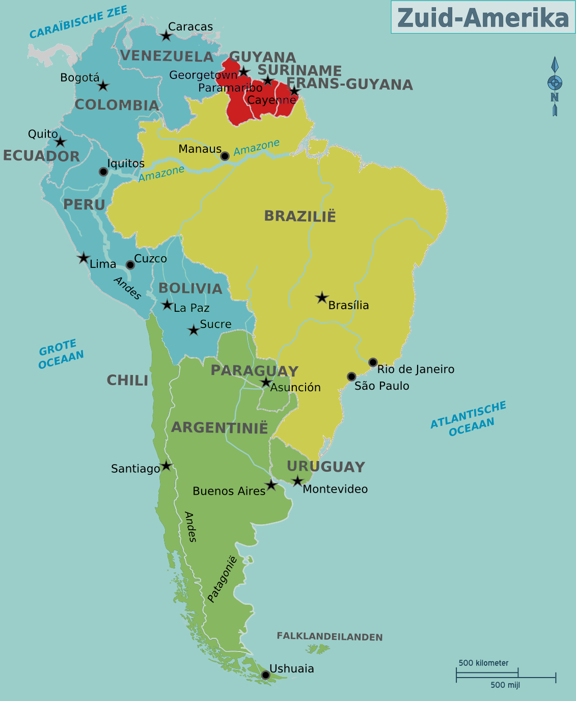
| Description | Map of South America for use on Wikivoyage, Dutch version |
| Date | |
| Source | Own work based on an earlier map by canislupusarctos |
| Author | Cacahuate, amendments by Joelf, Dutch translation by Globe-trotter |
| Other versions |
[]
|


.png)
.png)
.png)

.png)
.png)

.png&action=edit§ion=1)
Licensing edit
.png&action=edit§ion=2)
This file is licensed under the Creative Commons Attribution-Share Alike 3.0 Unported license.
- You are free:
- to share – to copy, distribute and transmit the work
- to remix – to adapt the work
- Under the following conditions:
- attribution – You must give appropriate credit, provide a link to the license, and indicate if changes were made. You may do so in any reasonable manner, but not in any way that suggests the licensor endorses you or your use.
- share alike – If you remix, transform, or build upon the material, you must distribute your contributions under the same or compatible license as the original.
Original upload log edit
.png&action=edit§ion=3)
| This file was imported from Wikivoyage WTS. |
The original description page was here. All following user names refer to wts.wikivoyage-old.
.png)
- 2012-09-19 19:35 Globe-trotter[dead link] 1131×1376 (339290 bytes) {{Imagecredit|credit=[[User:(WT-shared) Cacahuate|(WT-shared) Cacahuate]], [[:commons:User:canislupusarctos|canislupusarctos]] (svg base)|captureDate=|location=South America|source=[[:Image:Map of South America.svg]]|caption=Map of South America|descri...
File history
Click on a date/time to view the file as it appeared at that time.
| Date/Time | Thumbnail | Dimensions | User | Comment | |
|---|---|---|---|---|---|
| current | 15:23, 14 August 2013 | | 1,131 × 1,376 (309 KB) | Ischa1 (talk | contribs) | Nieuwe versie geüpload, aansluitend op de regio's van Zuid-Amerika zoals ze op de Nederlandse Wikivoyage staan... |
| 01:06, 18 November 2012 |  | 1,131 × 1,376 (331 KB) | MGA73bot2 (talk | contribs) | {{BotMoveToCommons|wts.oldwikivoyage|year={{subst:CURRENTYEAR}}|month={{subst:CURRENTMONTHNAME}}|day={{subst:CURRENTDAY}}}} == {{int:filedesc}} == {{Information |description=Map of South America. Dutch version, South America * Map of: South America¤ |... |
You cannot overwrite this file.
File usage on Commons
The following 10 pages use this file:
- File:Map of South America(pt).png
- File:Map of South America.png
- File:Map of South America (eo).png
- File:Map of South America (fr).png
- File:Map of South America (he).png
- File:Map of South America (nl).png
- File:Map of South America (zh-hans).png
- File:Map of South America ka.png
- File:South America Color-coded Regions.png
- Template:Other versions/Map of South America
.png)
.png&oldid=792534919)