File:Map of Trans-African Highways.PNG
Size of this preview: 600 × 600 pixels. Other resolutions: 240 × 240 pixels | 480 × 480 pixels | 832 × 832 pixels.
Original file (832 × 832 pixels, file size: 211 KB, MIME type: image/png)
Captions
Captions
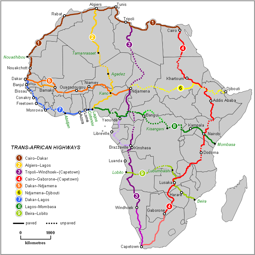
Map of Trans-African Highways 2022, per Michelin Afrique & Google Earth

|
This road map image could be re-created using vector graphics as an SVG file. This has several advantages; see Commons:Media for cleanup for more information. If an SVG form of this image is available, please upload it and afterwards replace this template with
{{vector version available|new image name}}.
It is recommended to name the SVG file “Map of Trans-African Highways.svg”—then the template Vector version available (or Vva) does not need the new image name parameter. |
Summary edit
| Description |
English: Map of Trans-African Highways based on data 2000 to 2003 |
| Date | |
| Source | Word doc drawing based in Wikipedia blank Africa map |
| Author | Rex Parry |
| Other versions |
|
Licensing edit
I, Rexparry sydney, the copyright holder of this work, hereby publishes it under the following licenses:

|
Permission is granted to copy, distribute and/or modify this document under the terms of the GNU Free Documentation License, Version 1.2 or any later version published by the Free Software Foundation; with no Invariant Sections, no Front-Cover Texts, and no Back-Cover Texts. A copy of the license is included in the section entitled GNU Free Documentation License. |
| This file is licensed under the Creative Commons Attribution-Share Alike 3.0 Unported license. | ||
| Attribution: I, Rexparry sydney | ||
| ||
| This licensing tag was added to this file as part of the GFDL licensing update. |
This file is licensed under the Creative Commons Attribution-Share Alike 2.5 Generic, 2.0 Generic and 1.0 Generic license.
Attribution: I, Rexparry sydney
- You are free:
- to share – to copy, distribute and transmit the work
- to remix – to adapt the work
- Under the following conditions:
- attribution – You must give appropriate credit, provide a link to the license, and indicate if changes were made. You may do so in any reasonable manner, but not in any way that suggests the licensor endorses you or your use.
- share alike – If you remix, transform, or build upon the material, you must distribute your contributions under the same or compatible license as the original.
You may select the license of your choice.
| Annotations | This image is annotated: View the annotations at Commons |
File history
Click on a date/time to view the file as it appeared at that time.
| Date/Time | Thumbnail | Dimensions | User | Comment | |
|---|---|---|---|---|---|
| current | 11:28, 19 June 2023 | | 832 × 832 (211 KB) | Abdelrhman 1990 (talk | contribs) | Map correction |
| 05:56, 6 February 2022 |  | 832 × 832 (155 KB) | SounderBruce (talk | contribs) | Reverted to version as of 20:18, 8 November 2020 (UTC): Improper upscaling | |
| 00:45, 19 January 2022 |  | 1,922 × 1,918 (1,016 KB) | Arrecife (talk | contribs) | 2022 update per Michelin Afrique & Google Earth | |
| 16:24, 14 January 2022 |  | 615 × 614 (185 KB) | Arrecife (talk | contribs) | Reverted to version as of 05:53, 6 December 2019 (UTC) smaller size, but up to date | |
| 20:18, 8 November 2020 |  | 832 × 832 (155 KB) | Leviavery (talk | contribs) | Reverted to version as of 09:25, 23 August 2019 (UTC) Much higher quality image | |
| 05:53, 6 December 2019 |  | 615 × 614 (185 KB) | Arrecife (talk | contribs) | Updating of all roads, from Michelin Africa plus Google Earth | |
| 09:25, 23 August 2019 |  | 832 × 832 (155 KB) | NordNordWest (talk | contribs) | adding South Sudan | |
| 00:02, 9 October 2014 |  | 832 × 832 (202 KB) | Bobrayner (talk | contribs) | Slight corrections/updates to map, ie. Nouakchott-Nouadhibou road was completely surfaced a few years ago Morocco-Algeria border is closed; &c. | |
| 07:12, 18 July 2007 |  | 832 × 832 (175 KB) | Rexparry sydney~commonswiki (talk | contribs) | {{Information |Description=Map of Trans-African Highways based on data 2000 to 2003 |Source=Word doc drawing based in Wikipedia blank Africa map |Date=17 July 2007 |Author=Rex Parry |Permission=Yes |other_versions= }} |
You cannot overwrite this file.
File usage on Commons
The following 24 pages use this file:
- Map
- Maps of Africa
- Top 200 transport map images that should use vector graphics
- User:Chumwa/OgreBot/Potential transport maps/2019 August 21-31
- User:Chumwa/OgreBot/Potential transport maps/2019 December 1-10
- User:Chumwa/OgreBot/Transport Maps/2019 August 21-31
- User:Chumwa/OgreBot/Transport Maps/2019 December 1-10
- User:Chumwa/OgreBot/Transport Maps/2020 November 1-10
- User:Chumwa/OgreBot/Transport Maps/2022 February 1-9
- User:Chumwa/OgreBot/Transport Maps/2022 January 11-20
- User:Chumwa/OgreBot/Transport Maps/2023 June 11-20
- User:Chumwa/OgreBot/Travel and communication maps/2019 August 21-31
- User:Chumwa/OgreBot/Travel and communication maps/2019 December 1-10
- User:Chumwa/OgreBot/Travel and communication maps/2020 November 1-10
- User:Chumwa/OgreBot/Travel and communication maps/2022 February 1-9
- User:Chumwa/OgreBot/Travel and communication maps/2022 January 11-20
- User:Chumwa/OgreBot/Travel and communication maps/2023 June 11-20
- User:Magog the Ogre/Multilingual legend/2020 November 1-10
- User:Magog the Ogre/Multilingual legend/2022 February 1-9
- User:Magog the Ogre/Multilingual legend/2022 January 11-20
- User:Magog the Ogre/Multilingual legend/2023 June 11-20
- Commons:Files used on the AARoads Wiki/41
- Commons:Files used on the OpenStreetMap Wiki/17
- Category:Trans-African Highway network
File usage on other wikis
The following other wikis use this file:
- Usage on af.wikipedia.org
- Usage on ar.wikipedia.org
- Usage on arz.wikipedia.org
- Usage on bs.wikipedia.org
- Usage on de.wikipedia.org
- Usage on en.wikipedia.org
- Usage on es.wikipedia.org
- Usage on fa.wikipedia.org
- Usage on fr.wikipedia.org
- Usage on he.wikipedia.org
- Usage on hu.wikipedia.org
- Usage on hy.wikipedia.org
- Usage on id.wikipedia.org
- Usage on it.wikipedia.org
- Usage on it.wikivoyage.org
- Usage on ja.wikipedia.org
- Usage on kk.wikipedia.org
- Usage on nl.wikipedia.org
- Usage on no.wikipedia.org
- Usage on pl.wikipedia.org
- Usage on pt.wikipedia.org
View more global usage of this file.