File:Map of Williamsburg Virginia 1702 Franz Michel.jpg
No higher resolution available.
Map_of_Williamsburg_Virginia_1702_Franz_Michel.jpg (432 × 272 pixels, file size: 46 KB, MIME type: image/jpeg)
Captions
Captions
Add a one-line explanation of what this file represents
Summary edit
| Description |
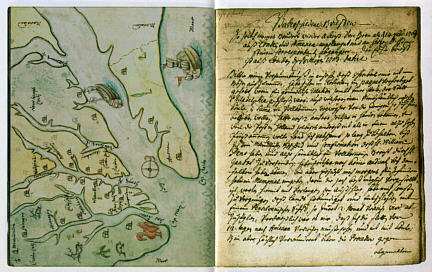
English: One of the earliest maps of Williamsburg (Middle Plantation), drawn by Franz Michel, a native of Switzerland who traveled to America. Michel's fanciful map shows ships, deer and a turkey, as well as Williamsburg "between the Jems and Jorgk Rivier, six miles from the Jems and ten from Jorgtown." On the page facing the map is a letter from Michel to his brother Hans. |
| Date | |
| Source | http://www.patc.us/history/native/michel2.html |
| Author | Franz Michel |
Licensing edit
|
This work is in the public domain in its country of origin and other countries and areas where the copyright term is the author's life plus 100 years or fewer. | |
| This file has been identified as being free of known restrictions under copyright law, including all related and neighboring rights. | |
File history
Click on a date/time to view the file as it appeared at that time.
| Date/Time | Thumbnail | Dimensions | User | Comment | |
|---|---|---|---|---|---|
| current | 12:39, 14 June 2010 | | 432 × 272 (46 KB) | MarmadukePercy (talk | contribs) | {{Information |Description={{en|1=One of the earliest maps of Williamsburg (Middle Plantation), drawn by Franz Michel, a native of Switzerland who traveled to America. Michel's fanciful map shows ships, deer and a turkey, as well as Williamsburg "between |
You cannot overwrite this file.
File usage on Commons
There are no pages that use this file.
File usage on other wikis
The following other wikis use this file:
- Usage on en.wikipedia.org
- Usage on ja.wikipedia.org