File:Map of York County, Pennsylvania.png
Size of this preview: 800 × 550 pixels. Other resolutions: 320 × 220 pixels | 640 × 440 pixels | 1,024 × 704 pixels | 1,280 × 880 pixels | 2,196 × 1,509 pixels.
Original file (2,196 × 1,509 pixels, file size: 118 KB, MIME type: image/png)
Captions
Captions
Add a one-line explanation of what this file represents
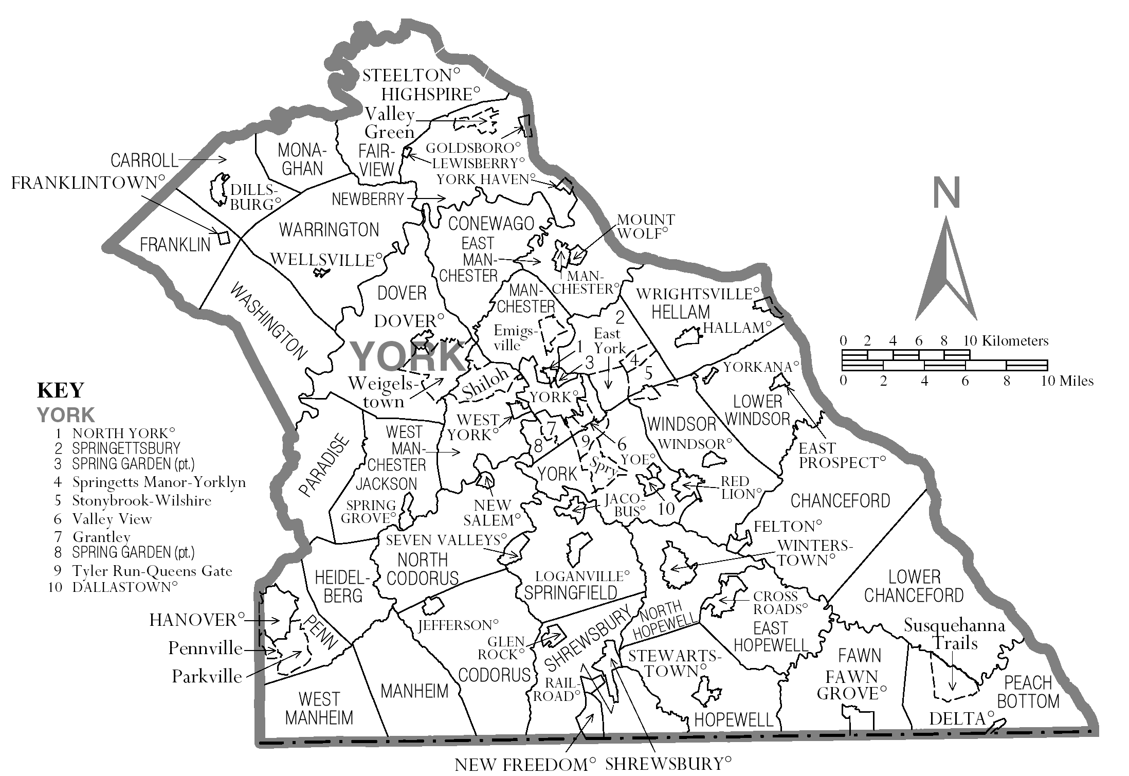
| Description | Map of York County. | |||
| Date | ||||
| Source | Source image taken from the United States Census Bureau's website pa_cosub.pdf. Image was modified by Ram-Man. | |||
| Author | (c)2006 Derek Ramsey (Ram-Man) (from U.S. Census Bureau source) | |||
| Permission (Reusing this file) |
A United States Census Bureau / Government work is in the public domain, however, my modifications are licensed as follows: You may NOT use this image on your own web site or anywhere else unless you release this image and any derivative works (e.g. your web site) by following the terms of one of the following licenses. Any other use will be considered a breach of copyright and I reserve the right of legal action. If you have not read the terms of these licenses or do not understand them, then do not use this image. I, the copyright holder of this work, hereby publish it under the following licenses:
This file is licensed under the Creative Commons Attribution-Share Alike 2.5 Generic, 2.0 Generic and 1.0 Generic license.
You may select the license of your choice. |
|||
| Other versions | Image:Map of York County, Pennsylvania No Text.png - Version without text |

File history
Click on a date/time to view the file as it appeared at that time.
| Date/Time | Thumbnail | Dimensions | User | Comment | |
|---|---|---|---|---|---|
| current | 19:58, 16 July 2015 | | 2,196 × 1,509 (118 KB) | Cmdrjameson (talk | contribs) | Compressed with pngout. Reduced by 180kB (60% decrease). |
| 00:58, 11 October 2006 |  | 2,196 × 1,509 (298 KB) | Ram-Man (talk | contribs) | {{Information| |Description=Map of York County. |Source=Source image taken from the United States Census Bureau's website [http://www2.census.gov/geo/maps/general_ref/cousub_outline/cen2k_pgsz/pa_cosub.pdf pa_cosub.pdf]. |
You cannot overwrite this file.
File usage on Commons
There are no pages that use this file.