File:Map of Zanzibar Archipelago ru.svg

Size of this PNG preview of this SVG file: 474 × 599 pixels. Other resolutions: 190 × 240 pixels | 380 × 480 pixels | 607 × 768 pixels | 810 × 1,024 pixels | 1,620 × 2,048 pixels | 628 × 794 pixels.
Original file (SVG file, nominally 628 × 794 pixels, file size: 832 KB)
Captions
Captions
Add a one-line explanation of what this file represents
Summary edit
| Description |
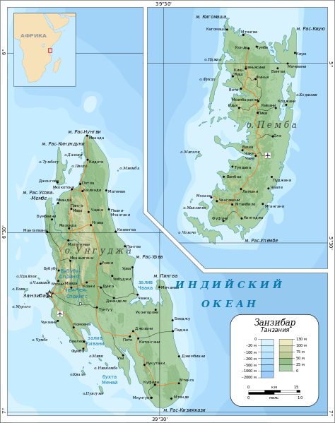
English: Topographic map of Zanzibar Archipelago, Tanzania.
Русский: Топографическая карта Занзибарского архипелага (Танзания).
Suomi: Sansibarin saariston topografinen kartta. |
| Date | (UTC) |
| Source | |
| Author |
|
| Other versions |
[]
|


| This is a retouched picture, which means that it has been digitally altered from its original version. Modifications: перевод. The original can be viewed here: Map of Zanzibar Archipelago-en.svg:
|

|
This SVG file contains embedded text that can be translated into your language, using any capable SVG editor, text editor or the SVG Translate tool. For more information see: About translating SVG files. |
Licensing edit
I, the copyright holder of this work, hereby publish it under the following licenses:
This file is licensed under the Creative Commons Attribution-Share Alike 3.0 Unported, 2.5 Generic, 2.0 Generic and 1.0 Generic license.
- You are free:
- to share – to copy, distribute and transmit the work
- to remix – to adapt the work
- Under the following conditions:
- attribution – You must give appropriate credit, provide a link to the license, and indicate if changes were made. You may do so in any reasonable manner, but not in any way that suggests the licensor endorses you or your use.
- share alike – If you remix, transform, or build upon the material, you must distribute your contributions under the same or compatible license as the original.

|
Permission is granted to copy, distribute and/or modify this document under the terms of the GNU Free Documentation License, Version 1.2 or any later version published by the Free Software Foundation; with no Invariant Sections, no Front-Cover Texts, and no Back-Cover Texts. A copy of the license is included in the section entitled GNU Free Documentation License. |
You may select the license of your choice.
Original upload log edit
This image is a derivative work of the following images:
- File:Map_of_Zanzibar_Archipelago-en.svg licensed with Cc-by-sa-3.0,2.5,2.0,1.0, GFDL
- 2010-09-06T08:25:20Z Mysid 628x794 (836431 Bytes) returning to old colors
- 2010-07-22T13:07:17Z Mysid 628x794 (834861 Bytes) +valid
- 2010-07-22T13:00:59Z Mysid 628x794 (834879 Bytes) location map
- 2010-07-21T11:33:35Z Mysid 628x794 (827521 Bytes) final touch...
- 2010-07-21T06:32:53Z Mysid 628x794 (827854 Bytes) oops
- 2010-07-21T06:29:10Z Mysid 628x794 (827824 Bytes) grid etc
- 2010-07-21T05:45:31Z Mysid 628x794 (822168 Bytes) {{inkscape}} == {{int:filedesc}} == {{Information |Description= {{en|Topographic map of Zanzibar Archipelago, Tanzania.}} {{fi|Sansibarin saariston topografinen kartta.}} |Source=Roads, rivers and place names based on a publi
Uploaded with derivativeFX
File history
Click on a date/time to view the file as it appeared at that time.
| Date/Time | Thumbnail | Dimensions | User | Comment | |
|---|---|---|---|---|---|
| current | 05:38, 18 November 2012 | | 628 × 794 (832 KB) | Tetromino (talk | contribs) | Пнемба → Мнемба; см. ru:Обсуждение участника:Koryakov Yuri#File:Map of Zanzibar Archipelago ru.svg |
| 16:42, 12 September 2010 |  | 628 × 794 (832 KB) | Виктор В (talk | contribs) | ещё исправления названий | |
| 15:05, 12 September 2010 |  | 628 × 794 (832 KB) | Koryakov Yuri (talk | contribs) | исправил несколько опечаток и ъ, добавил дефисы и о. (для островов) | |
| 09:31, 12 September 2010 |  | 628 × 794 (830 KB) | Виктор В (talk | contribs) | м | |
| 09:29, 12 September 2010 |  | 628 × 794 (830 KB) | Виктор В (talk | contribs) | вернул шрифты | |
| 09:09, 12 September 2010 |  | 628 × 794 (830 KB) | Виктор В (talk | contribs) | == {{int:filedesc}} == {{Information |Description={{en|Topographic map of Zanzibar Archipelago, Tanzania.}} {{ru|Топографическая карта Занзибарского архипелага (Танзания).}} {{fi|Sansibarin saariston topo |
You cannot overwrite this file.
File usage on Commons
The following 13 pages use this file:
- File:Map of Zanzibar Archipelago-de.svg
- File:Map of Zanzibar Archipelago-en.svg
- File:Map of Zanzibar Archipelago-fi.svg
- File:Map of Zanzibar Archipelago-mk.svg
- File:Map of Zanzibar Archipelago-no.svg
- File:Map of Zanzibar Archipelago-sv.svg
- File:Map of Zanzibar Archipelago ru.svg
- File:Topographic map of Zanzibar-de.svg
- File:Topographic map of Zanzibar-en.svg
- File:Topographic map of Zanzibar-hu.svg
- File:Topographic map of Zanzibar-mk.svg
- File:Topographic map of Zanzibar-no.svg
- Template:Other versions/Map of Zanzibar Archipelago
File usage on other wikis
The following other wikis use this file:
- Usage on kk.wikipedia.org
- Usage on os.wikipedia.org
- Usage on ru.wikipedia.org