File:Map of a route through south west Pennsylvania from Fort Loudon, Franklin Co. to Fort Pitt, Pittsburgh. LOC gm71000599.jpg

Size of this preview: 266 × 600 pixels. Other resolutions: 106 × 240 pixels | 213 × 480 pixels | 340 × 768 pixels | 454 × 1,024 pixels | 908 × 2,048 pixels | 3,714 × 8,374 pixels.
Original file (3,714 × 8,374 pixels, file size: 3.15 MB, MIME type: image/jpeg)
Captions
Captions
Add a one-line explanation of what this file represents
Summary
edit| Description |
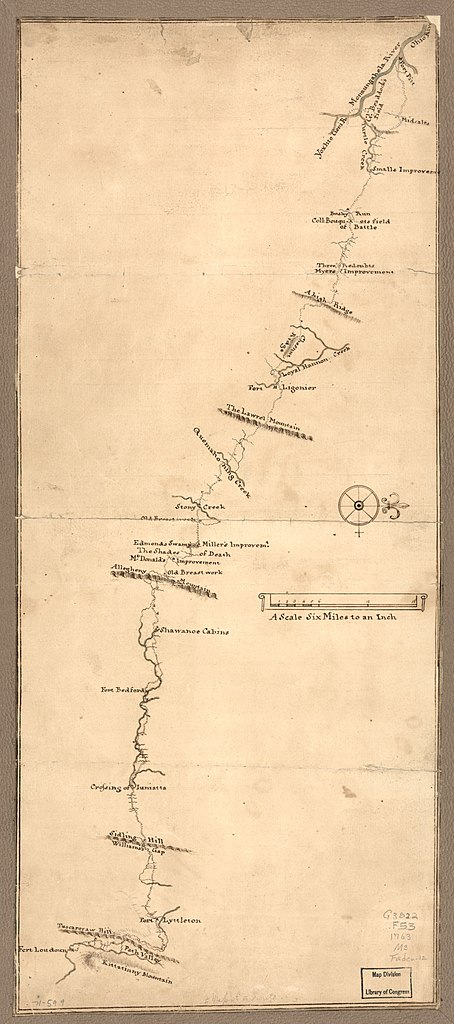
English: Scale 1:380,160; 6 miles to an in. Title from Philip Lee Phillips' A list of maps of America, p. 673. Variant title from William Faden's Catalogue of a curious and valuable collection ... no. 12: A map of the country on the Ohio & Muskingum Rivers. Manuscript, pen-and-ink and watercolor. Oriented with north to the right. Shows location of forts and road improvements. Typed label on verso: Forbes Road from Fort Loudon to Fort Pitt. 1763? LC Maps of North America, 1750-1789, 1304 Available also through the Library of Congress Web site as a raster image. Vault AACR2: 651/2; 650/2 |
||
| Title | Map of a route through south west Pennsylvania from Fort Loudon, Franklin Co. to Fort Pitt, Pittsburgh. | ||
| Shelf ID | G3822.F53 1763 .M3 | ||
| Date | |||
| Source | https://www.loc.gov/item/gm71000599/ | ||
| Author | Unknown author | ||
| Permission (Reusing this file) |
|
||
| Other versions |
|
||
| Location | Pennsylvania · United States · Forbes Road | ||
| Part of | Military Battles And Campaigns · American Memory · Catalog · Geography And Map Division · American Revolution And Its Era: Maps And Charts Of North America And The West Indies, 1750-1789 | ||
| Subject | Maps, Manuscript · Pennsylvania · United States · Early Works To 1800 · Forbes Road (Pa.) · Forbes Road |


Licensing
edit
|
This is a faithful photographic reproduction of a two-dimensional, public domain work of art. The work of art itself is in the public domain for the following reason:
The official position taken by the Wikimedia Foundation is that "faithful reproductions of two-dimensional public domain works of art are public domain".
This photographic reproduction is therefore also considered to be in the public domain in the United States. In other jurisdictions, re-use of this content may be restricted; see Reuse of PD-Art photographs for details. | ||||
| Annotations | This image is annotated: View the annotations at Commons |
File history
Click on a date/time to view the file as it appeared at that time.
| Date/Time | Thumbnail | Dimensions | User | Comment | |
|---|---|---|---|---|---|
| current | 17:14, 12 June 2018 | | 3,714 × 8,374 (3.15 MB) | Fæ (talk | contribs) | LOC Maps https://www.loc.gov/item/gm71000599/ #13100 |
You cannot overwrite this file.
File usage on Commons
The following page uses this file:
File usage on other wikis
The following other wikis use this file:
- Usage on en.wikipedia.org