File:Map of the Gulf of Catarro WDL472.png
Size of this preview: 800 × 581 pixels. Other resolutions: 320 × 233 pixels | 640 × 465 pixels | 1,024 × 744 pixels | 1,280 × 930 pixels | 1,409 × 1,024 pixels.
Original file (1,409 × 1,024 pixels, file size: 2.04 MB, MIME type: image/png)
Captions
Captions
Add a one-line explanation of what this file represents
Summary edit
| Title |
Русский: Карта залива Катарро
Français : Carte du Golfe de Catarro
English: Map of the Gulf of Catarro
中文:卡塔罗湾地图
Português: Mapa do Golfo do Catarro
العربية: خريطة خليج كاتارو
Español: Mapa del Golfo de Catarro |
| Description |
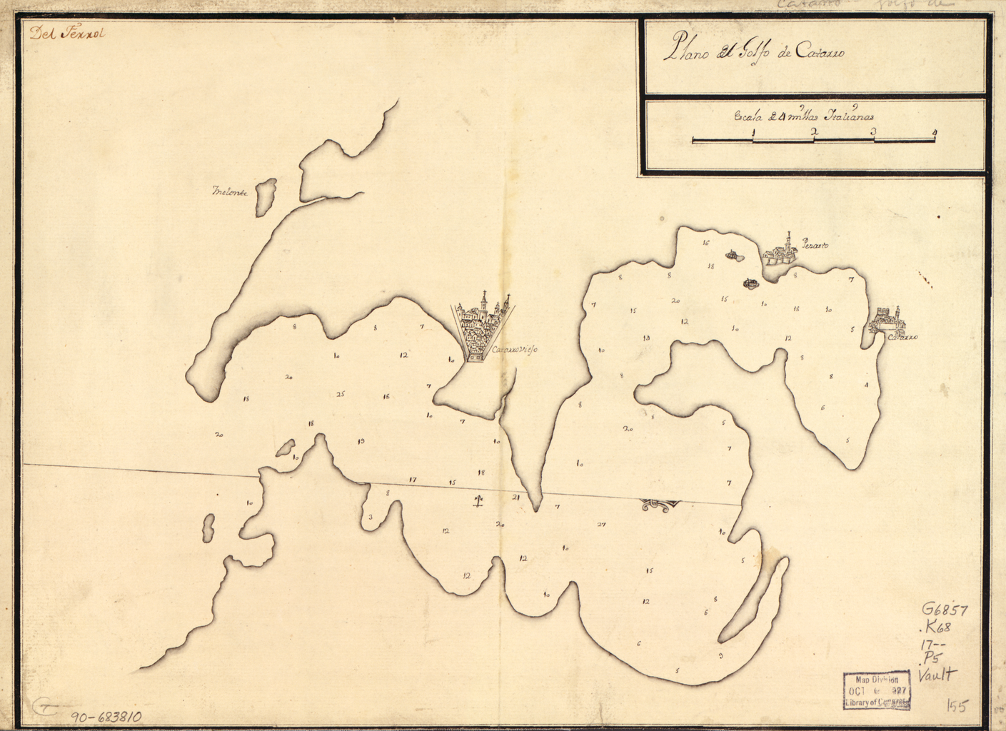
Русский: На данной испанской морской карте XVIII века изображен Которский залив — подобная фьорду водная масса в восточной части Адриатического моря. Эта карта входит в коллекцию испанских навигационных карт Библиотеки Конгресса, приобретенную у лондонской фирмы "Бриггз Брадерз". На карте показаны промеры глубины; карта ориентирована таким образом, что север находится в нижнем правом углу. Фраза "Дель Ферро" в верхнем левом углу относится к острову Ферро — самому южному в группе Канарских островов, который использовался в картах XVIII века в качестве нулевого меридиана. На карте также обозначен средневековый город Котор. У залива и города, расположенного на его берегу, долгая и непростая история, которая объясняется, главным образом, их стратегическим местоположением. В течение нескольких столетий Котор входил в состав различных средневековых государств: Османской империи, Венецианской республики, Наполеоновского королевства Италии, империи Габсбургов (ставшим позднее Австро-Венгерской империей), Королевства Сербов, Хорватов и Словенцев и государства Югославия. В настоящее время он является важным культурным и туристическим центром независимого государства Черногория.
Побережья; Которский залив (Черногория) Français : Cette carte maritime espagnole du 18ème siècle montre le golfe de Kotor, un emplacement d'eau de type fjord sur la côte orientale de la mer Adriatique. La carte fait partie de la collection de cartes de navigation espagnoles de la Bibliothèque du Congrès acquis auprès de Maggs Brothers, à Londres. La carte montre la mesure des profondeurs et est orientée avec le nord en bas à droite. La phrase "Del Ferro" situé dans le coin supérieur gauche se réfère à l'île de Ferro, la plus au sud-ouest des îles Canaries, utilisée dans les cartes du 18ème siècle en tant que premier méridien. On trouve également la ville médiévale de Kotor. Le golfe et la ville voisine ont eu une histoire longue et complexe, de part leur emplacement stratégique. Au fil des siècles, Kotor a fait partie de différents États médiévaux, l'Empire ottoman, la République de Venise, le royaume d'Italie de Napoléon, l'Empire des Habsbourg (côté austro-hongrois), le Royaume des Serbes, des Croates et des Slovènes, et l'état de Yougoslavie. Aujourd'hui, c'est un important centre culturel et touristique dans le pays indépendant du Monténégro.
Côtes; Kotor, Golfe de (Monténégro) English: This 18th-century Spanish maritime map shows the Gulf of Kotor, a fjord-like body of water located on the eastern side of the Adriatic Sea. The map is part of the Library of Congress’s collection of Spanish navigation maps, acquired from Maggs Brothers, London. The map shows depths in soundings and is oriented with north at the lower right. The phrase “Del Ferro” in the upper left refers to Ferro Island, the southwestern-most of the Canary Islands, that was used in 18th-century maps as the prime meridian. Also shown is the medieval city of Kotor. The gulf and the adjacent city have had a long and complex history, defined to a large extent by their strategic location. Over the centuries, Kotor was part of various medieval states, the Ottoman Empire, the Venetian Republic, the Napoleonic Kingdom of Italy, the Habsburg (later Austro-Hungarian) Empire, the Kingdom of Serbs, Croats, and Slovenes, and the state of Yugoslavia. Today, it is an important cultural and tourist center in the independent country of Montenegro.
Coasts; Kotor, Gulf of (Montenegro) 中文:这幅 18 世纪的西班牙海运地图上显示出了科托尔湾,科托尔湾是一片位于亚得里亚海东面的峡湾状水域。 该地图出自于美国国会图书馆收藏的西班牙航海地图,购买自伦敦马格斯兄弟。 该地图标注了探测水深,方向采用的是以右下角为北。 左上角的短语“Del Ferro”指的是菲尔洛岛,菲尔洛岛是加那利群岛的最西南端,18 世纪的地图中使用该岛屿作为本初子午线。 地图上还显示出了中世纪城市科托尔。 此处海湾以及邻近的城市都拥有悠久丰富的历史,这在很大程度上是因为它们所处位置的重要战略意义。 数百年来,科托尔隶属于众多中世纪国家,包括奥斯曼帝国、威尼斯共和国、拿破仑意大利王国、哈布斯堡帝国(后来的奥匈帝国)、塞尔维亚族、克罗地亚族和斯洛文尼亚王国以及南斯拉夫。 今天,它是独立国家黑山的一处重要的文化和旅游中心。
海岸; 科托尔湾(黑山) Português: Este mapa maritimo espanhol do século XVIII mostra o Golfo de Kotor, uma área recortada por água parecida com um fiorde, localizado no lado oriental do Mar Adriático. O mapa faz parte da coleção de mapas de navegação espanhóis da Biblioteca do Congresso, que foram adquiridos de Maggs Brothers, em Londres. O mapa mostra as profundidades dos estreitos e está orientado com o norte na parte inferior à direita. A frase "Del Ferro", na parte superior à esquerda, refere-se a Ilha Ferro, a ilha mais ao sudoeste dentre as ilhas Canárias, que era usada nos mapas do século XVIII como o meridiano principal. Também é mostrada a cidade medieval de Kotor. O golfo e a cidade adjacente tiveram uma história bastante longa e complexa definida, em grande parte, por sua localização estratégica. Por muitos séculos, Kotor fez parte de vários estados medievais, do Império Otomano, da República Veneziana, do Reino Napoleônico da Itália, do Império Habsburgo (mais tarde, Austro-Húngaro), do Reino dos Sérvios, Croatas e Eslovenos, e do estado da Iugoslávia. Hoje, é um importante centro cultural e turístico no país independente de Montenegro.
Litorais; Kotor, Golfo do (Montenegro) العربية: تظهر هذه الخريطة البحرية الإسبانية التي أُعدت في القرن الثامن عشر خليج كوتور، وهو عبارة عن زقاق بحري يقع على الجانب الشرقي من البحر الأدرياتيكي. والخريطة جزء من مجموعة مكتبة الكونغرس من الخرائط الملاحية الإسبانية، تم الحصول عليها من الإخوة ماغز من لندن. وتظهر الخريطة سبر الأغوار وهي موجهة بحيث تكون جهة الشمال في أسفل اليمين. وتشير عبارة "ديل فيرو" في الجزء العلوي من اليسار إلى جزر فيرو الواقعة في أقصى جنوب غرب جزر الكناري، التي كانت تُستخدم في خرائط القرن الثامن عشر كدائرة خط الطول الرئيسية. كما يظهر أيضا مدينة العصور الوسطى كوتور. وللخليج والمدينة المجاورة تاريخ طويل ومعقد، يقرره إلى حد كبير موقعهما الاستراتيجي. وعلى مدى قرون، كانت كوتور جزءًا من دول مختلفة في القرون الوسطى ومن الإمبراطورية العثمانية وجمهورية البندقية ومملكة نابليون في إيطاليا وامبراطورية الهابسبورغ (الامبراطورية النمساوية المجرية لاحقًا) ومملكة الصرب والكروات والسلوفينيين ودولة يوغوسلافيا. وهي اليوم مركز ثقافي وسياحي هام في دولة الجبل الأسود المستقلة.
السواحل; كوتور، خليج (مونتينيغرو) Español: Este mapa marítimo español del siglo XVIII muestra el Golfo de Kotor, un cuerpo de agua tipo fiordo situado en la parte oriental del mar Adriático. El mapa es parte de la colección de mapas de navegación en español de la Biblioteca del Congreso, adquiridos de los Hermanos Maggs de Londres. El mapa muestra profundidades en sondeos y se orienta con el norte en la parte inferior derecha. La frase "Del Ferro" en la parte superior izquierda se refiere a la isla de Ferro, la isla más al suroeste de las islas Canarias, que se utilizó en los mapas del siglo XVIII como el primer meridiano. También se muestra la ciudad medieval de Kotor. El golfo y la ciudad adyacente han tenido una larga y compleja historia, que se define en gran medida por su ubicación estratégica. Durante siglos, Kotor fue parte de varios estados medievales, el Imperio Otomano, la República de Venecia, el napoleónico Reino de Italia, el Imperio Habsburgo (luego Austro-Húngaro), el Reino de los Serbios, Croatas y Eslovenos y el estado de Yugoslavia. En la actualidad, es un importante centro cultural y turístico en el país independiente de Montenegro.
Costas; Kotor, Golfo de (Montenegro) |
| Date | 1700 |
| Medium |
Русский: Карты
Français : Cartes
English: Maps
中文:地图
Português: Mapas
العربية: خرائط
Español: Mapas |
| Dimensions |
English: 1 manuscript map ; 27 x 36 centimeters |
| Collection |
Русский: Библиотека Конгресса
Français : Bibliothèque du Congrès
English: Library of Congress
中文:国会图书馆
Português: Biblioteca do Congresso
العربية: مكتبة الكونغرس
Español: Biblioteca del Congreso |
| Place of creation |
Русский: Сербия
Français : Serbie
English: Serbia
中文:塞尔维亚
Português: Sérvia
العربية: صربيا
Español: Serbia |
| Notes | Original language title: Plano del Golfo de Catarro |
| References | http://hdl.loc.gov/loc.wdl/dlc.472 |
| Source/Photographer |
|
Licensing edit
|
This is a faithful photographic reproduction of a two-dimensional, public domain work of art. The work of art itself is in the public domain for the following reason:
The official position taken by the Wikimedia Foundation is that "faithful reproductions of two-dimensional public domain works of art are public domain".
This photographic reproduction is therefore also considered to be in the public domain in the United States. In other jurisdictions, re-use of this content may be restricted; see Reuse of PD-Art photographs for details. | ||||
File history
Click on a date/time to view the file as it appeared at that time.
| Date/Time | Thumbnail | Dimensions | User | Comment | |
|---|---|---|---|---|---|
| current | 18:05, 11 March 2014 | | 1,409 × 1,024 (2.04 MB) | Fæ (talk | contribs) | =={{int:filedesc}}== {{Artwork |artist = |author = |title ={{ru|1=Карта залива Катарро}} {{fr|1=Carte du Golfe de Catarro}} {{en|1=Map of the Gulf of Catarro}} {{zh|1=卡塔罗湾地图}} {{pt|1=Mapa do Golfo do Catarro}} {{ar|1=خر... |
You cannot overwrite this file.
File usage on Commons
The following page uses this file: