File:Map of the Hathaway Academy.png

Size of this preview: 759 × 600 pixels. Other resolutions: 304 × 240 pixels | 608 × 480 pixels | 972 × 768 pixels | 1,280 × 1,011 pixels | 1,477 × 1,167 pixels.
Original file (1,477 × 1,167 pixels, file size: 227 KB, MIME type: image/png)
Captions
Captions
Add a one-line explanation of what this file represents
Summary edit
| Description |
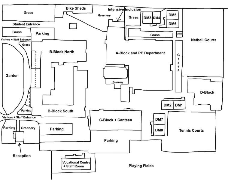
English: A map of the Hathaway Academy in Grays, Essex, England. Note that this map is based on info found online, satellite imagery and this https://web.archive.org/web/20120401223554/http://www.thegrays.thurrock.sch.uk/wpimages/wp10cd5b6e_05_06.jpg. Therefore this map may hold some inaccuracies. |
| Date | |
| Source | Own work |
| Author | ThatRandomGuy1 |
Licensing edit
I, the copyright holder of this work, hereby publish it under the following license:
This file is licensed under the Creative Commons Attribution-Share Alike 4.0 International license.
- You are free:
- to share – to copy, distribute and transmit the work
- to remix – to adapt the work
- Under the following conditions:
- attribution – You must give appropriate credit, provide a link to the license, and indicate if changes were made. You may do so in any reasonable manner, but not in any way that suggests the licensor endorses you or your use.
- share alike – If you remix, transform, or build upon the material, you must distribute your contributions under the same or compatible license as the original.
File history
Click on a date/time to view the file as it appeared at that time.
| Date/Time | Thumbnail | Dimensions | User | Comment | |
|---|---|---|---|---|---|
| current | 00:47, 12 December 2021 | | 1,477 × 1,167 (227 KB) | ThatRandomGuy1 (talk | contribs) | Uploaded own work with UploadWizard |
You cannot overwrite this file.
File usage on Commons
There are no pages that use this file.
File usage on other wikis
The following other wikis use this file:
- Usage on en.wikipedia.org