File:Map of the MENA region in 1798.svg

Size of this PNG preview of this SVG file: 800 × 522 pixels. Other resolutions: 320 × 209 pixels | 640 × 417 pixels | 1,024 × 668 pixels | 1,280 × 835 pixels | 2,560 × 1,669 pixels | 1,543 × 1,006 pixels.
Original file (SVG file, nominally 1,543 × 1,006 pixels, file size: 528 KB)
Captions
Captions
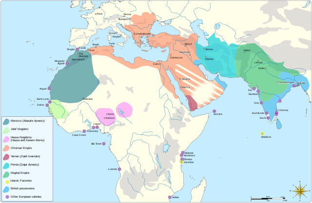
The MENA region in 1798
Summary edit
| Description |
English: Map showing the political entities of the Middle East and North Africa in 1798, namely: the Alaouite dynasty, the Kingdom of Jolof, the Hausa Kingdoms, the Ottoman empire, the Yemeni Zaidi State, the Qajar dynasty and the Mughal Empire. |
| Date | |
| Source |
Own work Information from: |
| Author | Goran tek-en, following request by and knowledge from Flaspec |
| Permission (Reusing this file) |
This file is licensed under the Creative Commons Attribution-Share Alike 4.0 International license. Attribution: Goran tek-en
|
| Other versions |
|
| SVG development | This vector image was created with Inkscape. |

| Object location | | View this and other nearby images on: OpenStreetMap |
|---|
File history
Click on a date/time to view the file as it appeared at that time.
| Date/Time | Thumbnail | Dimensions | User | Comment | |
|---|---|---|---|---|---|
| current | 10:03, 4 May 2021 | | 1,543 × 1,006 (528 KB) | Goran tek-en (talk | contribs) | Change in legend requested by Flaspec |
| 09:21, 3 May 2021 |  | 1,543 × 1,006 (528 KB) | Goran tek-en (talk | contribs) | {{Information |description ={{en|Map showing the political entities of the Middle East and North Africa in 1798.}} |date =2021-05-03 |source ={{Own}}<br> {{Derived from|امتداد الدولة العلوية سنة 1798م.png|BlankMap-World-Compact.svg}} Information from: * [http://medias.sciences-po.fr/Lexpansion_europeenne_1798/medias/domain2/media0/133-0glgaklmem-whr.jpg 1798] * {{U|Flaspec}} |author =Goran tek-en, following request by... |
You cannot overwrite this file.
File usage on Commons
The following 2 pages use this file:
File usage on other wikis
The following other wikis use this file:
- Usage on ar.wikipedia.org
- Usage on fr.wikipedia.org