File:Map of the Oberämter of the Electoral Palatinate (1789) - Numbered.svg

Size of this PNG preview of this SVG file: 800 × 545 pixels. Other resolutions: 320 × 218 pixels | 640 × 436 pixels | 1,024 × 698 pixels | 1,280 × 873 pixels | 2,560 × 1,745 pixels | 3,770 × 2,570 pixels.
Original file (SVG file, nominally 3,770 × 2,570 pixels, file size: 532 KB)
Captions
Captions
Add a one-line explanation of what this file represents
Summary edit
_-_Numbered.svg&action=edit§ion=1)
| Description |
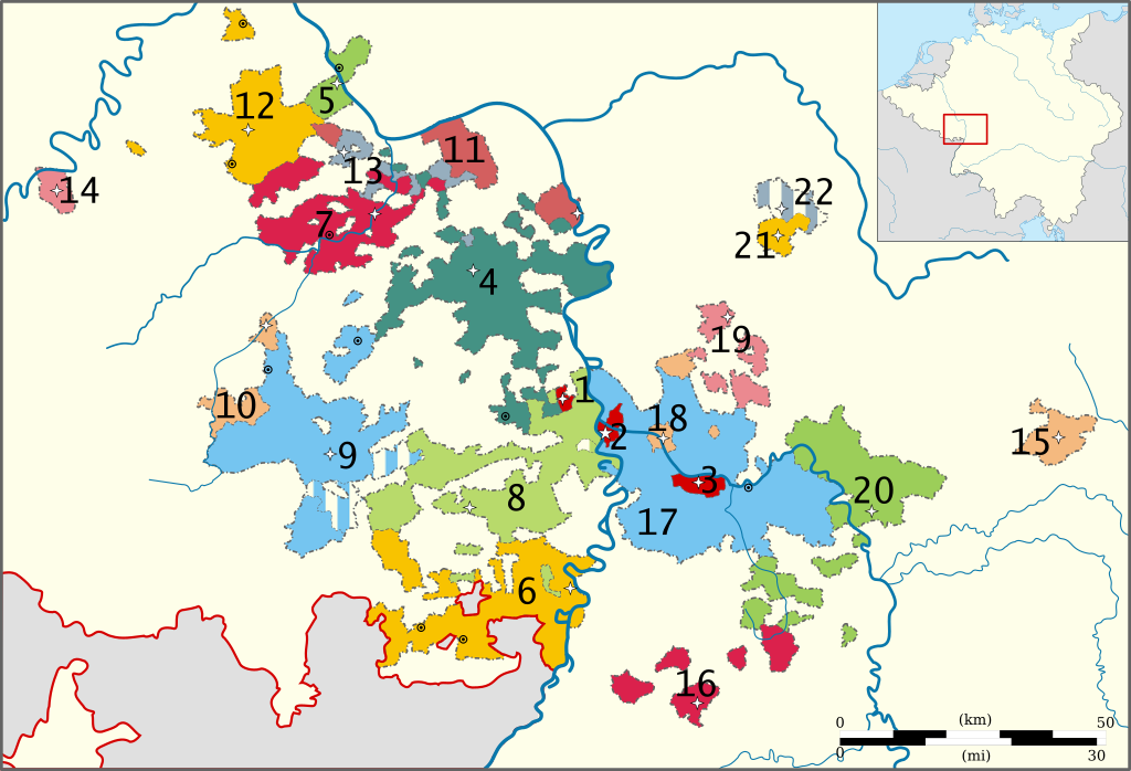
English: Map of the administrative divisions (Oberämter) and subdivisions of the Electorate of the Palatinate in 1789.
Deutsch: Karte der Kurpfalz 1789.
Stadtämter:
Oberämter:
|
| Date | |
| Source | Own work, based on a map from the Heidelberg University website. Orginal from Pfalzatlas. |
| Author | Universität Heidelberg, reworked by Sir Iain and Lencer (Inset map of the Empire) |
| Permission (Reusing this file) |
Copyright: Universität Heidelberg (see: https://www.uni-heidelberg.de/fakultaeten/philosophie/zegk/vlgk/orte/gemeinden.html) |
Licensing edit
_-_Numbered.svg&action=edit§ion=2)
I, the copyright holder of this work, hereby publish it under the following licenses:
This file is licensed under the Creative Commons Attribution-Share Alike 3.0 Unported license.
- You are free:
- to share – to copy, distribute and transmit the work
- to remix – to adapt the work
- Under the following conditions:
- attribution – You must give appropriate credit, provide a link to the license, and indicate if changes were made. You may do so in any reasonable manner, but not in any way that suggests the licensor endorses you or your use.
- share alike – If you remix, transform, or build upon the material, you must distribute your contributions under the same or compatible license as the original.

|
Permission is granted to copy, distribute and/or modify this document under the terms of the GNU Free Documentation License, Version 1.2 or any later version published by the Free Software Foundation; with no Invariant Sections, no Front-Cover Texts, and no Back-Cover Texts. A copy of the license is included in the section entitled GNU Free Documentation License. |
You may select the license of your choice.
File history
Click on a date/time to view the file as it appeared at that time.
| Date/Time | Thumbnail | Dimensions | User | Comment | |
|---|---|---|---|---|---|
| current | 14:41, 12 November 2010 | | 3,770 × 2,570 (532 KB) | Sir Iain (talk | contribs) | {{Information |Description={{en|1=Map of the Political subdivisions (''Oberämter'') of the Electoral Palatinate in 1789.}} |Source={{own}}, based on a map from [http://www.uni-heidelberg.de/fakultaeten/philosophie/zegk/fpi/karte.html the Heidelberg Unive |
You cannot overwrite this file.
File usage on Commons
There are no pages that use this file.
File usage on other wikis
The following other wikis use this file:
- Usage on bg.wikipedia.org
- Usage on ca.wikipedia.org
- Usage on de.wikipedia.org
- Usage on en.wikipedia.org
- Usage on eo.wikipedia.org
- Usage on es.wikipedia.org
- Usage on et.wikipedia.org
- Usage on he.wikipedia.org
- Usage on id.wikipedia.org
- Usage on it.wikipedia.org
- Usage on ja.wikipedia.org
- Usage on nl.wikipedia.org
- Usage on no.wikipedia.org
- Usage on pt.wikipedia.org
- Usage on sh.wikipedia.org
- Usage on sv.wikipedia.org
- Usage on vi.wikipedia.org
_-_Numbered.svg&oldid=849502843)