File:Map of the Sea WDL3037.png
Size of this preview: 800 × 539 pixels. Other resolutions: 320 × 215 pixels | 640 × 431 pixels | 1,024 × 689 pixels | 1,280 × 862 pixels | 1,521 × 1,024 pixels.
Original file (1,521 × 1,024 pixels, file size: 3.31 MB, MIME type: image/png)
Captions
Captions
Add a one-line explanation of what this file represents
Summary edit
| Русский: Карта моря
Français : Carte maritime English: Map of the Sea 中文:海洋地图 Português: Mapa do Mar العربية: خريطة للبحر Español: Mapa del mar |
|
|---|---|
| Author |
Русский: Магнус, Олаус (1490-1557)
Français : Magnus, Olaus (1490-1557)
English: Magnus, Olaus (1490-1557)
中文:马格纳斯, 奥拉斯 (1490-1557)
Português: Magnus, Olaus (1490-1557)
العربية: ماغنوس, أولاوس (1490-1557)
Español: Magnus, Olaus (1490-1557) |
| Title |
Русский: Карта моря
Français : Carte maritime
English: Map of the Sea
中文:海洋地图
Português: Mapa do Mar
العربية: خريطة للبحر
Español: Mapa del mar |
| Description |
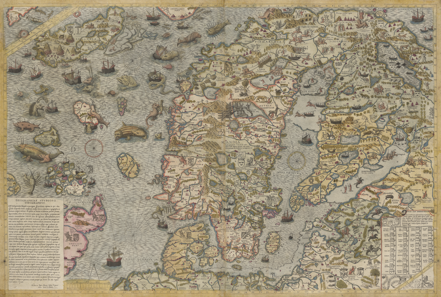
Русский: "Carta marina" шведского географа и историка Олауса Магнуса является одним из самых ранних точных картографических изображений скандинавского полуострова. Изображение создано в Риме в 1539 году одним из самых выдающихся священнослужителей Скандинавии и содержит множество деталей, которые отсутствовали в ранних картах этого региона. Первоначально карта предназначалась для "Historia de gentibus septentrionalibus" ("Описания северных народов") и была издана примерно за 15 лет до появления этой грандиозной работы. Считается, что Олаус Магнус был первым, кто предложил идею создания Северо-Восточного прохода. Это второе издание карты, опубликованное Антуаном Лафери в 1572 году.
Скандинавия Français : La Carta marina du géographe et historien suédois Olaus Magnus est l'une des toutes premières représentations géographiques exactes de la péninsule scandinave. Dressée à Rome en 1539, par l'un des catholiques scandinaves les plus importants et occupant un poste ecclésiastique prestigieux, elle contient des détails qui sont omis dans bien des cartes antérieures de la région. Initialement destinée pour son Historia de gentibus septentrionalibus (Une description des peuples du Nord), la carte fut publiée quelques 15 ans avant l'apparition de cette œuvre majestueuse. Olaus Magnus est généralement considéré comme le premier à avancer l'idée d'un Passage nord-oriental. Il s'agit de la seconde édition de cette carte, publiée par Antoine Lafréry en 1572.
Scandinavie English: The Carta marina of the Swedish geographer and historian Olaus Magnus is one of the earliest accurate cartographic depictions of the Scandinavian peninsula. Drafted in Rome in 1539, by one of the more prominent Scandinavian Catholics in higher ecclesiastical service, it contains detail that is lacking in many other early maps of the region. Originally intended for his Historia de gentibus septentrionalibus (A description of the Nordic peoples), the map was published some 15 years before the appearance of this majestic work. Olaus Magnus is generally regarded as the first to propound the idea of a Northeast Passage. This is the second edition of this map, published by Antoine Lafréry in 1572.
Scandinavia 中文:这幅 《Carta marina》地图 出自瑞典地理学家兼历史学家奥拉斯·马格努斯之手,是最早精确描绘斯堪的纳维亚半岛的地图之一。 这幅地图 1539 年在罗马由拥有更高教会职务的斯堪的纳维亚天主教教会成员绘制草图,因此其中包含有很多其他该地区早期地图中所没有的详细信息。 该地图绘制的初衷是为了他的著作 《瑞典人和汪达尔人的历史(Historia de gentibus septentrionalibus)》 (介绍北欧民族),该地图约早于该部巨著 15 年出版问世。 人们普遍认为奥拉斯·马格努斯是首位提出东北航道的人。 这幅地图是该地图的第二版,由 Antoine Lafréry 在 1572 年出版。
斯堪的纳维亚 Português: A Carta marina do geógrafo e historiador sueco Olaus Magnus é uma das primeiras representações cartográficas precisas da península escandinava. Desenhada em Roma em 1539, por um dos mais proeminentes escandinavos católicos do mais alto nível eclesiástico, contém detalhes que faltam em muitos dos outros mapas pioneiros da região. Inicialmente prevista para a sua Historia de gentibus septentrionalibus (Uma descrição dos povos nórdicos), o mapa foi publicado por volta de 15 anos antes do aparecimento desta magnífica obra. Olaus Magnus é geralmente considerado o primeiro a propor a idéia da Passagem do Noroeste. Esta é a segunda edição deste mapa, publicada por Antoine Lafréry em 1572.
Escandinávia العربية: تُعتبر الكارتا مارينا للجغرافي والمؤرخ السويدي أولاوس ماغنوس إحدى أبكر التصويرات الدقيقة لشبه الجزرية الإسكندينافية وقد وضعت صيغتها في روما في عام 1539، على يد أحد أبرز الكاثوليكيين الإسكندينافيين في المرتبات العالية للخدمة الكنسية، إذ تحتوي على تفاصيل قلما توجد في العديد من الخرائط المبكرة لتلك المنطقة. كان الهدف الأصلي منها درجها في عمله هيستوريا دي جينتيبوس سيبتنتريوناليبوس (وصف للشعوب الشمالية)، ألا أنها نُشرت حوالي 15 سنة قبل ظهور عمله الجبار. كما يُعتبر أولاوس ماغنوس أول من عرض فكرة ممر شمالي شرقي. أما هذه النسخة فهي الطبعة الثانية للخريطة وكان قد نشرها أنطوان لافريري في عام 1572.
الدول الاسكندنافية Español: La Carta marina del historiador y geógrafo sueco Olaus Magnus es una de las primeras representaciones cartográficas precisas de la península escandinava. Elaborada en Roma en 1539 por uno de los más prominentes católicos escandinavos del servicio eclesiástico superior, contiene detalles que faltan en muchos otros mapas de la región. Originalmente destinado a su Historia de gentibus septentrionalibus (Una descripción de los pueblos nórdicos), el mapa fue publicado unos 15 años antes de la aparición de esta majestuosa obra. Olaus Magnus es generalmente considerado como el primero en proponer la idea de un paso del noreste. Esta es la segunda edición de este mapa, publicado por Antoine Lafréry en 1572.
Escandinavia |
| Date | 1572 |
| Medium |
Русский: Карты
Français : Cartes
English: Maps
中文:地图
Português: Mapas
العربية: خرائط
Español: Mapas |
| Dimensions |
English: 1 map on 2 sheets joined together: copper engraving, color, 52 x 79 centimeters |
| Collection |
Русский: Национальная библиотека Швеции
Français : Bibliothèque nationale de Suède
English: National Library of Sweden
中文:瑞典国家图书馆
Português: Biblioteca Nacional da Suécia
العربية: مكتبة السويد الوطنية
Español: Biblioteca Nacional de Suecia |
| Place of creation |
Русский: Финляндия
Français : Finlande
English: Finland
中文:芬兰
Português: Finlândia
العربية: فنلندا
Español: Finlandia |
| Notes |
Original language title: [Carta marina] Русский: Масштаб 1:3 700 000
Français : Échelle 1:3 700 000
English: Scale 1:3,700,000
中文:比例尺 1:3,700,000
Português: Escala 1:3,700,000
العربية: مقياس 1:3,700,000
Español: Escala 1:3.700.000 |
| References | http://hdl.loc.gov/loc.wdl/swskb.3037 |
| Source/Photographer |
|
Licensing edit
|
This is a faithful photographic reproduction of a two-dimensional, public domain work of art. The work of art itself is in the public domain for the following reason:
The official position taken by the Wikimedia Foundation is that "faithful reproductions of two-dimensional public domain works of art are public domain".
This photographic reproduction is therefore also considered to be in the public domain in the United States. In other jurisdictions, re-use of this content may be restricted; see Reuse of PD-Art photographs for details. | ||||
File history
Click on a date/time to view the file as it appeared at that time.
| Date/Time | Thumbnail | Dimensions | User | Comment | |
|---|---|---|---|---|---|
| current | 13:58, 11 March 2014 | | 1,521 × 1,024 (3.31 MB) | Fæ (talk | contribs) | =={{int:filedesc}}== {{Artwork |artist = |author ={{ru|1=Магнус, Олаус (1490-1557)}} {{fr|1=Magnus, Olaus (1490-1557)}} {{en|1=Magnus, Olaus (1490-1557)}} {{zh|1=马格纳斯, 奥拉斯 (1490-1557)}} {{pt|1=Magnus, Olaus (1490-1557)}} {{ar|1... |
You cannot overwrite this file.
File usage on Commons
The following page uses this file: