File:Map of the Siege of Quebec, from page 341 of "The siege of Quebec and the battle of the Plains of Abraham" (1901).jpg

Original file (2,032 × 2,428 pixels, file size: 484 KB, MIME type: image/jpeg)
Captions
Captions
Summary edit
.jpg&action=edit§ion=1)
| Description |
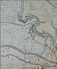
This is a small part (about one eight) of a map titled "Plan of the town of Quebec, the capital of Canada in North America, with the Bason and a part of the adjacent country shewing the principal encampments and works of the British army commanded by major general Wolfe, and those of the French army commanded by lieut general the marquis of Montcalm, during the siege of that place in 1759."
Click here to view book online to see this illustration in context in a browseable online version of this book.
Text Appearing After Image: 4i <» .«J. «* 48 ..^^ Efl 2.e K A. d 1 Coast of BKAUPOKT. Tescent 6t Qie Britisli Troops upon theC.wst of BKAITPORT the 31 July Vid Journal — BATTLE of y« 13 Sept upon the HAUTEUKD ABRAHAM gained by the British -.Troops over the French —Vid Journal tt, liattory enctod hy tlio Frenoli to annoy MontmorencyCamp hut novor used. N. B. Tlio Kncampmciits of theFrench did not consist at any one time of the number laiddown but Shifted occasionally at convouieucy required. e, Place whore the British Troops landed. /, Two Kai srun aground at high water to favour the Descent mountini;14 Gunseach. {/, Redoubt which the EfufWrryabandonedand we took possession of. /*, The Centurion a 60 GnuShip which was to have silenced the Redoubt, i, k, Passageof two Brigades from Montmorency Camp across the Fordat low water, who retreated the same way, the other Troopshaving been called off. rt, The places where the British Troops landed nearFoulon, the landing began about four in the morning andended
|
| Date | |
| Source | Image from page 341 of "The siege of Quebec and the battle of the Plains of Abraham" (1901), Internet Archive Book Images |
| Author | Map copyright by A.G. Doughty, 1900. Made after various sources. |
| Permission (Reusing this file) |
Internet Archive Book Images @ Flickr Commons |
| Other versions |
An image of the whole map, but in smaller resolution:.jpg) |
Status edit
.jpg&action=edit§ion=2)
This work is in the public domain in the United States because it was published (or registered with the U.S. Copyright Office) before January 1, 1929.
Public domain works must be out of copyright in both the United States and in the source country of the work in order to be hosted on the Commons. If the work is not a U.S. work, the file must have an additional copyright tag indicating the copyright status in the source country.
Note: This tag should not be used for sound recordings. |
This Canadian work is in the public domain in Canada because its copyright has expired due to one of the following:
it was not subject to Crown copyright, and
|
 |
Licensing edit
.jpg&action=edit§ion=3)
This image was taken from Flickr's The Commons. The uploading organization may have various reasons for determining that no known copyright restrictions exist, such as:
More information can be found at https://flickr.com/commons/usage/. Please add additional copyright tags to this image if more specific information about copyright status can be determined. See Commons:Licensing for more information. |
| This image was originally posted to Flickr by Internet Archive Book Images at https://flickr.com/photos/126377022@N07/14743651806. It was reviewed on 11 October 2018 by FlickreviewR 2 and was confirmed to be licensed under the terms of the No known copyright restrictions. |
File history
Click on a date/time to view the file as it appeared at that time.
| Date/Time | Thumbnail | Dimensions | User | Comment | |
|---|---|---|---|---|---|
| current | 22:30, 11 October 2018 | | 2,032 × 2,428 (484 KB) | Geo Swan (talk | contribs) | =={{int:filedesc}}== {{Information |Description='''Identifier''': siegeofquebec01doug '''Title''': [https://www.flickr.com/photos/internetarchivebookimages/tags/bookidsiegeofquebec01doug The siege of Quebec and the battle of the Plains of Abraham] '''Year''': [https://www.flickr.com/photos/internetarchivebookimages/tags/bookyear1901 1901] ([https://www.flickr.com/photos/internetarchivebookimages/tags/bookdecade1900 1900s]) '''Authors''': [https://www.flickr.com/photos/internetarchivebookimag... |
You cannot overwrite this file.
File usage on Commons
There are no pages that use this file.
.jpg&oldid=688764039)