File:Map of the Tennessee River for the Use of the Mississippi Squadron under Command of, p. 17 of 18 - NARA - 305691.jpg

Original file (3,533 × 4,511 pixels, file size: 13.55 MB, MIME type: image/jpeg)
Captions
Captions
Summary edit
| Author |
Unknown author or not provided |
||||||||||||||||||||||||||
| Record creator | War Department. Office of the Chief of Engineers. (1818 - 09/18/1947) | ||||||||||||||||||||||||||
| Title |
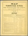
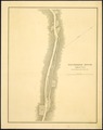
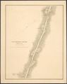
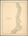
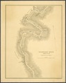
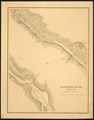
Map of the Tennessee River for the Use of the Mississippi Squadron under Command of Acting Rear Admiral S. P. Lee, U.S.N., From Reconnaissance by a party of the United States Coast Survey [under F. H. Gerdes] . . . 1864-1865. |
||||||||||||||||||||||||||
| Date | circa 1865 | ||||||||||||||||||||||||||
| Collection |
|
||||||||||||||||||||||||||
| Record ID |
|
||||||||||||||||||||||||||
| Source | U.S. National Archives and Records Administration | ||||||||||||||||||||||||||
| Other versions |
Please do not overwrite this file: any restoration work should be uploaded with a new name and linked in this page's "other versions=" parameter, so that this file represents the exact file found in the NARA catalog record to which it links. The metadata on this page was imported directly from NARA's catalog record; additional descriptive text may be added by Wikimedians to the template below with the "description=" parameter, but please do not modify the other fields.
|
||||||||||||||||||||||||||
| Other pages |
|
||||||||||||||||||||||||||


Licensing edit
This file was provided to Wikimedia Commons by the National Archives and Records Administration as part of a cooperation project. The National Archives and Records Administration provides images depicting American and global history which are public domain or licensed under a free license.
|
This work is in the public domain in the United States because it is a work prepared by an officer or employee of the United States Government as part of that person’s official duties under the terms of Title 17, Chapter 1, Section 105 of the US Code.
Note: This only applies to original works of the Federal Government and not to the work of any individual U.S. state, territory, commonwealth, county, municipality, or any other subdivision. This template also does not apply to postage stamp designs published by the United States Postal Service since 1978. (See § 313.6(C)(1) of Compendium of U.S. Copyright Office Practices). It also does not apply to certain US coins; see The US Mint Terms of Use.
|
 | |
| This file has been identified as being free of known restrictions under copyright law, including all related and neighboring rights. | ||
File history
Click on a date/time to view the file as it appeared at that time.
| Date/Time | Thumbnail | Dimensions | User | Comment | |
|---|---|---|---|---|---|
| current | 19:05, 10 May 2014 | | 3,533 × 4,511 (13.55 MB) | US National Archives bot (talk | contribs) | == {{int:filedesc}} == {{NARA-image-full |Title=Map of the Tennessee River for the Use of the Mississippi Squadron under Command of Acting Rear Admiral S. P. Lee, U.S.N., From Reconnaissance by a party of the United States Coast Survey <nowiki>[</nowik... |
You cannot overwrite this file.
File usage on Commons
The following 36 pages use this file:
- File:Map of the Tennessee River for the Use of the Mississippi Squadron under Command of, p. 10 of 18 - NARA - 305691.jpg
- File:Map of the Tennessee River for the Use of the Mississippi Squadron under Command of, p. 10 of 18 - NARA - 305691.tif
- File:Map of the Tennessee River for the Use of the Mississippi Squadron under Command of, p. 11 of 18 - NARA - 305691.jpg
- File:Map of the Tennessee River for the Use of the Mississippi Squadron under Command of, p. 11 of 18 - NARA - 305691.tif
- File:Map of the Tennessee River for the Use of the Mississippi Squadron under Command of, p. 12 of 18 - NARA - 305691.jpg
- File:Map of the Tennessee River for the Use of the Mississippi Squadron under Command of, p. 12 of 18 - NARA - 305691.tif
- File:Map of the Tennessee River for the Use of the Mississippi Squadron under Command of, p. 13 of 18 - NARA - 305691.jpg
- File:Map of the Tennessee River for the Use of the Mississippi Squadron under Command of, p. 13 of 18 - NARA - 305691.tif
- File:Map of the Tennessee River for the Use of the Mississippi Squadron under Command of, p. 14 of 18 - NARA - 305691.jpg
- File:Map of the Tennessee River for the Use of the Mississippi Squadron under Command of, p. 14 of 18 - NARA - 305691.tif
- File:Map of the Tennessee River for the Use of the Mississippi Squadron under Command of, p. 15 of 18 - NARA - 305691.jpg
- File:Map of the Tennessee River for the Use of the Mississippi Squadron under Command of, p. 15 of 18 - NARA - 305691.tif
- File:Map of the Tennessee River for the Use of the Mississippi Squadron under Command of, p. 16 of 18 - NARA - 305691.jpg
- File:Map of the Tennessee River for the Use of the Mississippi Squadron under Command of, p. 16 of 18 - NARA - 305691.tif
- File:Map of the Tennessee River for the Use of the Mississippi Squadron under Command of, p. 17 of 18 - NARA - 305691.jpg
- File:Map of the Tennessee River for the Use of the Mississippi Squadron under Command of, p. 17 of 18 - NARA - 305691.tif
- File:Map of the Tennessee River for the Use of the Mississippi Squadron under Command of, p. 18 of 18 - NARA - 305691.jpg
- File:Map of the Tennessee River for the Use of the Mississippi Squadron under Command of, p. 18 of 18 - NARA - 305691.tif
- File:Map of the Tennessee River for the Use of the Mississippi Squadron under Command of, p. 1 of 18 - NARA - 305691.jpg
- File:Map of the Tennessee River for the Use of the Mississippi Squadron under Command of, p. 1 of 18 - NARA - 305691.tif
- File:Map of the Tennessee River for the Use of the Mississippi Squadron under Command of, p. 2 of 18 - NARA - 305691.jpg
- File:Map of the Tennessee River for the Use of the Mississippi Squadron under Command of, p. 2 of 18 - NARA - 305691.tif
- File:Map of the Tennessee River for the Use of the Mississippi Squadron under Command of, p. 3 of 18 - NARA - 305691.jpg
- File:Map of the Tennessee River for the Use of the Mississippi Squadron under Command of, p. 3 of 18 - NARA - 305691.tif
- File:Map of the Tennessee River for the Use of the Mississippi Squadron under Command of, p. 4 of 18 - NARA - 305691.jpg
- File:Map of the Tennessee River for the Use of the Mississippi Squadron under Command of, p. 4 of 18 - NARA - 305691.tif
- File:Map of the Tennessee River for the Use of the Mississippi Squadron under Command of, p. 5 of 18 - NARA - 305691.jpg
- File:Map of the Tennessee River for the Use of the Mississippi Squadron under Command of, p. 5 of 18 - NARA - 305691.tif
- File:Map of the Tennessee River for the Use of the Mississippi Squadron under Command of, p. 6 of 18 - NARA - 305691.jpg
- File:Map of the Tennessee River for the Use of the Mississippi Squadron under Command of, p. 6 of 18 - NARA - 305691.tif
- File:Map of the Tennessee River for the Use of the Mississippi Squadron under Command of, p. 7 of 18 - NARA - 305691.jpg
- File:Map of the Tennessee River for the Use of the Mississippi Squadron under Command of, p. 7 of 18 - NARA - 305691.tif
- File:Map of the Tennessee River for the Use of the Mississippi Squadron under Command of, p. 8 of 18 - NARA - 305691.jpg
- File:Map of the Tennessee River for the Use of the Mississippi Squadron under Command of, p. 8 of 18 - NARA - 305691.tif
- File:Map of the Tennessee River for the Use of the Mississippi Squadron under Command of, p. 9 of 18 - NARA - 305691.jpg
- File:Map of the Tennessee River for the Use of the Mississippi Squadron under Command of, p. 9 of 18 - NARA - 305691.tif