File:Map of the battle of Malvern Hill, showing, approximately, positions of brigades and batteries. (July 1, 1862). LOC 99439181.jpg

Size of this preview: 453 × 600 pixels. Other resolutions: 181 × 240 pixels | 362 × 480 pixels | 580 × 768 pixels | 773 × 1,024 pixels | 1,547 × 2,048 pixels | 2,596 × 3,437 pixels.
Original file (2,596 × 3,437 pixels, file size: 1.4 MB, MIME type: image/jpeg)
Captions
Captions
Add a one-line explanation of what this file represents
Summary edit
| Description |
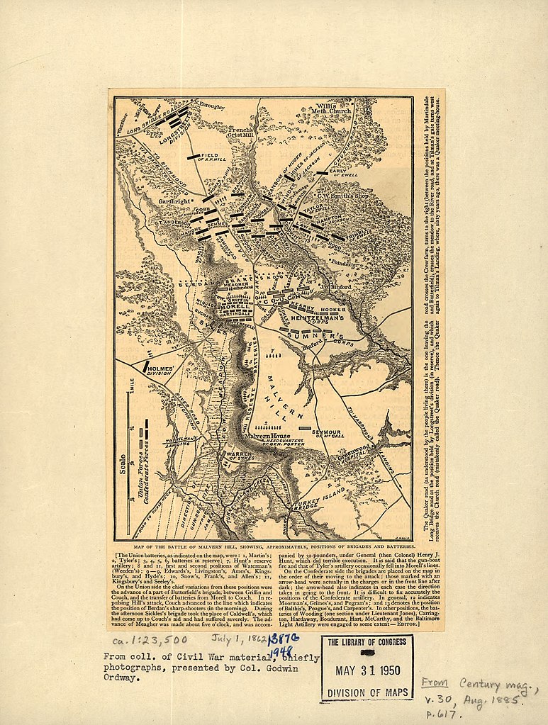
English: Scale ca. 1:23,500. LC Civil War Maps (2nd ed.), 560 From Century illustrated monthly magazine, v. 30, Aug. 1885. p. 617. Gives names of commanders, roads, drainage, vegetation, relief by hachures, houses, and names of residents. Brief description of the battle appears below the map. Description derived from published bibliography. Available also through the Library of Congress web site as raster image. |
||
| Title | Map of the battle of Malvern Hill, showing, approximately, positions of brigades and batteries. [July 1, 1862]. | ||
| Shelf ID | G3882.M28S5 1862 .W4 | ||
| Date | |||
| Source | https://www.loc.gov/item/99439181/ | ||
| Author | Wells, Jacob | ||
| Permission (Reusing this file) |
|
||
| Other versions |
|
||
| Location | United States · Malvern Hill · Virginia | ||
| Part of | Military Battles And Campaigns · American Memory · Civil War Maps · Catalog · Geography And Map Division | ||
| Subject | United States · Malvern Hill · Virginia · Malvern Hill, Battle Of, Va. · Malvern Hill (Va.), Battle Of |

._LOC_99439181.jpg&action=edit§ion=1)
Licensing edit
._LOC_99439181.jpg&action=edit§ion=2)
|
This is a faithful photographic reproduction of a two-dimensional, public domain work of art. The work of art itself is in the public domain for the following reason:
The official position taken by the Wikimedia Foundation is that "faithful reproductions of two-dimensional public domain works of art are public domain".
This photographic reproduction is therefore also considered to be in the public domain in the United States. In other jurisdictions, re-use of this content may be restricted; see Reuse of PD-Art photographs for details. | ||||
File history
Click on a date/time to view the file as it appeared at that time.
| Date/Time | Thumbnail | Dimensions | User | Comment | |
|---|---|---|---|---|---|
| current | 03:57, 20 May 2018 | | 2,596 × 3,437 (1.4 MB) | Fæ (talk | contribs) | LOC Maps https://www.loc.gov/item/99439181/ #12008 |
You cannot overwrite this file.
File usage on Commons
The following page uses this file:
._LOC_99439181.jpg&oldid=739380364)