File:Map of the central portion of Baltimore City LOC 2002620191.tif

Size of this JPG preview of this TIF file: 386 × 599 pixels. Other resolutions: 154 × 240 pixels | 309 × 480 pixels | 495 × 768 pixels | 660 × 1,024 pixels | 1,319 × 2,048 pixels | 4,387 × 6,809 pixels.
Original file (4,387 × 6,809 pixels, file size: 85.46 MB, MIME type: image/tiff)
Captions
Captions
Add a one-line explanation of what this file represents
Summary edit
| Description |
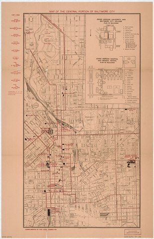
English: Shows streetcar lines in black and other (new?/proposed?) lines in red overprint. Includes "Car lines" legend in red, inset of Johns Hopkins University with index, and inset of Johns Hopkins Hospital with index. Available also through the Library of Congress Web site as a raster image. LC copy brittle, torn at fold lines, possibly removed from textual publication. |
||
| Title | Map of the central portion of Baltimore City | ||
| Shelf ID | G3844.B2P33 191- .M3 | ||
| Date | 1910s | ||
| Source | https://www.loc.gov/item/2002620191/ | ||
| Author | Unknown author | ||
| Permission (Reusing this file) |
|
||
| Other versions |
|
||
| Location | United States · Baltimore. · Maryland · Baltimore | ||
| Part of | American Memory · Cities And Towns · Catalog · Transportation And Communication · Geography And Map Division | ||
| Subject | Street-Railroads · Johns Hopkins University · Central Business Districts · United States · Maps · Maryland · Johns Hopkins Hospital · Baltimore |


Licensing edit
|
This is a faithful photographic reproduction of a two-dimensional, public domain work of art. The work of art itself is in the public domain for the following reason:
The official position taken by the Wikimedia Foundation is that "faithful reproductions of two-dimensional public domain works of art are public domain".
This photographic reproduction is therefore also considered to be in the public domain in the United States. In other jurisdictions, re-use of this content may be restricted; see Reuse of PD-Art photographs for details. | ||||
File history
Click on a date/time to view the file as it appeared at that time.
| Date/Time | Thumbnail | Dimensions | User | Comment | |
|---|---|---|---|---|---|
| current | 02:54, 16 May 2018 |  | 4,387 × 6,809 (85.46 MB) | Fæ (talk | contribs) | LOC Maps https://www.loc.gov/item/2002620191/ #811 |
You cannot overwrite this file.
File usage on Commons
The following page uses this file: