File:Map of the city of Washington showing United States reservations LOC 87694475.jpg

Size of this preview: 666 × 600 pixels. Other resolutions: 267 × 240 pixels | 533 × 480 pixels | 853 × 768 pixels | 1,138 × 1,024 pixels | 2,275 × 2,048 pixels | 18,846 × 16,965 pixels.
Original file (18,846 × 16,965 pixels, file size: 37.75 MB, MIME type: image/jpeg)
Captions
Captions
Add a one-line explanation of what this file represents
Summary
edit| Warning | The original file is very high-resolution. It might not load properly or could cause your browser to freeze when opened at full size. |
|---|
| Description |
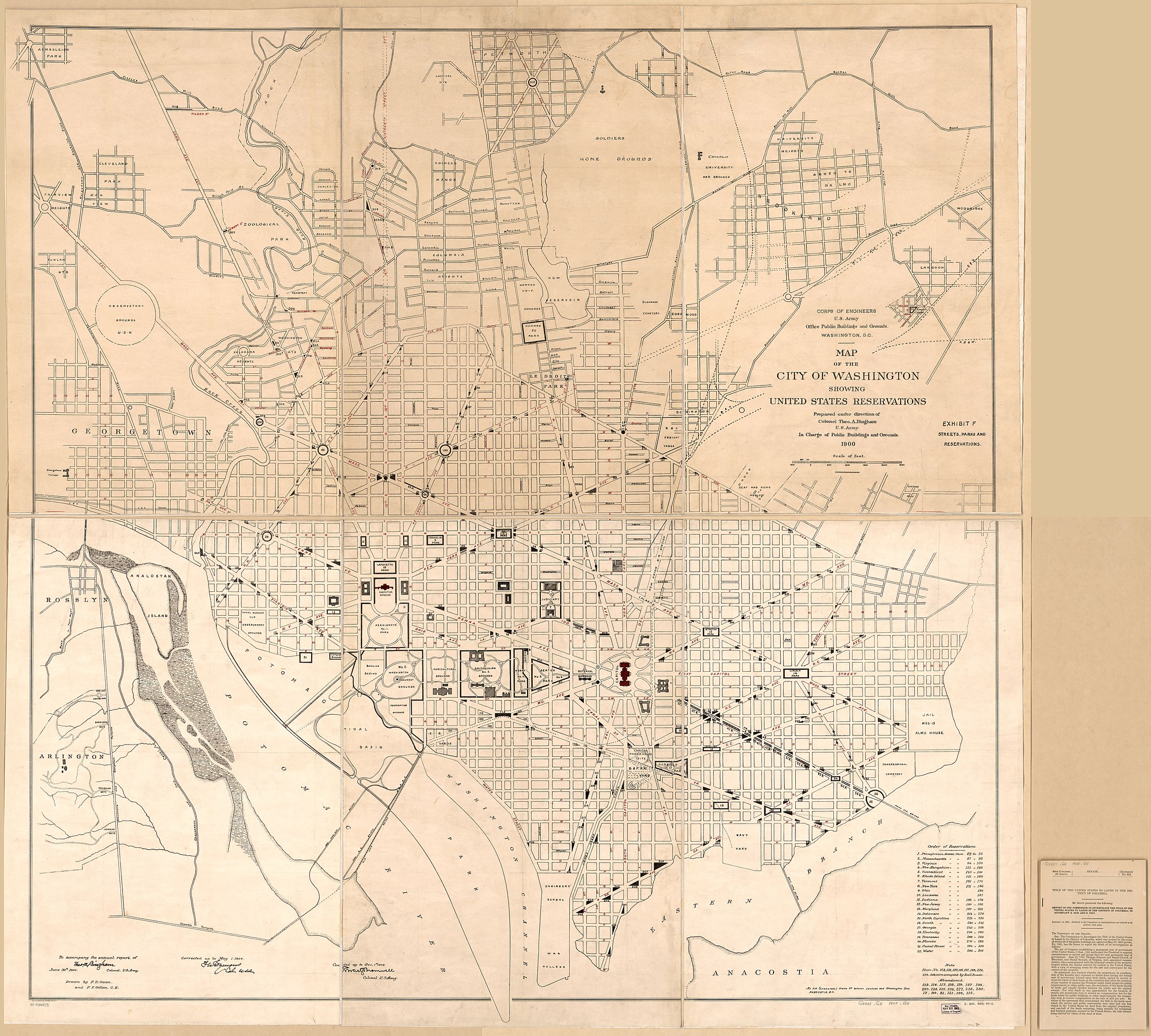
English: At head of title: Corps of Engineers, U.S. Army, Office Public Buildings and Grounds, Washington, D.C. "To accompany the annual report of Theo. A. Bingham, June 30th 1900, Colonel, U.S. Army." "Exhibit F, streets, parks, and reservations." Accompanied by text/index: Title of the United States to lands in the District of Columbia : document no. 653. 94 p. : tables ; 24 cm. Includes notes and table of "Order of reservations." Doc. no. of LC copy annotated in ink to read: 653. LC copy fold-lined, sectioned to 6 sheets, and mounted on cloth backing. Available also through the Library of Congress Web site as a raster image. DCP |
||
| Title | Map of the city of Washington showing United States reservations | ||
| Shelf ID | G3851.G5 1908 .B5 | ||
| Date | |||
| Source | https://www.loc.gov/item/87694475/ | ||
| Author | Bingham, Theo. A. (Theodore Alfred); Bromwell, Chas. S. (Charles Summers); Owen, F. D.; Gillen, F. F.; United States. Congress Senate; United States. Office Of Public Buildings And Grounds | ||
| Permission (Reusing this file) |
|
||
| Location | United States · Washington D.C. · District Of Columbia · Washington | ||
| Part of | American Memory · Cities And Towns · Catalog · Geography And Map Division | ||
| Subject | Public Lands · Washington (D.C.) · Washington · Parks · United States · Maps · District Of Columbia |

Licensing
edit
|
This is a faithful photographic reproduction of a two-dimensional, public domain work of art. The work of art itself is in the public domain for the following reason:
The official position taken by the Wikimedia Foundation is that "faithful reproductions of two-dimensional public domain works of art are public domain".
This photographic reproduction is therefore also considered to be in the public domain in the United States. In other jurisdictions, re-use of this content may be restricted; see Reuse of PD-Art photographs for details. | ||||
File history
Click on a date/time to view the file as it appeared at that time.
| Date/Time | Thumbnail | Dimensions | User | Comment | |
|---|---|---|---|---|---|
| current | 22:38, 25 August 2018 | | 18,846 × 16,965 (37.75 MB) | Fæ (talk | contribs) | LOC Maps https://www.loc.gov/item/87694475/ #7537 |
You cannot overwrite this file.
File usage on Commons
There are no pages that use this file.