File:Map of the federal subjects of Russia (claimed borders since 2022).png
Size of this preview: 800 × 434 pixels. Other resolutions: 320 × 174 pixels | 640 × 348 pixels | 1,024 × 556 pixels | 1,280 × 695 pixels | 2,560 × 1,390 pixels | 6,368 × 3,458 pixels.
Original file (6,368 × 3,458 pixels, file size: 702 KB, MIME type: image/png)
Captions
Captions
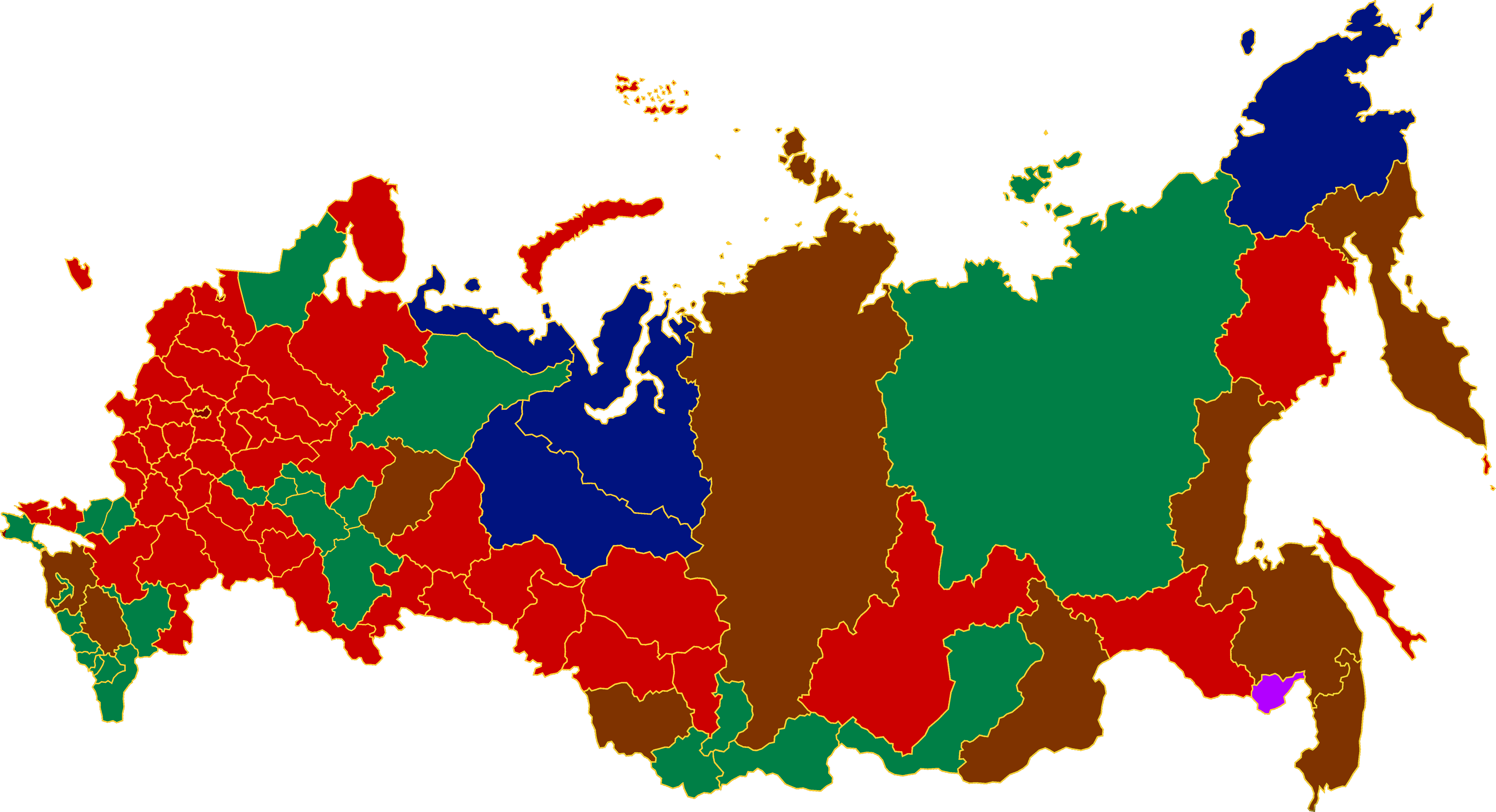
Map of the federal subjects of Russia with its claimed borders.

|
The boundaries on this map show the de facto situation. This is just one of several different views on the subject (see COM:NPOV). |
Summary edit
.png&action=edit§ion=1)
| Description |
English: Federal subjects of Russia: oblasts (in red), republics (in green), autonomous okrugs (in blue), krais (in brown), federal cities (in dark red), and autonomous oblast (in purple). |
| Date | |
| Source | Own work |
| Author | CapLiber |
| Other versions |
Own work based on: Map of Russian districts 2022-09-30.png: |
Licensing edit
.png&action=edit§ion=2)
I, the copyright holder of this work, hereby publish it under the following license:
This file is licensed under the Creative Commons Attribution-Share Alike 4.0 International license.
- You are free:
- to share – to copy, distribute and transmit the work
- to remix – to adapt the work
- Under the following conditions:
- attribution – You must give appropriate credit, provide a link to the license, and indicate if changes were made. You may do so in any reasonable manner, but not in any way that suggests the licensor endorses you or your use.
- share alike – If you remix, transform, or build upon the material, you must distribute your contributions under the same or compatible license as the original.
File history
Click on a date/time to view the file as it appeared at that time.
| Date/Time | Thumbnail | Dimensions | User | Comment | |
|---|---|---|---|---|---|
| current | 22:41, 12 August 2023 | | 6,368 × 3,458 (702 KB) | CapLiber (talk | contribs) | Uploaded own work with UploadWizard |
You cannot overwrite this file.
File usage on Commons
The following page uses this file:
.png&oldid=792964327)