File:Map of the southern Balkans, 1410.svg

Size of this PNG preview of this SVG file: 679 × 600 pixels. Other resolutions: 272 × 240 pixels | 543 × 480 pixels | 869 × 768 pixels | 1,159 × 1,024 pixels | 2,318 × 2,048 pixels | 2,217 × 1,959 pixels.
Original file (SVG file, nominally 2,217 × 1,959 pixels, file size: 2.56 MB)
Captions
Captions
Add a one-line explanation of what this file represents
Summary edit
| Description |
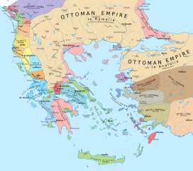
English: Political map of the southern Balkans and western Anatolia in 1410. Disclaimer: The borders shown are often uncertain and conjectural; an effort has been made to be as accurate as possible and follow the relevant scholarship, but errors or omissions may still be present. Any help in correcting and/or improving this work would be greatly appreciated. |
| Date | |
| Source |
Own work using:
|
| Author | Constantine Plakidas |
Licensing edit
I, the copyright holder of this work, hereby publish it under the following license:
This file is licensed under the Creative Commons Attribution-Share Alike 4.0 International license.
- You are free:
- to share – to copy, distribute and transmit the work
- to remix – to adapt the work
- Under the following conditions:
- attribution – You must give appropriate credit, provide a link to the license, and indicate if changes were made. You may do so in any reasonable manner, but not in any way that suggests the licensor endorses you or your use.
- share alike – If you remix, transform, or build upon the material, you must distribute your contributions under the same or compatible license as the original.
File history
Click on a date/time to view the file as it appeared at that time.
| Date/Time | Thumbnail | Dimensions | User | Comment | |
|---|---|---|---|---|---|
| current | 10:16, 2 April 2023 | | 2,217 × 1,959 (2.56 MB) | Cplakidas (talk | contribs) | cleanup of whitespaces, white background instead of transparent |
| 16:24, 19 November 2019 |  | 2,217 × 1,959 (2.58 MB) | Cplakidas (talk | contribs) | forgot some things.. | |
| 16:17, 19 November 2019 |  | 2,217 × 1,959 (1.29 MB) | Cplakidas (talk | contribs) | modified Byzantine borders in Bithynia to cover northern part of the Gulf of Nicomedia/Izmit (cf. en:Treaty of Gallipoli) | |
| 14:46, 23 March 2018 |  | 2,217 × 1,959 (3.42 MB) | Cplakidas (talk | contribs) | city names to paths | |
| 13:46, 23 March 2018 |  | 2,217 × 1,959 (2.39 MB) | Cplakidas (talk | contribs) | User created page with UploadWizard |
You cannot overwrite this file.
File usage on Commons
The following 5 pages use this file:
.jpg)
File usage on other wikis
The following other wikis use this file:
- Usage on ar.wikipedia.org
- Usage on azb.wikipedia.org
- Usage on bg.wikipedia.org
- Usage on bs.wikipedia.org
- Usage on de.wikipedia.org
- Usage on en.wikipedia.org
- Usage on fr.wikipedia.org
- Usage on he.wikipedia.org
- Usage on hu.wikipedia.org
- Usage on hy.wikipedia.org
- Usage on it.wikipedia.org
- Usage on ka.wikipedia.org
- Usage on mk.wikipedia.org
- Usage on pl.wikipedia.org
- Usage on pt.wikipedia.org
- Usage on ru.wikipedia.org
- Usage on sl.wikipedia.org
View more global usage of this file.