File:MapaSociedadesAutóctonasCostaRica.JPG

Size of this preview: 652 × 600 pixels. Other resolutions: 261 × 240 pixels | 522 × 480 pixels | 1,000 × 920 pixels.
Original file (1,000 × 920 pixels, file size: 102 KB, MIME type: image/jpeg)
Captions
Captions
Add a one-line explanation of what this file represents

|
This map image could be re-created using vector graphics as an SVG file. This has several advantages; see Commons:Media for cleanup for more information. If an SVG form of this image is available, please upload it and afterwards replace this template with
{{vector version available|new image name}}.
It is recommended to name the SVG file “MapaSociedadesAutóctonasCostaRica.svg”—then the template Vector version available (or Vva) does not need the new image name parameter. |

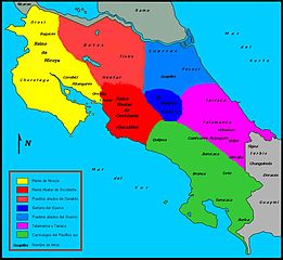
| Description | Mapa de las sociedades autóctonas costarricenses del siglo XVI a la llegada de los españoles (1502), según el mapa elaborado por Mario Porras y Laura Sancho en 1998, publicado en el libro de Ana María Botey Sobrado (2002): Costa Rica: de las sociedades autóctonas hasta 1914, Editorial de la UCR, p.71, ISBN 9977-67-694-1. |
| Date | (UTC) |
| Source | |
| Author |
|
| This is a retouched picture, which means that it has been digitally altered from its original version. Modifications: Se divide el mapa por colores para delimitar las sociedades autóctonas costarricenses del siglo XVI. Se agrega una leyenda por colores. Se agregan los nombres de las respectivas etnias y reinos según el mapa elaborado por Mario Porras y Laura Sancho en 1998, publicado en el libro de Ana María Botey Sobrado (2002): Costa Rica: de las sociedades autóctonas hasta 1914, Editorial de la UCR, p.71, ISBN 9977-67-694-1. Se retiran las leyendas "Costa Rica", "Mar Caribe", "Océano Pacífico" y el mapa de la Isla del Coco, y se substituyen por "Mar del Norte" y "Mar del Sur". Se agrega la rosa náutica marcando el norte. Se guarda el archivo en versión .jpg. Programa utilizado: PaintBrush.. The original can be viewed here: Mapa CR.svg:
|
I, the copyright holder of this work, hereby publish it under the following licenses:
This file is licensed under the Creative Commons Attribution-Share Alike 2.5 Generic, 2.0 Generic and 1.0 Generic license.
- You are free:
- to share – to copy, distribute and transmit the work
- to remix – to adapt the work
- Under the following conditions:
- attribution – You must give appropriate credit, provide a link to the license, and indicate if changes were made. You may do so in any reasonable manner, but not in any way that suggests the licensor endorses you or your use.
- share alike – If you remix, transform, or build upon the material, you must distribute your contributions under the same or compatible license as the original.
| This file is licensed under the Creative Commons Attribution-Share Alike 3.0 Unported license. | ||
| ||
| This licensing tag was added to this file as part of the GFDL licensing update. |

|
Permission is granted to copy, distribute and/or modify this document under the terms of the GNU Free Documentation License, Version 1.2 or any later version published by the Free Software Foundation; with no Invariant Sections, no Front-Cover Texts, and no Back-Cover Texts. A copy of the license is included in the section entitled GNU Free Documentation License. |
You may select the license of your choice.
Original upload log edit
This image is a derivative work of the following images:
- File:Mapa_CR.svg licensed with Cc-by-sa-2.5,2.0,1.0, Cc-by-sa-3.0-migrated, GFDL
- 2007-07-07T15:58:04Z Shamhain 722x664 (78842 Bytes) {{Information |Description= Mapa de Costa Rica |Source= Trabajo propio |Date= 07-07-2007 |Author= Shamhain |Permission= |other_versions= }}
- 2007-07-07T03:02:53Z Shamhain 722x664 (76503 Bytes) {{Information |Description= mapa del territorio costarricense |Source= Own Work |Date= 07-06-2007 |Author= Shamhain |Permission= |other_versions= }}
- 2007-07-07T01:34:33Z Shamhain 722x664 (79667 Bytes) {{Information |Description= Mapa del territorio Costarricense |Source= Own Work |Date= 07-06-2007 |Author= Shamhain |Permission= |other_versions= }}
- 2007-07-07T01:30:12Z Shamhain 722x664 (79666 Bytes) {{Information |Description= Mapa de Costa Rica |Source= Own Work |Date= 07-06-2007 |Author= Shamhain |Permission= |other_versions= }}
Uploaded with derivativeFX
File history
Click on a date/time to view the file as it appeared at that time.
| Date/Time | Thumbnail | Dimensions | User | Comment | |
|---|---|---|---|---|---|
| current | 20:21, 20 September 2011 | | 1,000 × 920 (102 KB) | Rodtico21 (talk | contribs) | {{Information |Description=Mapa de las sociedades autóctonas costarricenses del siglo XVI a la llegada de los españoles (1502), según el mapa elaborado por Mario Porras y Laura Sancho en 1998, publicado en el libro de Ana María Botey Sobrado (2002): ' |
You cannot overwrite this file.
File usage on Commons
The following 3 pages use this file:
File usage on other wikis
The following other wikis use this file:
- Usage on avk.wikipedia.org
- Usage on ca.wikipedia.org
- Usage on cs.wikipedia.org
- Usage on de.wikipedia.org
- Usage on es.wikipedia.org
- Usage on fr.wikipedia.org
- Usage on lt.wikipedia.org
- Usage on nl.wikipedia.org
- Usage on uk.wikipedia.org
- Usage on www.wikidata.org