File:Mapa Punta del Llobregat 1949.pdf

Size of this JPG preview of this PDF file: 800 × 598 pixels. Other resolutions: 320 × 239 pixels | 640 × 478 pixels | 891 × 666 pixels.
Original file (891 × 666 pixels, file size: 1.71 MB, MIME type: application/pdf)
Captions
Captions
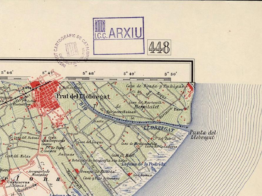
Part of a military map showing the situation of the lighthouse in 1949.
Summary edit
| Description |
Català: Mapa cartogràfic militar de la zona riu Llobregat.
Français : Carte cartographique militaire de la zone fluviale du Llobregat.
English: Military cartographic map of the Llobregat river area.
Deutsch: Militärische kartografische Karte des Llobregat-Flussgebiets. |
| Date | 1-1-1949 |
| Source | Institut Cartogràfic de Catalunya. Domini públic. https://cartotecadigital.icgc.cat/digital/collection/mtn50/id/1538/rec/2 |
| Author | Dirección General del Instituto Geogràfico y Catastral. Servicio Geogràfico del Ejército Español |
Licensing edit
This file is licensed under the Creative Commons Attribution-Share Alike 4.0 International license.
- You are free:
- to share – to copy, distribute and transmit the work
- to remix – to adapt the work
- Under the following conditions:
- attribution – You must give appropriate credit, provide a link to the license, and indicate if changes were made. You may do so in any reasonable manner, but not in any way that suggests the licensor endorses you or your use.
- share alike – If you remix, transform, or build upon the material, you must distribute your contributions under the same or compatible license as the original.
File history
Click on a date/time to view the file as it appeared at that time.
| Date/Time | Thumbnail | Dimensions | User | Comment | |
|---|---|---|---|---|---|
| current | 09:23, 30 December 2022 |  | 891 × 666 (1.71 MB) | Konkordia (talk | contribs) | Uploaded a work by Dirección General del Instituto Geogràfico y Catastral. Servicio Geogràfico del Ejército Español from Institut Cartogràfic de Catalunya. Domini públic. https://cartotecadigital.icgc.cat/digital/collection/mtn50/id/1538/rec/2 with UploadWizard |
You cannot overwrite this file.
File usage on Commons
There are no pages that use this file.
File usage on other wikis
The following other wikis use this file:
- Usage on ca.wikipedia.org