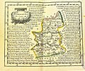
File:Mapa de Estremadura, por Tomás López (1756).jpg

Original file (1,529 × 1,252 pixels, file size: 1.76 MB, MIME type: image/jpeg)
Captions
Captions
Summary edit
| DescriptionMapa de Estremadura, por Tomás López (1756).jpg | Map of Extremadura |
| Date | |
| Source | http://www.paseovirtual.net/america/#1 |
| Author | Tomás López |
Licensing edit
| Public domainPublic domainfalsefalse |
|
This work is in the public domain in its country of origin and other countries and areas where the copyright term is the author's life plus 100 years or fewer. | |
| This file has been identified as being free of known restrictions under copyright law, including all related and neighboring rights. | |
https://creativecommons.org/publicdomain/mark/1.0/PDMCreative Commons Public Domain Mark 1.0falsefalse
File history
Click on a date/time to view the file as it appeared at that time.
| Date/Time | Thumbnail | Dimensions | User | Comment | |
|---|---|---|---|---|---|
| current | 14:44, 7 July 2016 |  | 1,529 × 1,252 (1.76 MB) | Alonso de Mendoza (talk | contribs) | Mejor |
| 21:27, 20 April 2009 |  | 750 × 628 (294 KB) | Rαge (talk | contribs) | elimino línea central, disimilo un poco el doblez | |
| 10:29, 13 July 2007 |  | 750 × 628 (102 KB) | Manuel.Frutos (talk | contribs) | {{Information |Description=Map of Extremadura |Source=http://www.paseovirtual.net/america/#1 |Date=1756 |Author=Thomas Lopez |Permission= |other_versions= }} |
You cannot overwrite this file.
File usage on Commons
The following 3 pages use this file:
- Atlas of Extremadura
- File:Mapathomas.jpg (file redirect)
File usage on other wikis
The following other wikis use this file:
- Usage on ast.wikipedia.org
- Usage on azb.wikipedia.org
- Usage on en.wikipedia.org
- Usage on eo.wikipedia.org
- Usage on es.wikipedia.org
- Usage on fr.wikipedia.org
- Usage on pt.wikipedia.org
- Usage on qu.wikipedia.org
Metadata
This file contains additional information such as Exif metadata which may have been added by the digital camera, scanner, or software program used to create or digitize it. If the file has been modified from its original state, some details such as the timestamp may not fully reflect those of the original file. The timestamp is only as accurate as the clock in the camera, and it may be completely wrong.
| Width | 1,529 px |
|---|---|
| Height | 1,283 px |
| Bits per component |
|
| Pixel composition | RGB |
| Orientation | Normal |
| Number of components | 3 |
| Horizontal resolution | 72 dpi |
| Vertical resolution | 72 dpi |
| Software used | Adobe Photoshop CS6 (Windows) |
| File change date and time | 16:43, 7 July 2016 |
| Exif version | 2.2 |
| Color space | sRGB |
| Date and time of digitizing | 18:42, 7 July 2016 |
| Date metadata was last modified | 18:43, 7 July 2016 |
| Unique ID of original document | 8A1B106F66395F4742855D052BC6D9BD |
| IIM version | 16,379 |